
 |
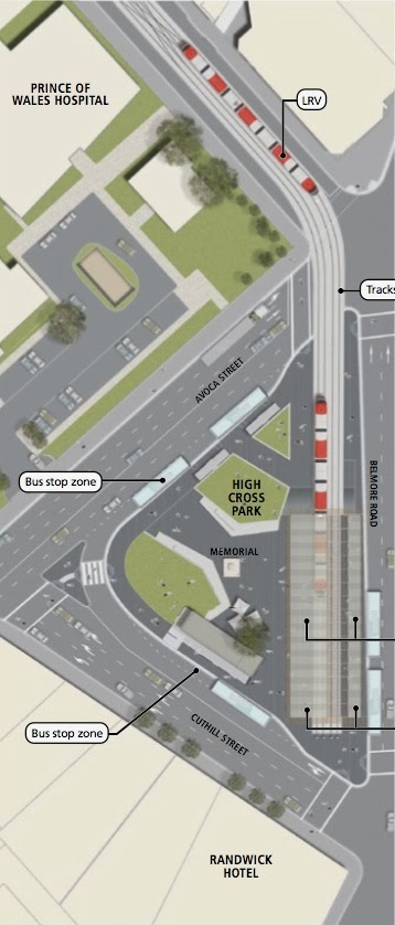
| Tilted figure 5.34 |
The EIS states that 85% of passengers on the cattle cars will transfer from buses. But what happens to the public buses when they have discharged their seated passengers onto the privately-operated cattle cars that have 80 seats and standing room only for 220. Believe it or not, they are to be forced to continue to Circular Quay, which is the only place in the CBD where they can physically turn around, using the route of the AM and PM peak X-services, paying the toll to the private operators of the Eastern Distributor. The difference is that O'Farrell will not permit the public buses to enter Elizabeth Street: they must return via the Eastern Distributor.
 |
| CSELR_Project_Info_Boards_Sept_2013 |
On their return the buses must make the forbidden right-hand turn into Avoca Street and pick up passengers on the other two sides of the triangle. There are separate platforms for the AM and PM peaks for the cattle cars - they switch tracks at the top of the diagram. I am not making any of this up.
Currently buses from the South-Eastern Suburbs access Elizabeth Street in the AM peak from Bent Street via the Distributor or from Liverpool Street via Flinders and Oxford Streets. Between the two they reach destinations in the central CBD in less than half the time it would take a tram to cut a swath through Surry Hills and China Town even with a multimillion dollar underpass under Anzac Parade. The very small number of passengers that need to go the final stop to Circular Quay can, with the Oyster (aka Opal) Card, catch any bus in Phillip Street. They are are coming through not every three or six minutes but every 10 seconds (bumper-to-bumper) and are at this stage carrying only a few passengers. In the PM peak buses return quickly all the way to Circular Quay using the Distributor before picking up passengers in Elizabeth Street.
So it is easy to see why O'Farrell will do anything to stop the buses from entering Elizabeth Street. But what can he do? Write draconian penalty clauses in contracts with PPPs? Make it a criminal offense for someone from the south-west to set foot in Elizabeth Street?
 |
| Street View of Belmore Road from previous post |
It does not appear to be physically possible for vehicles other than buses to access La Perouse Road or Coogee Bay Road (a major local arterial) from Belmore Road or Avoca Street. The figure 5.34 in the EIS has been tilted and very carefully cropped to conceal the fact that there will be at most one lane for all the traffic from Belmore Road and Avoca Street to reach the local arterials. The impact this will have, in conjunction with the diversion of pedestrian traffic, on businesses in the heart of Randwick are too horrible to contemplate.
When buses proceed north of the Randwick triangle they have only one destination - Manly. Businesses can forget about dressing up their windows. The south-eastern bus services will exist solely for the benefit of Manly residents.
The Minister for Transport has had Questions on Notice in Parliament about the CLESR Project and has replied that the 13 December 2012 brochure fully disclosed the project and has told questioners to wait for the EIS. For the EIS as well to be deliberately deceptive shatters one's belief in the Westminster System of Government.

Deliberate deception is systemic within Transport for NSW. But now we've seen everything. We can die happy.
Make it a criminal offense for someone from the south-west to set foot in Elizabeth Street?
ReplyDeleteAn interesting observation. The Kingsford interchange will be an impediment for residents in the far south east (Little Bay, La Perouse, Malabar, Chifley) to venture to the city for entertainment. Changing from tram to bus late at night won't be attractive. Conversely city based tourists will be less inclined to visit the south east, particularly historic La Perouse. Fledging Aboriginal Tourism groups - see example of workshops http://laperouse.info/?p=3896 - will be disadvantaged.