Thursday 31 October 2013

Mind your PPP's and Queues

 
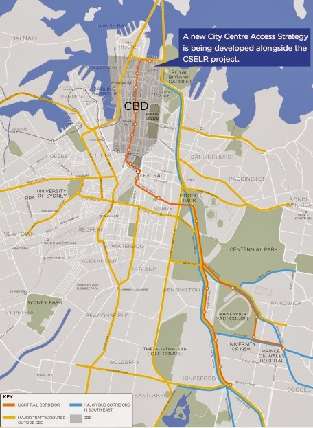
The 13 Dec brochure had the diagrams above purporting to show the numbers of buses that would be removed from the CBD during the morning peak hour by the trams. I apologize for reproducing such deceptive diagrams in an impeccable blog. PUSH has asked TfNSW in writing to clarify which bus services would be terminated only to be told that bus routes are still being modelled. This will still be the case when the ESI is released.

In fact TfNSW is only claiming the "light rail would take 180 buses out of the CBD while additional bus network changes would bring this to a total of about 220 fewer buses entering the city centre in the morning peak hour." However more than half the buses "taken out of the city centre" are passing tangentially to the CBD along Eddy Avenue to "Railway Square" - the bus layover in Lee Street. It is easy enough to generate these figures - just download the time tables and add up the buses during the chosen hour, but the data is meaningless without knowing the patronage at different stages of the route.

Bus services from the south east are spoiled for choice of how to approach the city:
  • Cleveland Street then Chalmers Street 
  • Foveaux Street
  • Flinders Street, Oxford Street then Liverpool Street
  • The Eastern Distributor from Drivers Triangle to Bent Street
TfNSW clearly intends to shut down routes using Foveaux Street, forcing buses to negotiate the one lane remaining in Chalmers Street.

The X factor

Major bus routes from south east
The bus routes using the Eastern Distributor were introduced by previous, competent State Governments. The routes start with an X rather than a 3 and operate to all the south eastern suburbs. In the morning peak hours the buses stop in Bent Street then proceed to Martin Place and back along Elizabeth Street, Liverpool Street, Oxford Street and Flinders Street to the exclusive bus roadway in Moore Park. The buses travel through the Randwick civic and retail centre in Belmore Road and take 15 minutes to get from Randwick Junction (the intersection of Belmore Road and Alison Street) to Bent Street and take 17 minutes to get to Martin Place. These services avoid the Elizabeth-Street-northbound bridgehead between the St James Centre and the Old Supreme Court Building and can be readily expanded. There are potential supplimentary routes using Macquarie Street and Castlereagh Street.
Bent Street, 9 AM
The buses are packed, as you would expect, since Bent Street is an office-space hub with Aurora Place, Chifley Tower, the Governor Macquarie and Governer Phillip towers and the new Richard Rogers designed tower, 8 Chifley. Then there are the office towers at Martin Place.
Commuters in Coogee and Maroubra, with the trams, will have a choice of:
  1. an express bus service travelling at 60 kph in the exclusive bus roadway, having, potentially, priority entry to the expressway then travelling at 80 kph to Bent Street, or
  2. catch a bus that dumps them a long way east of Cuthill Street in Coogee Bay Road or a long way south of Cuthill Street in Perouse Road, then circles the Randwick Triangle while they trudge through rain, hail and sleet to the Randwick Triangle, then wait up to 6 minutes in peak periods to transfer to a cattle car (see the post on the Randwick Triangle). TfNSW claims there will be a 20 minute journey time to Central Station then a 15 minute journey time to Circular Quay, but these assertions are based on infantile assumptions - TfNSW will not allow expert modelling. The cattle cars will in fact be travelling at 10 kph through the "pedestrianized" areas. Even accepting the figures, the journey times, not including the time for walking and waiting for the cattle cars, are more than twice the times currently achieved by the bus services.
Needless to say, no one in their right mind would transfer to light rail. So TfNSW has a stratagem. The map above is from the "Info Boards" released in September, 2013. The bus services from the south east do not travel along Elizabeth Street but go, presumably, to the Phillip Street terminus. This is really bad news for residents in Randwick as the only destination they can reach by bus is the ferry terminals. To reach any other destination in the CBD, say from Randwick Junction, they will need to walk the whole length of Belmore Road to catch the cattle cars.

Fortunately, it is ridiculously easy for future State Governments to reverse this decision. Investors contemplating investing in a PPP (Private Public Partnership) will need to bear this in mind. The O'Farrell Government has suffered swings in by-elections greater than those seen in the Wranslides.

The arguments above also apply to the Xnn services along Anzac Parade but we do not have enough information on the tram stops along Anzac Parade to elaborate at this time.

The Xnn bus services from the south east cannot be crushed as they avoid the bridgehead in Elizabeth Street northbound at the Old Supreme Court Building. It is physically impossible, however, for the bus services displaced from George Street by the tramway - the Parramatta Road and City Road services and the Harbour Bridge to Railway Square services - to avoid this bottleneck. They are completely and irretrievably ...  mind your p's and q's.

Monday 28 October 2013

The fatal flaw

Eddy Avenue
Eddy Avenue bus stop, Monday, 5PM
The 9/11 13 brochure states baldly: "approximately every second bus service ... via Broadway will only  operate to Central. The remaining services will continue to the northern end of the city centre via Elizabeth Street northbound". So commuters catching a bus in Parramatta Road and in King Street, Enmore Road and Stanmore Road will have a binary choice of destinations, Central or Circular Quay. With the Oyster (aka Opal) Card, commuters from further out can change destinations at any bus stop in Parramatta Road or King Street.
Eddy Avenue pedestrian crossing, 5PM
Commuters intending to transfer to a train to north of the Harbour or a southbound train, at Central Electric, will have a choice of alighting from a "Circular Quay" bus at the stop above and using the highly-used pedestrian crossing (left) along side, or being dumped in Pitt Street from a "Central" bus. The bus services of choice for commuters transferring to trains or buses along Elizabeth Street south, is a lay down misere.

When commuters on "Circular Quay" buses leave the bus at Eddy Avenue, the emptied buses must proceed to Phillip Street as it is the only place in the CBD where they can physically turn around. This is the worst possible scenario for the Eastern Suburbs bus services that have been dependent on the Phillip Street terminus from the earliest days of the colony, and for the Harbour Bridge bus services that TfNSW intends to terminate at Railway Square and beyond. The only way to force Public-Bus passengers to transfer to privately-operated cattle cars in Rawson Place is to generate intolerable congestion in Elizabeth Street northbound between the St James Centre and the Old Supreme Court Building. The gridlock in Elizabeth Street will need to occur not only during the morning peak hour, but for most of the day, for the Project to be supported by PPP investors.

Passengers hoping to catch a "Circular Quay" bus from stops in Parramatta Road closer to the CBD, and City Road, such as the stops at Sydney University, will just see the full buses pass them by. To catch bus service along Crown Street they will have to transfer to a tram and travel one stop, then walk across town to Elizabeth Street. To catch a New South Head Road bus service they will have to transfer to a tram and travel three stops, then walk across town.

O'Farrell really has it in for people in the Eastern Suburbs, southern Sydney and western Sydney.

Sunday 27 October 2013

You will have no choice


Light poles at Railway Square
When the bus layover from Lee Street was built the government exhibited plans for "improvements" to Railway Square and George Street. Previously buses had circled the bus stop island, bending the supports for the shelters, so it had to be a big improvement.

I objected vehemently to George Street being reduced to two lanes between Liverpool Street and Bathurst Street northbound. I argued that developers could be encouraged to continue the extension of the underground plaza above Town Hall station and the colonnades begun by the pinstripe office tower. I added that the proposed light towers were aesthetically inferior to the existing towers and asked for the escalators on the east side of Lee Street to be retained. As you can see my comments came to naught. The final report did address the matter of colonnades however. The Lord Mayor, Frank Sartor, later demonized colonnades saying they allowed criminals to avoid CCTV cameras. The City Council has been granting property owners bonuses to the floor space ratios to build shop fronts to their site boundaries.
The narrowing of George Street just before the critical section in front of the Town Hall creates congestion at the only places that buses can make a right-hand turn. There is in fact a short right-hand turn lane at Bathurst Street and a very important bus-only right-hand turn lane into Park Street. This right-hand turn lane allows some bus routes (remarkably few) to divert to a terminus in the forecourt of the Domain car park, one of the few places in the vicinity of the CBD, apart from Circular Quay and other dead-ends at Walsh Bay, where it is physically possible for buses to turn around.
Domain car park forecourt
Bus-only lane back to William St.
The Deputy Director General of TfNSW, Chris Lock, asserted at public meetings in April, that congestion in George Street north of Market Street caused delays of up to half an hour during the morning peak from 8 to 9 AM. A rational human being would deduce from this that not enough buses were being diverted to the Domain forecourt at this short period of the day, for five days of a week.

The buses that use this terminus are long range routes through Strathfield and Burwood, but with the Oyster (aka Opal) card where a bus route terminates in the CBD is largely irrelevant. Regardless of the destination on the front of the bus that circulates through the local roads, you can get of at any stop in the shared corridor, in this case Parramatta road, and wait for a bus to your preferred destination. If you are smart you will make your move at section boundaries and as far from the CBD as possible - buses to prized destinations will pack to the rafters early on and become set-down only services, leapfrogging stops, an added incentive to change routes early.

The Domain forecourt terminus would be the prized terminus for passengers headed for destinations in the Eastern Suburbs. You disembark in Park Street, walk around the corner and catch a bus to the Eastern Suburbs. The Domain forecourt bus layover can be improved for a fraction of the claimed $1.6 billion that O'Farrell wants from the Federal Government, for a tramway that will have slower journeys to Circular Quay than the existing bus services. Eliminating the only places in the CBD where buses can physically turn around in order to provide a tram service that does not need space to turn around is not rational.

The 9/11 13 brochure states that "approximately every second bus service ... via Broadway will only (sic) operate to Central. The remaining services will continue to the northern end of the city centre". So the elimination of the bus-only right-turn lane by the tramway spells the end to the bus services using the Domain forecourt.
TfNSW has made a preemptive strike. From last May the bus services from Strathfield to the Domain along Riley Street were ended. They still use the forecourt to turn around (it is the only place they can physically turn round) but they layover (wait for their scheduled start) at a stop in Cathedral Street. The first pick-up stop is in George Street.

So will these services be terminated at "Central", i.e. Pitt Street? The 13 Dec brochure stated authoritatively that 33 of the 175 buses entering the CBD via Broadway during the peak hour would be eliminated but TfNSW has refused to say how. Now they are saying approximately 88 buses will be terminated; but this is clearly a back of the beer coaster figure. TfNSW has given up on trying to model bus routes.

TfNSW started negotiations with the companies that package PPPs ( Public Private Partnerships) for the usual kamikaze investors on 21 October, so they must be telling them which bus services will be terminated in Pitt Street, "under commercial privilege". Are they also telling them they will incorporate draconian penalty clauses or legislate to prevent future governments redirecting them? The assumption for investors to swallow is that passengers on terminated bus routes stay on until the end and can be shepherded onto cattle cars. This ain't so with the Oyster card.

The commuters that use the bus services to get to work will not be receiving any notice of their impending fate any time soon - not before the Project is commenced. O'Farrell is adopting the Robin Askin Stratagem -  commence construction so future governments cannot reverse any of the decisions. This failed in the past when Neville Wran cancelled contracts to build the skyway carriageways in Darling Harbour and went on to inspire a new word, Wranslide.

Wednesday 23 October 2013

Push polling

When the O'Farrell government forced Clover Moore to resign as the state member for Sydney or from the Sydney City Council, there was a by-election for the NSW parliament. During the campaign the Liberal Party made a childish attempt at push polling. Voters were asked which policies of the O'Farrell Government they approved. The policies were being tough on criminals and four similar policies. I threw the letter straight in the recycling bin. The electors voted with their feet and put the boots into the endorsed Liberal candidate.

When Public Servants resort to push polling though, the public has no mechanism to deal with them. No NSW public servant has ever been dismissed for incompetence. They have an assured salary until the age of 68 and superannuation paid by the taxpayer.

TfNSW has been using push polling to quell opposition to the Light Rail Project and now we have the 9/11 13 brochure which was designated "for further consultation". The website has a page engage.haveyoursay which asks for public comment on the Sydney Centre Access Strategy. The public is asked what are three ways the SCCAS could be strengthened in regards to RAIL, LIGHT RAIL, BUSES etc. Since the brochure contains no details on any of these it is hard to imagine anyone being naive enough to respond.

However there is a box that allows a file to be uploaded so I have uploaded a letter addressing some of the inconsistencies in the brochures and some of the obvious flaws in the strategy. I doubt if anyone in the department will pay attention to this but we must live in hope. The letter can be viewed here.

Saturday 19 October 2013

Birdbrained

"It is not mathematically possible."
Joe Biden  (US Vice-President)

The Deputy Director General of TfNSW, Chris Lock, told the Randwick burghers business breakfast in April: "There's a queue of buses coming over the Harbour Bridge all trying to get to York Street around Wynyard, and they back up, and the queue sometimes starts on the northern side. So what have we done? A little thing. We have moved 60 of those buses in the mornings. Instead of going to Wynyard they go the Cahill Expressway, and they come into the city from the Macquarie Street end. It is such a little thing!" The 13 Dec 20012 brochure asserts: "These buses would terminate at Bridge Street."
There are no active bus stops in Bridge Street and 6 months later there is no information at any of the bus stops at Circular Quay to say where they terminate. The dysfunction of TfNSW is terminal! The very helpful staff at the information booths and ticket-seller booths at Circular Quay have no information about the 60 buses. The Transport for NSW web sites have no information on these bus routes and the trip finder app does not find them at the relevant times. The trip finder finds the Metrobus no. 200 route from Bondi Junction to Chatswood Station via Ocean Street, New South Head Road, Macquarie Street, the Cahill Expressway and the Pacific Highway that was set up by the previous, competent State Government, but there is no trace of the bus services terminating at Bridge Street.

Chris Lock told the Randwick breakfast: "And everybody said 'This is going to be a nightmare. There will be uproar, be a disaster.'" So was everybody right, and was the first initiative of TfNSW quietly abandoned? It has not been possible to find out. Since Chris Lock's rock-star reception at the Randwick breakfast in April, he has become a total recluse.

Bus routes, 13 Dec 12 brochure
In the 13 Dec 12 brochure the north of Harbour bus routes (the green arrow pointed at the Harbour Bridge) did not terminate at Bridge Street, despite what was said in the text, but appear to be sharing the Phillip Street terminus; with every other bus route in the CBD. This is, of course, not mathematically possible, but the Minister for Transport has been replying to all Questions in Parliament about the Light Rail Project that the brochure fully disclosed all the details.

The 9/11 13 brochure has a completely different picture of the bus routes. Buses from north of the Harbour do not terminate at Bridge Street but take over the Castlereagh Street south-bound-only bus routes.

There is of course an obvious problem: there is only one lane for north-bound buses between the David Jones store and the old Supreme Court building and there are at least two south-bound bus lanes.

Bus routes, 9/11 13 brochure
When researchers set up bird hides, birds can be disturbed and leave their nests leaving the eggs to cool down and die, which is not what they want to observe. If more than one person enters the hide and not all leave, the birds are reassured and return to the nest. Birds cannot count to two.

O'Farrell must believe that all the residents of the Eastern Suburbs are birdbrained and would not notice the discrepancy. On the other hand it could be O'Farrell that is birdbrained. We will be finding this out at the next State Election.

It was assumed that O'Farrell would be using some of the Parramatta Road and City Road bus services to crush the Eastern Suburbs Public Bus services, but the number of north-of-the-Harbour bus services that can be routed along the north-bound Elizabeth Street bus lane is limitless.

So where will Oxford Street bus services be terminated when north-of -the-Harbour bus services take over Elizabeth Street? The Minister for Transport will be able to tell Parliament that the crude map in the brochure revealed all the details. The diagram shows a "planned city centre key bus corridor" along College Street between William and Oxford Streets. There is no possible explanation for this bus route other than to terminate buses by circling them round the southern half of Hyde Park. Bus passengers forced to disembark in College Street will complete their trips by catching a north-of-the-Harbour bus service in Elizabeth Street. Or they can catch a Victoria Road bus service to Town Hall and be herded onto a cattle car. The (indicative) bus stop precinct (the brown blob) stretches the whole width of the city, from Sussex Street to Hyde Park.

It is worth pointing out that without trams in George Street there are two route for buses from north-of-the-Harbour to return north, Clarence Street and the unused Kent Street, and the Eastern Suburbs bus services are unaffected. Also, less than half the "real estate" in Alfred Street is utilized, and any number of bus services from the north can be accommodated.

Chris Lock told the Randwick breakfast: "For the first time in a generation we are going to redesign the bus network... a century I hear from my right-hand" to guffaws from the burghers. In fact public transport has been using Circular Quay to turn vehicles around for more than two centuries; because it is a dead-end. There is no-where else in the CBD where buses can be turned around efficiently and without causing massive congestion in crucial arterial roads.

In order for the Transport Minister to be able to tell Parliament that it was fully disclosed that bus routes would be terminated in the middle of Hyde Park, without disclosing anything, Chris Lock's right-hand guys had to use only one of the different coloured textas they hold in their right hands when turning maps into creative masterpieces. I hope they were not traumatized.

Thursday 17 October 2013

Last Exit from Barangaroo (expurgated version)

The Menzies Government banned the novel "Last Exit to Brooklyn" - it contains naughty words. Now the O'Farrell Government is redefining the definition of "obscenity".
Deceptive diagram of City Roads in 9/11 13 brochure
Vehicular access to Darling Harbour and Barangaroo from the south is from George Street via Hay Street which is not shown as a one-way road in the 9/11 13 brochure. Vehicular access to the CBD west of George Street from the south and from the Eastern Suburbs is from Liverpool Street, into Kent Street, which is not shown as one-way west of Elizabeth Street and inexplicably ceases to be a "priority route for general vehicle traffic within the city centre" from Elizabeth Street to Pitt Street and west of Kent Street.

Vehicles from New South Head Road have other options: they can access Kent Street from Druitt Street and Barangaroo and Darling Harbour via the cross-city tunnel.
Cross-City Tunnel exit
There are at least five lanes of traffic (the yellow  lines) plus two more from Pier Street, and the Cross City Tunnel, feeding vehicles into Barangaroo and Darling Harbour. Unfortunately, the only way traffic can return to the Eastern Suburbs from Barangaroo via the cross-city tunnel is by looping from Sussex Street into Liverpool Street then into Harbour Street North: Sussex Street is the only exit to the Eastern Suburbs and the southern suburbs whether they use the tunnels or the surface roads. Needless to say, Sussex Street is slowed to a crawl throughout the evening hours on week days - it is quicker to walk.

Binary choice, turn into Bathurst,
or continue to Liverpool Street

Attempts to force drivers to pay the cross city tunnel toll by generating congestion in Bathurst Street and William Street have failed dismally. Nationalizing the loss-making Cross-City Tunnel, in line with Liberal Party ideology, and reducing the toll, will not mitigate congestion in Sussex Street. The Tunnel is a cause of the congestion. Pedestrianizing George Street between Market and Bathurst Streets will force vehicles from the off-street parking in Pitt Street north of Park Street into Sussex Street, and congestion will get much worse as Barangaroo is built.

Private cars can exit Sussex Street, eventually, into Harris Street via Ultimo Road, but Public Transport must get back to Railway Square. Buses could turn into George Street from Bathurst Street but would be forced into one lane to pass  the World Square and Chinatown tram stops and would be hit by traffic displaced from George Street returning with a vengeance from Liverpool Street. Goulburn Street is two lanes each way west of George Street and there will never be right-hand turns into George Street.
Goulburn Street, no way back for buses
The only place where buses can turn efficiently into George Street and make it back to the depot in Lee Street is from Druitt Street. The 13 Dec 20012 brochure stated: "Most people arrive in the CBD via public transport. This means we can see 370 buses moving along George Street outside Town Hall in the morning's busiest hour". This would indicate to a rational person that the section of George Street from Market to Bathurst Street is the most important road for Public Transport in the state, and indeed it is the key to providing efficient services. It can never be "pedestrianized". Turning George Street over to a service for commuters from Maroubra and Prince of Wales Hospital achieves nothing, and apparently makes it impossible for TfNSW to provide public transport for Barangaroo.
"Proposed bus network"
The 13 Dec 12 brochure contains this diagram entitled "Proposed bus network" with the dotted yellow line labelled "Western CBD/Barangaroo corridor" starting with a dot and passing through the middle of Paddy's Market and ending with an arrow at a one-way section of Harris Street. The Deputy Director General of the Transport Projects Division TfNSW, Chris Lock, was more forthcoming at the Community Forum at Sydney High School in April. He confirmed that it had been decided not to proceed with the previous Government's commitment to evaluate building a tram service to Barangaroo - it would not be commercial, he said, since commuters would use the pedestrian tunnel to the underground platforms of Wynyard Station. He said there would be a bus service from Circular Quay, presumably passing under the Harbour Bridge. To reach Barangaroo from Parramatta Road you would be transfered to a cattle car at Rawson Place then back onto a bus for the tortuous trip under the Harbour Bridge.
9/11 13 brochure (full size)
In the 9/11 13 brochure, Barangaroo is only accessible from bus services from the north of the Harbour. There are linkages along Erskine Street, which ends at Wynyard Park, and King Street ending at York Street. There is no indication of how the buses will be turned around.

There have been three completely different indicative plans for bus services issued by TfNSW in less than a year, in the course of developing an Environmental Impact Statement, which we are told will be issued in the next few weeks. None of the plans contain any details whatsoever that would allow them to be independently assessed. Transport for NSW is so dysfunctional as to be beyond belief.

The director-general of TfNSW, Les Wielinga, has retired and the Roads Minister announced his successor yesterday. It will be a Queensland public servant, David Stewart, who was sacked by the Newman Government. He will be walking into an Augean stables when he starts his job later this year or early next year. It is not to much to expect a public servant to have an ethical compass whatever their level of competence. There will be further posts about the above diagram.

Sunday 13 October 2013

"Shock and Awe" in Chalmers Street

Duncan Gay
The Minister for Roads, Duncan Gay, announced on 15th July 2011: "there is no longer an RTA". NSW Maritime, the Transport Construction Authority and Country Rail Infrastructure Authority also ceased to exist. They were subsumed into Transport for NSW a statutory authority created on 1 November 2011 by the O'Farrell government. Transport for NSW (TfNSW) would report to the Transport Minister, Gladys Berejiklian, and would control the functions of Rail Corp and own Metro Transport Sydney. TfNSW would be answerable to no-one and would have no checks or balances.

On 13 December 2012, TfNSW launched an extraordinary attack on the Public Bus services that it had a statutory obligation to administer. The Public Bus services were castigated because "only 19 to 34 per cent of buses achieve running within two or three minutes of the time table in the Anzac Parade and CBD corridor". It was claimed that 97% of trams would achieve this, hardly surprising, since it also claimed that trams in peak periods would not have timetables and would be running every three minutes regardless of how many passengers they carried.

This unprovoked and dastardly attack laid the grounds for the O'Farrell government's ideological assault on Public Transport, however. By making bus services much less likely to run on schedule their status would be further undermined.

TfNSW has contrived to make every bus that is forcibly terminated, at any tram stop, set off immediately, regardless of the scheduled departure. Hardly any bus services will run on schedule!
Chalmers Street now Central Station stop
The only difference between the artists impression of the Chalmers Street stop released in December 2012 and the Central Station stop unveiled on 9/11 13 is the pedestrians. These are supplied in libraries with graphics applications. I could have photoshopped an image of O'Farrell into the final photo of this blog, but why lower myself.

It was in Chalmers Street that TfNSW would deliver its coup de grace to the Public Transport System of NSW.

Elizabeth Street bus services terminated at the Central Station stop, the only stop where they can be terminated, will be forced to insert themselves into a single lane of general traffic in order to make a hairpin turn round the Dental Hospital, then set off again immediately. 

But this alone is not sufficient to cripple the Public Bus services. There are bus services that cannot be terminated such as the "Railway Square" and Crown Street bus services. These must be crushed.

Traffic from the southern suburbs of Sydney has a choice of routes to reach the Wentworth Avenue distributor. Vehicles can use Chalmers Street, or they can use a much more convoluted route of Lee Street then Pitt Street then Eddy Avenue. Needless to say, the preferred route is Chalmers Street. In the bewitching hour of 8-9 AM on the Tuesday in 2005, (page 35, k5sy4.doc) there were 1420 vph in Chalmers Street. There were 1209 vph the previous hour and 1325 vph the following hour then it remained around 1000 vph the rest of the day. On the other hand there were 1063 vph in Lee Street in this period (page 15, k5sy3a), and most of this traffic would have been heading for George Street then Hay Street and Darling Harbour and the Hungry Mile - Skyhigh would be able to determine how much non-bus traffic turns from Lee Street into Pitt Street.
Lee Street, Railway Square
Railway Square bus interchange
This is fortuitous for the Public Bus services since traffic in Chalmers Street has a minimal effect on the entry of buses to the CBD, which can continue regardless of congestion in the central lanes. Prior to the construction of the bus parking area in Lee Street, "Railway Square" bus services would circle the bus island using Little Regent Street, now they are vulnerable to traffic densities in Lee Street, and in particular to traffic turning into Pitt Street.

So, reducing Chalmers Street to one lane forces the traffic it carries into Lee Street and Pitt Street. TfNSW is not only stuffing up the Elizabeth Street bus services, whether they are terminated or carry on to Circular Quay, the "Railway Square" bus services are collateral damage.

And TfNSW does not stop there. The congestion in Pitt Street caused by the incompetent attempt to terminate Parramatta Road and City Road bus services in Pitt Street will force traffic to find yet another alternative route. The only other route that accesses the same destinations as Wentworth Avenue and College Street is Crown Street.

Crown Street in 2005 (page 33, k5sy4) was carrying half the traffic that Chalmers Street carried during the morning - less than 700 vph. The sample station is just south of Devonshire Street. The photo shows the traffic in this section around 8 AM on a Friday.
Crown Street, south of Devonshire Street
The intersection of Cleveland, Baptist and Crown Streets is operating at around capacity at this time so Crown Street is carrying as much traffic as it can. Currently, Devonshire Street distributes north-bound traffic to Bourke Street, Riley Street and Surry Hills west of Crown. The tramway will put a stop to this. Even so Crown Street is currently operating near to capacity further north at Foveaux Street.
Crown Street, south of Foveaux Street, 8 AM
North-bound traffic displaced into Crown Street will have a devastating impact on businesses in Redfern Street, Baptist Street and Crown Street, but most significantly it will cripple bus services that run along Crown Street.

With the master stoke of narrowing Chalmers Street to one lane, O'Farrell will have crippled every bus service south of Sydney Harbour that enters the CBD.

Thursday 10 October 2013

The crunching of Cleveland Street

Cleveland & Crown Streets intersection
Cleveland Street is the boundary between Surry Hills and Redfern. The shopping centre in the left hand corner is in Redfern but changed its name to the more salubrious Surry Hills. Trams ran along Crown and Cleveland Streets in the nineteenth century resulting in the retail strips of today. The intersection of these roads and Baptist Street is the main retail centre for southern Surry Hills and eastern Redfern.

Cleveland Street is only four lanes wide and it is the main distributor for Surry Hills. During the morning peak, vehicles turning right from Cleveland into Crown typically stretch back past Bourke Street (which is one-way south) during each traffic-light phase. The photos above were taken around 8AM on a Friday. Through traffic and traffic turning left into Baptist Street is therefore restricted to one lane.
Cleveland & Elizabeth intersection
East-bound traffic in Cleveland Street is restricted to one lane by right-hand turning traffic into Elizabeth Street.

From the construction of Eddy Avenue at the start of the 20th century, Broadway has been the main artery for traffic heading for the Eastern Suburbs from the west, along Parramatta Road, and from the south-west, along City Road. It still is.

The last traffic flow data published by Transport for NSW is for 2005, but present traffic flows would not be less, and we will be making comparisons only. We will be using the data for Tuesdays as flows on Mondays and Fridays are sometimes not as typical for the other week days. We will use the data for vph from 8-9 AM as Transport for NSW is obsessed with this hour. The data is for eastbound traffic. The sample stations for Broadway are east of Harris Street (page 17, k5sy3a.doc) and west of Wattle Street (page 45, k5sy4.doc).

On the Tuesday of the sample week, 1908 vehicles passed Wattle Street in the allotted hour, and 2212 vehicles entered Railway Square - extra traffic had turned into Broadway from Harris Street. As pointed out previously this traffic has minor impacts on bus movements which pass from Broadway to Rawson Place in less than a minute, come what may. We do not know how many vehicles other than buses turned into George Street as the pneumatic tube data does not distinguish between vehicles, and George Street is a dead-end road north of Hay Street and of no interest to the RTA. Pitt Street north of Eddy Avenue is a dead-end road also. The number of vehicles other than buses that entered the CBD would be a very small proportion of the vehicles that bypassed the CBD tangentially. Skyhigh could provide this information precisely, if they were consulted.

On the other hand, Cleveland Street has been of great interest to the RTA. There are five sample stations along its length: west of Sydney University (page 5, k5sy4.doc), west of Regent Street (page20, k5sy3a), west of Pitt street (page 11 k5sy3a), west of South Dowling Street (page 38, k5sy4) and west of Anzac Parade (page 26, k5sy3a). This data gives a snapshot of how Cleveland Street operates as a Distributor. Of the 1727 vehicles that entered Cleveland Street from City Road during the allotted hour only 1217 reached South Dowling Street and only 1143 vehicles made it to Anzac Parade and thence the Eastern Suburbs. Cleveland Street carried only slightly more than half east-west traffic carried by Broadway.
Transport for NSW is creating insuperable problems for east-west traffic movements. Their deliriously incompetent attempts to establish a bus/tram transfer stop in the critical section of Pitt Street between the historic Anglican Christ Church of St Laurence and the Central colonnade will gridlock traffic movements in Broadway. So they have come up with a solution: draw up a crude map that insists that Broadway is a priority route for general traffic movements within the city center, what ever that may mean, and redefine the Cleveland Street Distributor as The (as in the one the only) Major Route for traffic bypassing the city center.

Renaming existing institutions is TfNSW's modus operandi - Rail Corp and City Rail have become Sydney Trains and NSW TrainLink and a trip to Katoomba is an InterCity trip. Signs at train stations are wrong and covered up. But the redefining of Cleveland Street is much more sinister.

What will O'Farrell be doing? Will he be banning right-hand turns from Cleveland Street and forcing traffic to percolate into Surry Hills from South Dowling Street, say, by removing the blockages at either end of Arthur Street that were designed specifically to prevent this?
Cleveland & Regent Streets intersection
In fact, banning right-hand turns in Cleveland Street, Surry Hills, would not significantly increase the vehicle flow. When the connection was built from Wattle Street to Harris Street and thence to the Western Distributor and Eastern Australia from Kirribilli to Cape York, space was found for two right-hand turn lanes into Abercrombie Street. Cleveland Street, even reduced to one lane at Crown Street, can supply enough traffic for three lanes crossing Regent Street, and together with traffic from Botany Road, can fill the extensive right turn lanes into Abercrombie Street in most traffic light phases.
Cleveland & Abercrombie Street intersection
View west from Regent Street 7:45 AM 

View west from Regent Street 7 PM

View east from Regent Street 7:45 AM
Traffic flow in Cleveland Street is consistently high throughout the day in the working week with small peaks in the mornings and evenings, when clearways are enforced.
Parramatta Road at Sydney Uni
Parramatta Road will be carrying more traffic when connected to  the WestConnex tunnel. For Transport for NSW to assert, without any analysis, that east-west traffic from Parramatta Road can be dog-legged into Cleveland Street is mind-numbingly irresponsible. Cleveland Street will never be able to cope with additional through traffic. TfNSW will be not only congesting east-west traffic movements, they will be congesting north-south movements, and making it a lot more difficult for businesses in Cleveland Street and Crown Street to survive.

The 9/11 13 brochure is insultingly titled "for further consultation". O'Farrell has the responsibility to force TfNSW to consult with the only authorities that have the data to definitely  establish this - the RTA and their consultants Skyhigh. O'Farrell will not allow his whims to be competently assessed, so what can one do?

Sunday 6 October 2013

A lone voice in the wilderness

Sibling rivalry
When the Sydney City Council was being pressed to commit funds for works on George Street for the tram lines one of the councillors asked for the Council to close down the roads that would be affected by the project to judge what the consequences would be before irreversible changes were made. She was howled down by her fellow councillors, who committed $180 million to the project, sight unseen, and increased this by $40 in May. No details of the Project had been released other than the brochure in December. At the meeting in May, Clover Moore said the Federal Transport Minister Albanese had advised her that he was yet to receive a (sane or rational) request for federal funding. OK, he is to much of a gentleman to use the words sane or rational. The NSW Minister for Transport tried to score political points, saying she had sent a letter and a submission for funding to the Federal Transport Minister one month after the release of the brochure on January 14. Now there is an Abbott government to deal with.

The Sydney Morning Herald has published an article by an investigative journalist in this weekend's (October 5-6 2013, Page 9) News Review, about the use of consultants who were former Liberal Party aides and are employed at $4400 a day. Despite the Minister's denial, their initial engagement had come from her office, and their role is reported to be to act as conduits to her office and report on which public servants would follow the Party line. The article is required reading for anyone who wants to understand how staff at Transport for NSW are promoted far beyond their level of competence. But back to the subject of this post.

Unfortunately for Clover Moore, the Council closes down George Street every year for a Chinese New Year Parade. Chalmers Street is not reduced to one lane so the effects are much less severe, but we can make assessments of the impact on traffic. The Parade does not take place on the Chinese New Years Day but on the Sunday evening afterwards. This is presumably when the impact on traffic will be the least.

I was returning from a bike run on one of these Sundays after 5PM and traffic had slowed to a crawl in Parramatta Road from beyond Sydney University. It took hours to reach Surry Hills. When Broadway is gridlocked the bus services from Parramatta Road and City Road are effectively shut down.

The RTA stopped publishing vehicle flow per hour (vph) data after 2005 but traffic in Broadway would not have gotten any less. The vph data for east-bound traffic in Broadway are on page 17 of the file k5sy3a.doc downloaded from the Transport for NSW website.

Gridlocking Broadway is quite a feat
Chinese New Year is not an unexpected event. The moveable signs and overhead signs were saying to expect delays, so everyone who could have avoided Pitt Street would have.

The metering station in Broadway is to the east of Harris Street. On the Sunday of the sample week the vph traffic flows were 1178 vph between 5-6 PM and 1169 vph from 6-7 PM, so a 1170 vph traffic flow will gridlock Broadway and Parramatta Road back to to grey cliffs of Parramatta Road.
Parramatta Road gridlocked too

Needless to say, the vehicle per hour flows during the AM peak from 8 to 9 AM on weekdays are twice the levels that produce gridlock in Broadway and Parramatta Road, but the gridlock extends far beyond this peak. In fact, traffic flows are above 1170 vehicles per hour on week days from 6AM to 7PM or 8PM from Monday to Thursday, from 6AM to Midnight on Fridays, from 8AM to Midnight on Saturdays and from 10AM to 7PM on Sundays.

The data that is available to us dates from 2005 and cannot be used as a smoking gun. The RTA has all the data it needs to assess the consequences of O'Farrell's decision, on a personal whim, to run trams down George Street. They are not being allowed to run these programs. What can one do?

Thursday 3 October 2013

Never the twain did meet.

The Elizabeth Street, Wentworth Avenue, College Street arterial is one of the most important and irreplaceable distributors in Sydney. It receives traffic alternately from Chalmers Street and from Broadway, via Pitt Street and Eddy Avenue, and distributes the traffic to Surry Hills west of Crown, Oxford Street, William Street, Macquarie Street and the Cahill Expressway. The traffic flow from Broadway is also tangental to the CBD and has only a small impact on current bus movements which go from Broadway to Rawson Place in less than a minute (the red line). The only bus routes affected by the east-west traffic movements are the "Railway Square" bus routes (the purple line). These are bus routes from the Eastern Suburbs, understandably, and the mainly bendy bus routes from Chatswood and the Pacific Highway that are inexplicably doglegged into Elizabeth Street via Park Street. I mentioned these previously and will deal with them in more detail in later posts.
The Pitt Street, Eddy Avenue tangental
What O'Farrell will be doing to the Broadway bus services is identical to what he will be doing to the Chalmers Street bus services. Only the street names in the previous post need to be changed.

Ve vill dramatically increase traffic flows in Pitt Street, reduce the number of lanes and force buses to negotiate through this traffic.

As argued before, Elizabeth Street and Macquarie Street will be the only access to the CBD north of Park Street, but there is an additional factor. Traffic from south of McEvoy Street has a choice of travelling north along Botany Road or Elizabeth Street. Elizabeth Street would be the preferred route for traffic heading to the Eastern Suburbs, but, with Chalmers Street reduced to one lane, the traffic would shift to Botany Road and thence Pitt Street and Eddy Avenue.

There are currently no bus stops in the critical section section of Pitt Street between Broadway and Eddy Avenue. Bus services that are forcibly terminated will dump most of their passengers in Pitt Street. All Parramatta Road and City Road bus services will be forced to negotiate through this section of Pitt Street whether they are terminated or enlisted to crush the Elizabeth Street bus services.

We will use historic vehicle per hour data to estimate the number of hours a day that Broadway will be gridlocked in another post. The RTA has current data and the expertise to do this accurately.

Ve vont just terminate bus routes ve vill double-cross them and degrade them

Buses that are terminated (blue line) dump north-bound and Central-bound passengers in Pitt Street then cross the tram tracks (yellow lines) and stop in Rawson Place to drop off the final passengers bound for Randwick. There will be little provision for buses to wait for their scheduled departure, then they cross the tram tracks again. Then, as an added twist, they cross their in-bound path.

Since the first settlement at Sydney Cove trams and buses have travelled along George Street to Parramatta Road while trams and buses to the Eastern Suburbs have travelled along Elizabeth Street. The two routes have never crossed. When O'Farrell sets out to humiliate people from the western suburbs he really rubs it in.