Friday 27 September 2013

Breaking News Corp

|  News Corp          Surry Hills
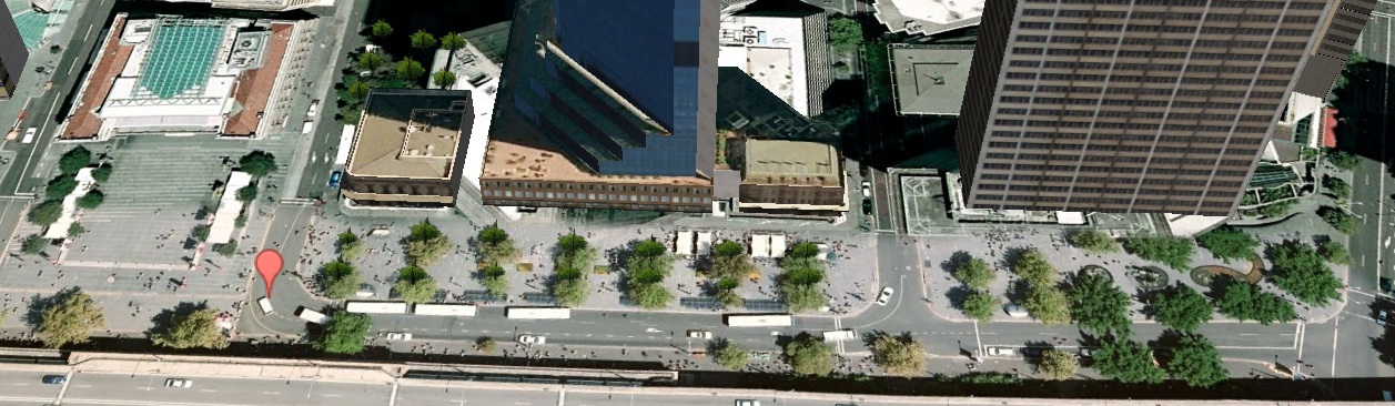
___ priority bus lane
___ right-hand turn lane
News Corp announced at the beginning of August that it would consolidate its Sydney area offices to create a central media precinct in Surry Hills. "The media precinct location provides employees with easy access to public transport links and all the amenities of Surry Hills including restaurants, bars, cafes, parks and theatres."

The corporate accounts released on Monday reveal the urgency of the moves. The newspaper advertising revenue had fallen by $US350 million and this was in addition to a $US1.4 billion write down of  mastheads and goodwill. It would not be until 9/11 2013 that they would be made aware of what the O'Farrell government had in store for them.

It is not just News Corp that relies on the right-turn lane in Chalmers Street for vehicular access from South Sydney and Botany Road. Surry Hills is still the centre for the rag trade in NSW. I bought my house in Surry Hills because family members had clothing shops in Bunbury, Perth and Port Hedland, and it was a convenient place to stay. The warehouses in Kippax Street and the surrounding area are now mainly Chinese owned but they still need access for trucks and vans. There are thousands of small businesses in Surry Hills west of Crown Street that need to be accessed from all directions.

But News Corp is the most influential of the businesses in Surry Hills. O'Farrell has seen how Rudd was treated by News Corp newspapers, on the instructions of Rupert Murdock, during the Federal Elections. He is either astoundingly brave or astonishingly stupid. He can explain what he is doing and you can decide which is the case.

Ve vill dramatically increase traffic flows in the Elizabeth Street, Wentworth Avenue arterial, then reduce the number of lanes and force Public Buses to negotiate through this traffic.

Currently there are at least two lanes in Chalmers Street for traffic to enter the critical section of Elizabeth Street between Eddy Avenue and Wentworth Avenue. Buses entering the CBD are unaffected by this traffic, having a priority lane to themselves. There are bus stops south of Devonshire Street for transfers to the railways using the Devonshire Tunnel entry to the platforms, then a stop north of Albion Street, so buses can leapfrog stops. Left-turn traffic is cleared from the bus lane by a phase in sync with right turns from Eddy Avenue to Elizabeth Street, and can turn two by two from the adjacent lane. It works impeccably. There is a separate lane for parking and right-hand turns into Surry Hills.

O'Farrell will change all this. The only access to the CBD north of William Street will be from Elizabeth Street or Macquarie Street via the arterial, throwing all the traffic from Lee Street/George Street into Chalmers Street. In Chalmers Street the bus stops are adjacent to the Dental Hospital, forcing this greatly enhanced traffic flow into one lane - the crucial right-hand turn lane into Surry Hills.
Intersection Eddy Avenue and Elizabeth Street
The RTA stopped publishing hourly traffic flow volumes in 2005 but the traffic volumes would not have diminished. The traffic volumes in Chalmers Street sampled over a week in May 2005 are on page 35 of k5sy4.doc downloadable from the Transport for NSW website. On the Tuesday, for example, the traffic flow peaked at 1420 vehicles per hour between 8AM and 9AM, was 1325 vph the following hour, and stayed around 1000 vph until 7PM. Even without additional loadings from the closure of George Street, funneling this traffic into one lane would make accessing Surry Hills from Chalmers Street difficult throughout the day.

The RTA collects vast amounts of data now and has up to date traffic flow data and the expertise to process it. We rely on the ethics of the Public Service to do what it is paid to do, and without published data to verify the problems this tramway will create, we are pretty well stymied.

Ve vont just terminate bus routes ve vill double-cross them and degrade them

Elizabeth Street bus services that are terminated at Central Station will be forced to cross the tram lines, deposit their passengers in the middle of Chalmers Street and force their way into bumper to bumper traffic in the general vehicle lane in order to make a hairpin turn around the Dental Hospital. There will be no bendy buses for South Sydney and Botany Road. There is no provision for terminated buses to wait for the start of their scheduled run and the first stop will a considerable distance south of Eddy Avenue. Then they cross the tram lines again.

The attempts of Transport for NSW to design bus/tram transfers at Kingsford and the Randwick triangle were so deliriously incompetent they were laughable. This interchange doubles the delirium. The interchanges at Kingsford and Randwick could largely be ignored and only damaged a few hundred businesses in Anzac Parade and Belmore Road.

The Elizabeth Street-Wentworth Avenue-College Street arterial is only peripheral to the CBD but is crucial to the entire Eastern Suburbs and to the southern suburbs of Sydney. The damage that O'Farrell is doing to the inhabitants of these suburbs is irreversible and can never be mitigated. The thousands businesses in Surry Hills west of Crown that depend on being accessible to customers from all suburbs will sustain losses. This is no laughing matter. A lot of pain for no conceivable gain.

Thursday 19 September 2013

Breaking news

Western Australia has had its credit rating cut to AA+ by Standard & Poors after having its AAA rating placed on negative watch after the Budget failed to address problems in funding its infrastructure projects. The report was in the business pages of the SMH but filled the front page and two other pages of the West Australian newspaper. NSW's AAA credit rating is already on negative watch.

The WA Premier Colin Barnett called for the Prime Minister, sworn in a day earlier, to 'take some leadership' and increase the GST revenue. Abbott has already told him the Federal Government will not provide any funding for urban rail projects.

In other moves NSW Planing Minister told Parliament he would delay introducing new planning laws to the lower house. This followed an admission by Planning and Infrastructure Director-General Sam Haddad that departmental staff may have unintentionally spread "inaccurate or misleading information" about the changes. This is the department that will assess the EIS for the light rail project.

Monday 16 September 2013

9/11 2013

The perpetrators

They did not know it was a suicide attack!
Gay zealot

Wanted for questioning

A dastardly attack

Barry O'Farrell launched his preemptive strike against the Eastern Suburbs on 10 months ago today, on December 13, 2012. Since then we have tried in vain to find out details that would allow independent assessments of the project. On Tuesday evening I attended a overflowing meeting to hear details of an alternative route (not the alternative route I detailed in my letter to the Minister) that had been prepared by an engineer who has worked on heavy rail projects. He had made a direct presentation to the Minister and Project officers a week earlier. At the meeting we were told that PUSH had spent more than $30,000 on advancing its case. The next day Channel 10 was preparing a report on the meeting and asked the Minister's office for a comment.

O'Farrell responded with the launch of a media blitz detailing plans to, in the words on the Channel 10 News report, remove cars from the CBD. O'Farrell had not even had the decency to communicate directly with the presenters.

Incredibly, the brochure released by Transport for NSW on September 11, entitled "Sydney City Center Access Strategy for further consultation", does not contain any more details than were given the December 13 brochure. There are however, startling revisions to the original plans outlined in the first brochure. We will outline some of these changes.

Chalmers Street Stop moved and rebadged

Original artists impression of Chalmers Street stop
Only the names on the shelters and the pedestrians have been changed

The artists impression of the stop in Chalmers Street released by TfNSW has been reproduced in countless mail drops from the Sydney City Council and Clover Moore, and shows the stop to be alongside the Dental Hospital. Bear in mind that this stop has to accommodate two cattle cars coupled together. There is bus adjacent to the eastern platform but I have tried in vain to find out in there will be a lane for general traffic.
Full size from 9 September brochure

Incredibly, the brochure released 10 months after gives no further information and is deliberately deceptive. The tram tracks are depicted by the dotted red line running along Chalmers Street, Eddy Avenue and Rawson Place. The tram stop icon is midway between the Eddy Avenue and Devonshire Street access points to Central Station and is now on the eastern side of the tram tracks, with the bus stop icons on the western side of the road.

The text says: "It is likely that only two lanes will be available for general traffic and bus operations in Chalmers Street based on the needs of light rail operations." That is to say, one lane for bus stops and one for through bus and general traffic.
Crunch point, Chalmers and Foveaux Streets

There is no possibility for Elizabeth Street buses that are terminated to turn around other than to make a hair-pin U-turn around the Dental Hospital - no bendy buses for South Sydney, Green Square and Botany. Buses making such a turn would block the one through-traffic lane. The text makes the understatement: "Further planning is being undertaken ... to confirm the appropriateness of this arrangement."

The arrow along Randle Street labeled 2 is not referred to in the text, inexplicably. It would confirm our greatest fears: that Transport for NSW wants to reduce Elizabeth Street to two lanes each way at its critical entry point to the CBD. This was apparently suppressed before the brochure went to press to prevent informed analysis of its Project. Ironically the brochure is titled " for further consultation".

Central Station Stop eliminated, stop in Rawson Place

PUSH wrote to Transport for NSW inquiring as to why there were two stops close together in Chalmers Street and Eddy Avenue. The reply was that the two stops were essential to the planning of the light rail. The foreshadowed stop in Eddy Avenue is now eliminated.

There is a tram stop at the western end of Rawson Place now, with bus stop icons in Pitt Street, Rawson Place and George Street. The text states: "Based on current planning, the light rail line will run two-way along the southern edge of Rawson Place with buses running westbound along its northern edge. General traffic would no longer operate in Rawson Place."

The reason for moving the tram stop is obvious: buses being terminated will circulate anti-clockwise allowing the bus stops to be closer to the tram platforms, as detailed in the post on the Randwick Triangle. Duh!

However the closure of Rawson Place to general traffic and the bus stops in Pitt Street will have dire consequences for Parramatta Road and City Road Public Bus services, whether they are terminated or recruited to crush the Flinders Street and Elizabeth Street bus services. These consequences will be deal with in detail in subsequent posts.

Wednesday 11 September 2013

Just passing through

Bus routes along Oxford Street have no opportunity to transfer passengers to the rail network between Bondi Junction and Circular Quay, but bus routes along South Head Road can transfer passengers to rail at Edgecliff and Kings Cross Stations. Passengers that stay on the bus after Kings Cross really want to reach destinations in the CBD north of Park Street including Circular Quay.

In the past, people would have stayed on the buses because of the difficulties in transferring to the trains but the Oyster (aka Opal) Card changes all that. In the past there was no way of dissuading passengers from staying on the buses until Elizabeth Street and walking to Town Hall Station (the most crowded station on the loop) to catch a train. The Eastern Suburbs line is the only platform not operating at or over capacity during the AM and PM peaks. The Oyster Card changes that too. The Oyster card can impose penalties on passengers who transfer from William Street buses to the tube train services but not to the Harbour Bridge trains at Town Hall Station. It can also give incentives to passengers who transfer from the Eastern Suburbs Line to other train services at Central or Redfern rather than Town Hall. The Oyster Card is truly the solution to the Public Transport congestion in the CBD.
The last stop in William Street, between Crown & Riley Streets

The last bus stop in William Street is a long way from Elizabeth Street (over the horizon in the photo) to give drivers a fighting chance to get across to the right-hand turn lanes at College and Elizabeth Streets. Buses head to Circular Quay, and to Chatswood via the Cahill Expressway during the peak periods because this is where passengers want to go. The next stop is the set-down-only stop in Elizabeth Street that traps drivers in the bus priority lane.

When the Oyster Card is operational for buses it will be possible to terminate more bus services along South Head Road at Edgecliff Station, relieving congestion in Elizabeth Street. Problem solved if no further bus routes are run along Elizabeth Street.

But O'Farrell has no intention of allowing people to go where they want to go.

Trapped in the bus priority lane
From corner with Park Street 
Bus services that run along Victoria Road have for generations entered the CBD from the Western Distributor via King Street and proceeded to Circular Quay along George Street then returned form Druitt Street. But there are efficient alternative terminuses: buses can turn into York Street to a terminus at the Queen Victoria Building, or they can enter from the exclusive bus lane running east along Druitt Street to a terminus in Clarence Street and exit from Market Street.

So what's with the double-ended mauve arrow directing Victoria Road bus services into William Street? This diagram was reproduced in the last post along with the ominous assertions about Druitt and Park Street being the main east-west bus routes.

The answer is that the invading hordes from the north are being brought into the heart of the CBD in order to herd them into the privately-operated cattle cars. Bus services from the north are given priority for the bus stops at the QVB and bus services from the Western Distributor that perforce enter the middle of the CBD are shunted into William Street.

But where will these services terminate? They cannot do a U-turn in William Street, so they must perforce continue to the bus interchange at Edgecliff Station. Alternatively buses could continue to Watsons Bay and commit suicide by driving off the cliff.
Edgecliff Station bus interchange
Entry to the bus interchange at Edgecliff Station is from Ocean Street which provides an efficient terminus for AM and PM peak bus services from New South Head Road east of Ocean Street, but involves a diabolical right-hand turn from New South Head Road for buses terminating from Victoria Road.
Bus blocking traffic

Bus stops in William Street force bus drivers to block a lane of traffic when picking up or setting down passengers as required by the contract with the builders of the Cross City Tunnel. But O'Farrell's plans for Edgecliff bus interchange will further obstruct traffic flows along New South Head Road (already operating bumper to bumper at peak times) before any one has a chance to enter the Tunnel. The SMH reported yesterday that the lenders were getting nervous. O'Farrell could be sending the Tunnel's operators into receivership for a second time. It is worth noting that the public servants who did the modeling for the Cross City Tunnel are possibly doing the infantile modeling for the light rail.
The cunning plan in continuing New South Head Road bus services to Town Hall is to feed passengers onto the cattle cars. Like, people are going to catch a bus to Town Hall then a tram to Randwick rather than drive or catch a bus there, along Avoca Street. People will be encouraged though, to transfer to the loop trains at Town Hall Station.

Tuesday 10 September 2013

How do you solve a problem like Elizabeth?

Elizabeth & Market, morning
Elizabeth & Market, evening
The intersection of Elizabeth Street and Market Street is the major crunch point for buses before they hit Phillip Street. Elizabeth Street narrows to two lanes north of David Jones to pass the historic Old Supreme Court where Ivan Milat was tried. During the morning peak buses form a continuous queue from William Street to King Street and beyond, two deep in parts. When going to appointments north of Martin Place in the morning, I have found it is quicker to leave the bus south of William Street, actually south of Bathurst Street, and walk.
Elizabeth Street buses queued to King Street and beyond
The point to note in the photos is that the buses queue in the second lane; for good reason:
BUS PRIORITY LANE ENDS
FORM TWO LANES
MERGE RIGHT
Bus drivers merge right as soon as possible after setting down passengers. If they are trapped in the kerb-side lane they move forward until a fellow bus driver lets them move in front. During the AM peak the second lane is effectively an exclusive bus lane, and the bus lanes are operating at more than peak capacity.

The Transport for NSW brochure asserts breezily that diverting all the bus services along George Street into Elizabeth Street will not create problems because they will paint an extra lane red on each side and deploy phalanxes of motorcycle police to keep traffic moving. This does not change the present situation one iota. If TfNSW is to be believed there will be no vehicular access to the CBD north of David Jones for vehicles from the Eastern Suburbs and the south, other than for buses, during bus priority  periods.

O'Farrell's contempt for the intelligence of the NSW electorate is breathtaking. There are three possible scenarios:
  1. The "Project" is a mindless, ideological attack on Public Transport.
  2. O'Farrell has a secret agenda for terminating bus services that he dare not allow to be scrutinized.
  3. O' Farrell has not got a clue as to what is going on, and is just floating along.
Or,all of the above. I will not deign to comment on what is going on in O'Farrell's mind, but will discuss the dire effects that a George Street tramway will have on whatever bus routes O'Farrell deigns to allow along Elizabeth Street.
Druitt Street north of Clarence Street
The other point to note in the photos is that most of the vehicles turning left into Market Street from the priority bus lane in Elizabeth Street are taxis. Understandably, there is negligible parking adjacent to Market Street. Parking under the Sydney Hilton, The Galleries Victoria and the new ANZ Tower is accessible only from Pitt Street which can be accessed from the east via Liverpool Street, from the west via Broadway and from the north via Bathurst Street. Druitt Street gives access to the same destinations as Market Street - Darling Harbour, Pyrmont, Ultimo and the Anzac Bridge. The Cross City Tunnel has connections only with the Anzac bridge. Taxi drivers know that all the vehicles in the bus priority lanes are turning left so in the evenings they turn into Market Street from the second lane as well, two by two.
George Street, Druitt Street intersection
Bus routes from North Sydney along York Street are spoiled for choice as to how they terminate. Some terminate at Wynyard Park, others at Queen Victoria Building, turning into the general traffic lane in Druitt Street then turning right across a bus only lane into Clarence Street for the trip back. M20 buses terminate at Botany, M40 buses terminate at Bondi Junction and M30 buses, and other routes, terminate at Railway Square. These Mn0 buses were seen as the way of the future before O'Farrell set up Transport for NSW. They are generally bendy buses, using natural gas, and more to the point they could return to the Harbour Bridge along Liverpool Street and Kent Street, which currently carries no bus services, avoiding the crush in Druitt Street (why don't they?)
Full size diagram from brochure

Transport for NSW intends to terminate all these bus services at Druitt Street in order to herd passengers onto cattle cars at the Town Hall.

The brochure lists: Key features of redesigning the bus network in the City Center

  • Elizabeth Street will be the main north-south bus route, featuring dedicated bus lanes and stopping lanes ...
  • Park Street and Druitt Street will be the main east-west bus routes, providing access for buses only between Clarence Street and Kent Street
That is to say Druitt Street will be closed for all vehicles other than buses. This will force traffic from the Eastern Suburbs needing to access destinations accessible only from Druitt or Market Streets to turn right into Elizabeth Street from Park Street then join the taxis and delivery vans queued in the dedicated bus lanes to turn left into Market Street. 

This will have a devastating impact on bus movements along Elizabeth Street and it cannot be avoided. The only access to the northern CBD grid for traffic from William Street is a right-hand turn into College Street or the right-hand turn into Elizabeth Street. The rest is inexorable.
Bound for Gore Hill, Chatswood et alia

Co-lateral Damage

The Oxford Street bus services are not threatened with termination - their passengers can never be forced to transfer to cattle cars. They are being crushed simply because they use the same route through the CBD as the Flinders Street bus routes, which must be crushed to establish the business model for the privately-operated cattle cars.

There are problems even now when Druitt Street is open for general traffic. The closure of Druitt Street makes these problems intractable. People who depend on the Oxford Street bus services will literally have no where to go.

The bus stops are widely spaced. There is a stop in Oxford Street, the next is in Elizabeth Street south of Bathurst Street and the next is outside David Jones just after the bus priority lane has ended and the road has narrowed to two lanes. There is a set-down-only stop north of Park Street for William Street bus services which is how they get trapped in the priority lane.

There is a solution to the problems if there is no tramway in George Street, that is to say, no extra routes are forced into Elizabeth Street. The solution is to reduce the number of passengers who transfer from buses to trains at Town Hall Station, which operates at over capacity during the peaks, leaving the buses to run on emptied to Circular Quay. This would be accomplished by the Liverpool Street then Kent Street bus routes.

There are currently two such services, the M40 from Bondi Junction to Chatswood via the freeway and the M30 from Railway Square to Gore Hill and there are some minor services that go all the way to Railway Square. To change destinations with the Oyster (aka Opal) Card you just get off at any stop in Kent Street and wait for the right bus - in the opposite direction you get off at any stop in York Street. The Oyster Card knows where you live and where your ultimate destination is and can impose penalties for passengers that catch a bus to Circular Quay and transfer to a Harbour Bridge train at Town Hall Station rather than transferring at Central, say, by charging for a trip to Circular Quay or by imposing a positive disincentive.

The Oyster Card collects data on source and destination on a daily basis and would identify other routes that could be profitably added to these routes, say Spit Junction to Sydney University or further along Parramatta Road or to Botany.

It turns out the solution to congestion in bus routes in the CBD at peak times lies in a late 20th century proximity-sensing electronic card. A 19th century tram system running on electricity from coal-burning solves no problems and generates mind-numbing congestion.

This will be the recurring theme of this blog.

Thursday 5 September 2013

Where's Gareth?

Stuffing up Australia's Premier City is serious business
The photo above was taken before Chris Lock, Deputy Director General, Transport for NSW disappeared into his bunker in April. Chris Lock is the doddery old fart pointing at the map, which is being attacked by his "guys" with different coloured textas. But where is Gareth? Our anonymous departmental Wiki-leaker could be anyone, even Chris Lock.

O'Farrell launched his preemptive strike, a blitzkrieg, on the people of the Eastern Suburbs on December 13th, 2012, a date that will live in infamy. There was no proclamation and no consultation in advance. Business in Anzac Parade, Kensington and Kingsford, and in Belmore Road, Randwick and in west Surry Hills and of course Devonshire Street, opened as usual on 13 December totally unaware that the O'Farrell government had been plotting in secret for months to devastate the businesses that they had built up over years and in many cases was the foundation of their superannuation.

They would not be told until April the next year that the O'Farrell government would not respond to any criticism of the "Project" and would not allow any changes. Subsequently, all attempts to obtain more details, even using "freedom of information" requests and Questions with Notice in Parliament, were met with the response that a brochure containing the deliberately vague maps shown in the header, had fully disclosed the Government's plans.

Within two days of the release of the brochure, on December 15th, Gareth made a revision to the Wikipedia article on Anzac Parade, inserting the information that the O'Farrell Government would be proceeding with the light rail project. Seven minutes later, WWGT (an acronym for Wrong Way Go Back) deleted two bytes. Wikipedia uses a global clock to archive revisions. They evidently work in the same office - is WWGB Gareth's supervisor? And they evidently work for Transport for NSW. They have leaked information on the names of stops and other things, that had not been made public, and the information has proven chillingly correct.

On 30 June, Gareth was activated again, setting up a new article on the CBD and South East Light Rail. Since then Gareth and WWGB have made 13 revisions, taking down information that challenges the department's assertions and leaking additional speculation from the department. Information on the history of light rail projects in the article is patently untrue, but hasn't been taken down.

Gareth and WWGB have made contributions on other articles about light rail over the last few years. Public Servants spend a lot of time with absolutely nothing to do. They are light-rail zealots and they work for Transport for NSW. There is nothing wrong with being light-rail zealots, but they work for Transport for NSW, i.e., they are deliriously incompetent.

Tuesday 3 September 2013

The Reichstag Fire Stratagem

Up Yours too
VE VILL BLAME BUSES FOR THE CONGESTION VE ARE CREATING
THEN VE VILL TERMINATE THEM

The brochure Sydney's Light Rail Future states: "Most people arrive in the CBD via public transport. This means we can see 370 buses moving along George Street outside Town Hall in the morning's busiest hour - creating congestion. It can take up to 30 minutes to get from Central Station to Circular Quay, a distance of 2.5 kilometres."

Fortunately Chris Lock is a self-proclaimed genius and has come up with a solution to all this: transfer all the bus routes using George Street into Elizabeth Street! Not only will the buses from Parramatta Road and City Road have to deal with the extra buses from Oxford Street, William Street and Chalmers Street, they have the extra established congestion points in Elizabeth Street at the right-hand turn from Liverpool Street and the left-hand turn into Market Street. Then they have to deal with the congestion and restricted bus-stop space in Phillip Street.

O'Farrell's contempt for the intelligence of students and staff at Sydney University and University of Technology and for the intelligence of residents in southern and the inner western suburbs of Sydney far exceeds his contempt for the intelligence of residents of the Eastern Suburbs.

In the past there was no way of dissuading commuters on bus services along Broadway from catching a bus to Circular Quay then getting off at Central Station, so, in general, all bus services proceeded on to Circular Quay. That has changed now, and this was explained to the Minister for Transport. She has chosen to ignore this advice and is proceeding with a catastrophically flawed "Project", with the support of O'Farrell.

Transferring bus services using Broadway from George Street to Elizabeth Street achieves nothing, of course, and makes it impossible to ever reduce congestion in the CBD.

Monday 2 September 2013

A tram system based on a rank fabrication.

Circular Quay George Street bus terminus
The Deputy Director General of Transport for NSW, Chris Lock, addressed a Randwick Business Breakfast in April. Sorry to keep harking back to this meeting, but it was the last time he was seen in public. He made a blunt assertion to the attendees: "Over the two hours of the AM peak, 1610 buses arrive in the CBD, some 200,000 people rock up into the CBD ... there are 190 individual bus routes that arrive in the CBD. And to put it bluntly, we have run out of real estate".

He added: 'Fortunately I am a simpleton so I will solve this "problem" by halving the amount of real estate!' OK, he did not say that. He is not intelligent enough or self aware enough to make such an observation.

In fact, Transport for NSW is reducing the amount of "real estate" by much more than half. In a transport system "real estate" is curb space, and less than half the curb space available to the George Street and Castlereagh Street bus services is currently being utilised. Bus stops are placed on only the southern side of Alfred Street, with buses using Castlereagh Street turning into Pitt street and George Street buses turning efficiently into George Street. The northern side of Alfred Street is used by taxis waiting for passengers to turn up. Bus stops for the Surry Hills and City Road bus services using Castlereagh Street can be located on the northern side of Alfred Street, and ultimately the taxi ranks can be relocated for more relaxed transfers onto George Street bus services using the same clockwise and anticlockwise arrangements used for the Phillip Street terminus which is much more pressed for "real estate".

The Transport for NSW solution for its declared "CBD bus problem" is to give bus services from southern Maroubra, Malabar and Little Bay, which currently account for a small proportion of the bus services using the northern side of the Phillip Street terminus, all the "real estate" in Alfred Road to the west of the Customs House. We can put figures to this. During the fabled 2 hour AM peak, presumably from 8am to 10am, when we are told 1610 buses arrive in the CBD; 34 buses will be using all the "real estate" to the west of the Customs House to the exclusion of all other services.

Six of the 190 bus services that enter the CBD will have exclusive access to Alfred Street west of the Customs House. All the bus services from Parramatta Road, City Road and South Sydney will be forced into the Phillip Street maelstrom where they will compete for "real estate" with buses from the North Shore and Barangaroo.

The attempts by Transport for NSW to integrate the cattle cars with the bus services are so incompetent, it will be forever thus, particularly when the full horrors inflicted by the trams are evident to all.

The Circular Quay bus terminals have enough "real estate" to deal with the CBD public transport for the foreseeable future. It is possible to reduce the number of buses going all the way to Circular Quay, and the Transport Minister has been informed how to do this. Trams down George Street will in fact make it impossible to do this.

The eye of a needle

The one and only Bus Corridor (green)

The brochure released on December 13th, 2012 contains the figure left, reproduced in full size. This diagram is deliberately deceptive, like most of the diagrams in the brochure. The arrows show only outbound bus movements concealing the fact that northbound traffic into Elizabeth Street and Wentworth Avenue from Chalmers Street will be reduced to one lane at most and probably no lanes. Traffic flow in Foveaux Street appears to be reversed. The greatest deception is the the corridor is shown to be the same width for its whole length. In reality, Phillip Street, from Hunter Street to Circular Quay, is only four lanes wide, and always will be.

The trams will only ever carry, voluntarily, off peak passengers from the Prince of Wales hospital and the University of NSW. To establish a business model, the privately-operated trams must crush the public bus services. This occurs for bus services using Anzac Parade primarily in Anzac Parade, but for other bus services, as well as Anzac Parade services, it occurs mainly in Phillip Street.
Phillip Street bus terminus
Buses that have a terminus from Phillip Street circulate clockwise, setting down passengers in Young Street, waiting if necessary for their scheduled start, in Young Street then picking up passengers on the north side of Alfred Street. Alternatively, the buses circulate anti-clockwise, setting down passengers in Phillip Street and picking up passengers on the south side of Alfred Street. In general Flinders Street buses circulate anti-clockwise and the rest circulate clockwise. This arrangement is necessary because of the limited curb space available in Alfred Street east of the Customs House.

O'Farrell would have you believe that all the bus services using George Street and Castlereigh Street will be terminated at this Phillip Street terminus as well as the existing services, and services from the north shore using the Cahill Expressway. O'Farrell's contempt for the intelligence of residents of the Eastern Suburbs knows no bounds.
Up yours
Ve vill tell everyone they vill be going to Circular Quay
then ve will terminate them at secret locations