Wednesday 31 July 2013

The impossible bus/tram interchanges.

Indicative only map from June 21st Significant Infrastructure Application
I am not aware of any road in Melbourne that carries both trams and buses, but then the Melbourne transport system was not designed by a self-proclaimed genius. The map above is from the Significant Infrastructure Application supporting document, released on June 21st, three weeks after the anonymous Department contributors leaked the names of the dots in the Wikipedia. This document is a legal requirement for an EIS and is available on the Transport for NSW website. The grab above is full size so the lack of discernible detail is quite deliberate.

We cannot say anything about the Carlton Street dot except the this is one of the crunch points that force all vehicles into the bus lane. We can note that the Todman Avenue dot is a long way south of its namesake, the horizontal white line, and the UNSW dot is midway between Day Avenue and High Street. This is inevitable. The one the only bus-and-every-other-vehicle lane must swerve around tram stops and hook-turn lanes, bus stops, loading bays, local short-term parking bays, set down bays for students driven to Uni, taxi ranks and service vehicle bays, ducking and weaving more often than an eco-nazi on the Randwick City Council. The kerbside lane beside the tram stop becomes the hook-turn lane and if this is not long enough to cope with the worst-case scenario then through traffic is blocked. Unfortunately the tram stops will be set in concrete and unable to cope with changed circumstances.

Bus stops are traditionally placed adjacent to cross roads, for obvious reasons: passengers who do not live or work directly on the route can use the footpaths of the cross road to reach the stop, rather than clambering over fences and rooves. If placed before the intersection, buses can be allowed to jump the queue of vehicles waiting to pass through the intersection, as at Taylor Square:
Queue jumping bus lane

Hook turns put an end to all this. Bus stops must be placed after the intersection. Even if bus passengers became frustrated with interminable congestion in the bus lane and left the bus en masse, and trekked back over the pedestrian crossing, over the length of the hook lane and over the extra pedestrian crossing, and transferred to a tram, the bus would have to carry on empty to the terminus because hook turn lanes prevent buses turning around.

The anonymous Transport for NSW authors of the Wikipedia article referred to the Kingsford and Randwick dots, the two termini, as possible bus interchanges which distinguishes them from all the other dots, which are impossible bus interchanges. They have now changed this description to future bus interchanges. That is future as in after the Environmental Impact Statement.

Sunday 28 July 2013

The Kensington Wedgie

Kensington is defined by two of Sydney's most important arterial roads, South Dowling Street on the western boundary and Anzac Parade that passes thought the eastern side. The internal grid roads once connected to South Dowling Street but now terminate in a single lane feeder road, Samuel Terry Ave., running down from Todman Avenue. If you miss the left turn into Todman Avenue you are at the Domestic Airport before you can turn around. I am pretty sure this predates the Eastern Distributor. I caught a taxi to the Australian Golf Course in the 1980s and the driver could not find the entrance. He drove to Mascot and back and would have repeated the manoeuvre if I had not yelled at him to turn into O'Dea Avenue.

To reach destinations in Kensington from Eastern Australia from Kirribilli to Cape York you have a binary choice: you can turn left into Todman Avenue from South Dowling Street or right from Anzac Parade. I don't have off-street parking and there is a steep gradient so the bike is easy to knock over, so I arranged to leave it at a carport at a unit in Lenthal Street while I was in Broome. I missed the right-hand turn from Anzac Parade to Todman Avenue so I got to find out how far one has to go to turn around in Anzac Parade. I was able to make a right-hand turn into Day Street at an intersection without traffic lights just south of NIDA.

Day Street is the boundary between Kensington and Kingsford and is the only street distributing traffic to the whole of the Kingsford grid so this is an important right-hand turn. Without this turn all traffic to Kingsford from the north would have to turn into Todman Avenue and pass through Kensington. And the turn into Todman Avenue has enough to deal with. Satellites pass overhead at all different times so Google Earth choses times around noon, when there are less shadows, for their snapshots. The screen-shot above was not in the morning or afternoon peaks, but the right-turn lane, which stretches an entire block, was full of vehicles during the traffic-light phase in operation at the time of the snapshot.

In roads without tram lines right-hand turns take place simultaneously during the same phase or take place with only one direction blocked. However, hook turns where more than two or three vehicles typically turn right during a traffic-light phase, require separate right-turn phases for each direction, when nothing else moves.

So we can deduce that the right-hand turn at Day Street will be retained. Unfortunately hook turns at intersections without traffic lights are really scary. The driver must wait for a simultaneous gap in three lanes of traffic and two tram lines carrying, we are told, trams in each direction every two or three minutes. So the intersection will need traffic lights, and the hook turn will block both directions of traffic.

We can also deduce that the dot called University of NSW, NIDA will indeed be south of Day Street wedged between the buildings on each side of Anzac Parade. It will be a fair distance south to allow a left-hand turn lane into Day Street and will need its own pedestrian crossings.

We are in a position to assess the damage O'Farrell is inflicting on the public bus services along Anzac Parade:

  • Two lanes of vehicular traffic forced into the one and only bus lane.
  • At least one extra traffic lights controlled intersection.
  • Traffic flow impeded by hook turn phases throughout the length of Anzac Parade.
  • Extra pedestrian crossings at each tram stop.

Saturday 27 July 2013

The Hook Turn


Hook turn from Elizabeth Street to Lonsdale Street east
People ask if trams are so great why were they removed from road systems throughout Australia, and burned in a bonfire of vanities in Sydney, in the 1950s? There is a short sharp answer to this: the hook turn.

Tram lines require vehicles to make right hand turns from the kerb side lane. The screen shot above shows vehicles making a hook right-hand turn in the Melbourne CBD. There are 25 intersections in the Melbourne CBD where hook turns are necessary - they are listed at this web site gps-data-team.info. The intersection of Elizabeth Street and Lonsdale Street had a hook turn in progress as the satellite was passing overhead so it will be used to demonstrate the principles of the turn. Traffic turning left or right share the kerbside lane. The main streets are so wide in the Melbourne CBD that up to three vehicles can wait to make a right turn without blocking traffic making a left turn in concert with the straight through traffic. The Road Rules of Australia require right turning traffic to wait for the cross street traffic lights to turn green before completing their turn - the cross-street traffic will wait for them to make their turn before setting off. If there are more than three vehicles wanting to turn right during a traffic light phase they must wait behind the pedestrian crossing until the next phase, blocking left and right turning vehicles alike.

 If straight-through traffic was also blocked this could lead to grid-lock. However there are further Road Rules to minimise the likelihood of this happening. Drivers are proscribed from driving past the back of a tram that is stopped at a tram stop, so passengers typically disembark and embark from trams onto the road tarmac, and vehicles can swerve onto the tracks so long as they do not queue in tram lanes at intersections.

The Australian Road Rules basically assume that there will be only two or three vehicle wanting to make a right-hand turn in each direction during each traffic-light phase. The Melbourne road system achieves this by directing most vehicular north-south traffic in the CBD into King Street which has no hook turns. Arterial roads such as St Kilda Road, which has tram lines along the centre, has a minimum of two lanes in each direction and has no hook turns. The Road Rules of Australia were not designed to cope with tram lines down the centre of a crucial arterial road.

Monday 22 July 2013

Connecting the dots

Transport for NSW has released two documents about the Light Rail Project. One was the brochure released when the Project was announced in December, which contained gibberish, jargon about Stakeholders and Round Tables and infantile modelling. The second document was released on the 9th of April 2013 and is called Industry Briefing Session and can be downloaded from their website. This document is much more informative.

We can deduce the design of the tramway in Anzac Parade from this document and can assess the impact of the tramway on traffic movements in Anzac Parade and in the whole of the South Eastern Suburbs. The diagram above indicates the design of the tram stop between the University of New South Wales and NIDA. Things to note are:

  • All traffic including buses are funnelled into one lane each way as in George Street.
  • There are head-high pedestrian barriers right left and centre to shepherd passengers into the cattle-cars.
With making deductions you run the risk that the designs can be changed in the face of criticism and wide-spread Public anguish. Don't laugh, this has already happened. The brochure released in December showed a dot between Riley Street and Crown Street, and the dot was subsequently given the name of Devonshire Street, Ward Park. Now our Wiki-leakers refer to this dot as Surry Hills. It is impossible to deduce where this dot will end up.

However there is very little wriggle room between the University of NSW and NIDA as you can confirm with Google Maps. The sheer glass foyers of NIDA are built on the street boundaries and University buildings are on the boundaries.
Anzac Parade currently operates with two vehicle traffic lanes in each direction with potentially one tidal-flow bus priority lane in each direction. The bus priority lanes are used for short term parking for local businesses in off peak periods. The tramway forces the two lanes of vehicular traffic into the bus lanes, twenty-four hours a day, forever. If a traffic artery is reduced to one lane at any point it is reduced to one lane for all of that length.

We will assess the impacts of running a tramway along a vital traffic artery with all the data that is currently available. The Road and Traffic Authority has more up to date data and can run Apps with this data, but O'Farrell will not allow the RTA to do modelling of traffic flows around tram stops.

Friday 19 July 2013

Fasten your seat belts...

The Minister for Transport and the Deputy Director General of Transport for NSW, Chris Lock, attended the Public Meeting at Sydney High School on Tuesday, 15th April. Since then the Minister has refused to answer any Questions on Notice in Parliament and has refused "Freedom of Information" requests on the Light Rail Project. Chris Lock attended the Randwick Burghers Breakfast later that week and since then he disappeared in his bunker and all attempts to obtain more information have been met with the line he used at the meeting: "Alignments are still being determined - you will see surveyors in your streets".

The Government is trying to suppress any informed discussion of the Project until the EIS is released. Then it will be able to present the Project as a fait accompli and Infrastructure NSW can do what it was set up to do and rubber stamp the Project before the Public has had a chance to make an assessment of what will be happening to their City.

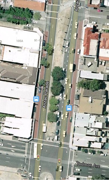
However there has been a Wiki Leak! Gareth and WWGB put names to the dots along Anzac Parade in their article in Wikipedia. With this information we will be able to commence an analysis of the consequences of the Project for businesses, residents and suburbs affected by the Project with all the rest of the information that is available. The consequences are dire for just about everyone in the Eastern, South Eastern, Southern and Inner-western suburbs of Sydney. As more information is released we will refine the conclusions.

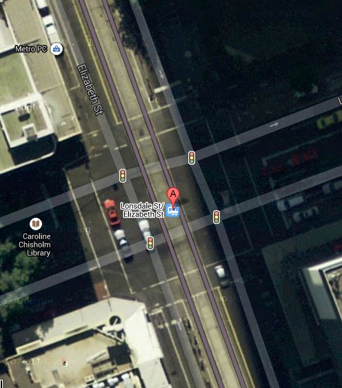
So little information has been released we have to make deductions about the Government's plans. We will lay out the grounds for making these deductions so you can make your own assessments as to the validity of the arguments. Google Earth was developed in Sydney and the intellectual property rights are still in Australia. Without these rights Google would pay hardly any tax in Australia despite having 90% of the search traffic, but that is another matter. Google Earth is a magnificent facility that is available for free the every person in the world. I will be using screen shots from Google Maps, such as the one below, to develop the arguments, but you can use the facilities provided by Google to dynamically assess the validity of the arguments (or otherwise).
NIDA  / University of NSW
We live in an age where everyone has an opinion no matter how ill informed, and you can find an "Expert" to tell you anything you want to hear. It is important for every citizen to take the trouble to make up their own mind. Traditionally with the Westminster System of Government you elected someone to be fully informed and make decisions on your behalf, but the political processes in NSW have become so debased that it is a duty of citizens to follow arguments and become well informed on matters that affect them and their communities.

I came to grief downloading Google SketchUp. The site came up ahead of Google in a Google search but the warrant had expired. Mac OS X would not open the App as it was outside the security settings but a trojan escaped none the less, don't ask me how. The password of my administration login was changed, evidently by a Chinese hacker. This is remarkably easy to do - U-Tube is awash with videos showing how to do this with a few lines of java script. Mac OS X picked up that the password had been changed without using the old password, bless them, and transferred my files to a guest login, and I was able to trash the recent downloads and the virus. I had bought one of the first of the new iMac Air to reach Australia and the administration password is in firmware so only an Authorised Reseller can reset the password.

But I am back on the road and can put rubber on the road as Chris Lock is fond of saying.

"Fasten your seat belts you're in for a demolition derby."

Thursday 11 July 2013

It is not just me

Member for Sydney
On a Round Table, out of the loop.
I went along to the Light Rail Community Forum at the end of April in good faith. We had been promised that there would be information about the Light Rail through Surry Hills. Instead we were handed the brochure released when the Project was announced and we were told by the Deputy Director General at Transport for NSW, Chris Lock, that no changes were possible, there would be no information on impacts on Surry Hills as surveyors would be working on alignments and he kept spouting jargon about "Round Tables" and "stakeholders". He kept chanting assertions that were clearly untrue. A TV News report on the meeting is in the bottom bar.

I could not sleep after the meeting and set about writing a letter to the Minister for Transport, my third letter ever to a Minister of the Crown, pointing out the obvious flaws in what Chris Lock had said at the meeting and in the infantile modelling exhibited in the brochure. I revised what I had written the following day and roamed the mean streets of Surry Hills to confirm the practicality of what I was proposing, and posted it off.

Chris Lock attended a Randwick Business Breakfast later in the week to give an address on the Light Rail Project. He chortled disingenuously to the breakfasting burghers of Randwich that he had been to a meeting in Surry Hills earlier in the week: "There are winners and losers and we all have to deal with this in our day to day businesses and politics and so on and so forth. The Minister was very clear to say if you happen to be a person who lives on Devonshire Street, we are very sorry, we are sorry, it is going to be nasty for a while." These were not the Minister's words, and they are not only disingenuous they are specious. The changes Chris Lock is making to the road systems of Sydney are not for a while, they are irretrievable.

It takes a while for emails and letters to a Minister to percolate through the system and Chris Lock would not have bebusen aware at the Breakfast that he had a lot more to be sorry for. Make no mistake, Chris Lock is a nasty little shit, and he does not care how many businesses or jobs he destroys so long as he can sell his Project to a private consortium, but he was not intelligent enough to realise that there are a lot more losers than the people who live in Devonshire Street.

In fact almost everyone who lives in the Eastern Suburbs, the South Eastern Suburbs and the inner Western Suburbs or lives or works in the CBD of Sydney will be very seriously disadvantaged by the Project. I will list the two irretrievable consequences of the Project that will impact the most people:
  • Every traffic artery from the Southern and South Eastern Suburbs of Sydney to Eastern Australia, from Kirribilli to Cape York, will be narrowed to one lane, or none, 24 hours a day, 7 days a week, 365 days a year till the end of time.
  • Every bus service to the Sydney CBD will be severely degraded.
The Minister received letters from other people who have also contacted PUSH. After the Breakfast Chris Lock and the Minister for Transport retreated to their bunkers and have not answered any further questions about the Project or given any further addresses. Attempts to use "Freedom of Information" requests have been rebuffed on the grounds that the brochure gave full disclosure of the Project.
When the Daily Telegraph reported that my local Member of Parliament had been invited to join the Light Rail Round Table I emailed him to ask him to use his position to obtain information about the Project. His Electorate Officer has replied that unfortunately we do not know any more than the general public. O'Farrell is showing the same contempt for Parliament as he has for the people of New South Wales. I include a link to my email and the reply here.

Thursday 4 July 2013

The Phoney Wars

Ve vill fight them in the trenches at Sydney High
Ve vill occupy 2/3 of ANZAC Parade
Ve vill never allow traffic impact assessments

O'Farrell campaigned at the state election with a promise to assess the possibilities for Light Rail in Sydney. The photo above was taken by the ABC when his electoral victory was declared. On assuming power, after 17 years in the political wilderness, he did the opposite. He methodically subverted the NSW Public Service.

He set up two new government departments that had not existed before and gave them the authority to ride roughshod over the traditional Public Service departments. The two departments were Transport for New South Wales (TfNSW) which would develop an existing rejected design, and Infrastructure New South Wales which would approve the Environmental Impact Statement. The Roads and Traffic Authority would not be allowed to do modelling of the traffic flows around the tram stops and the impacts on traffic arteries and adjacent roads, using its formidable data bases and mathematical expertise. And so, between the two of them, the new departments would, as the saying goes, lick the arse crack clean.

There was a problem though. Infrastructure NSW made an informed assessment of the Project and gave a damning rejection of the underlying assumptions. The comment in the side bar is one of the least damning comments that were made. And so, O'Farrell announced the mass resignation of the inaugural chairman Nick Greiner, a former Liberal Premier, and the chief executive Paul Broad of Infrastructure NSW on May 23. Greiner was replaced as chairman by a Liberal Party henchman, the former Business Council of Australia chief Graham Bradley yesterday, and TfNSW appear to have no qualms about ever having to justify the infantile modelling which is being reiterated in the Wikipedia article.

Wikipedia is a not-for-profit altruistic organisation that relies on donations from the public to offer free access to reliable information and it is sad that a Government department should employ people to subvert the editing process. TfNSW is devoid of any ethical compass. Gareth and WWGB have their identities protected by Wikipedia but it is clear that they are embedded with TfNSW and have a day job there. While the name of the Surry Hills dot is being repressed the three roughly equally spaced dots in Anzac Parade have now been given names.

Tuesday 2 July 2013

Wiki Wars

There is a new article in Wikipedia started by Gareth on the 1st July on the CBD and South East Light Rail. It is well researched and apparently written by a public servant with a lot of time on his hands. The article reiterates the cost of the project given by the government of $1.6 billion. I added the information that the announcement of the Project did not reveal where workshops for the trams would be located. Clearly the workshops would have to be taken into account for Treasury to estimate the cost. Within a couple of hours a contributor WWGB successfully applied to undo the comment on the grounds of insignificant detail.

Gareth and WWGB cannot remove details from Google servers so we will expand on the topic of the workshops. Restoring the tram workshops at Circular Quay would require the demolition of that building designed by Jan Utzon, which would be prohibitively expensive, and there is no space for them in Randwick, on the small traffic island outside the Prince of Wales Hospital. So it looks like South Sydney Leagues Club will be getting workshops on its car park in front of the Clubhouse. This is hardly an insignificant detail for its members and they deserve to be informed before being confronted by an Environmental Impact Statement. Residents in Kensington would also have an interest in the location of a noisy industry in their suburb.

It is almost six months since the State Government made the unheralded announcement of the Project and there is still no details other than lines of dots on two road maps. The Wikipedia article has less information than has been revealed subsequent to the announcement! The dot in Surry Hills shown in the original brochure has been given the name Devonshire Street/ Ward Park but in the article is referred to as Surry Hills. All attempts to correct this have also been undone.