Saturday 28 June 2014

The above-surface Foveaux Street connection

Moore Park Bus Roadway exit
Buses exiting from the Moore Park bus roadway, which was originally a tramway, go one of three ways:

  1. Along Flinders Street to Oxford Street and Liverpool Street to turn into Elizabeth Street
  2. Onto the Eastern Distributor to Bent Street to turn into Elizabeth Street southbound
  3. Along Fitzroy Street and Foveaux Street to Elizabeth Street
The Foveaux Street route sets down passengers transferring to Central Station in Foveaux Street and continues north along Elizabeth Street. It is used for services that have insufficient catchment for separate services to Railway Square and Circular Quay to be viable, such as services to Clovelly. The 13 Dec 2012 brochure announced that the trams would remove 220 buses from the CBD in the morning peak and had figures showing bus volumes on approach roads before and after the advent of the trams. The buses along Foveaux Street were to be obliterated. These routes did not go within cooee of the tram terminals so it was impossible to to ascertain how this would be achieved. There is still no information on what fate the North Shore politicians have in store for the residents of Clovelly and northern Coogee. Their MP Notley-Smith was in on it but has no concern for his constituents.

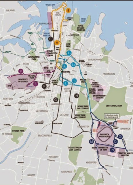
There were never trams along Foveaux and Albion Streets - they were to steep. Trams to Randwick and along Anzac Parade went along Oxford and Flinders Streets. When buses replaced trams they followed the established tram routes which were marginally shorter than the Foveaux Street route, but not shorter in time during the AM peak because of overcrowding of the right turn from Liverpool Street into Elizabeth Street northbound. A tram service in parallel with the bus road (orange line) and using the Campbell Street connection would be so superior to the Flinders Street bus services - the trams avoid the Liverpool Street turn, the congestion at Market Street, the mother of all pinch points between the Old Supreme Court Building and the St James Centre and the congestion in Phillip Street. They would all but replace the Flinders Street bus services to the northern CBD. The trams and buses would switch lanes north of South Dowling Street.
Taylor Square Tram tracks
The inbound rails swing round the old Commonwealth Bank building, now garrishly painted. The remaining Flinders Street bus services could use the tram lane - there is ample space for buses to queue at the intersection to go round the corner to the stop in Oxford Street (there is no reason to allow taxis, bicyclists and motorcyclists to use this lane). With Flinders Street feeding fewer buses into the mother-of-all pinch point in Elizabeth Street more bus services would use the Foveaux Street route to Elizabeth Street. This has the advantages of relieving congestion in the Oxford Street bus route to Circular Quay at Liverpool Street and at the mother-of-all pinch point in Elizabeth Street southbound - the southbound route is along Castlereagh Street. Also, this route picks up passengers from Central Station on the northern side of Eddy Avenue reducing the need for bus services from the southeastern suburbs to the Lee Street layover (Railway Square).

The outbound tram alignment
The outbound tram rails (red line) go along Bourke Street to Albion Street with stops south of Campbell Street and north of Albion Street. Campbell Street is one-way east of Crown Street and Bourke Street is one way north of Albion Street.

Whichever route buses take to Elizabeth Street they all return to the southbound busway via a bus lane from Albion Street to Moore Park Road. The outbound trams would share this lane. The distance of the shared lane is less than the distance of shared lanes from The Strahan Street stop to the Kingsford terminus. The indicative plan of Parsons Brinckerhoff showed buses wafting into this lane at random intervals from one of the two narrow parallel general traffic lanes. I objected to this in posts on this blog and in my submission to the EIS. The dotted lines on another figure do not reveal right hand turns to Bunnerong Road will be from the shared lane and movements on this shared lane are complicated by a right turn into Gardeners Road for general traffic - vehicles that encroach onto the alignment will be run down by trams with priority signalling just like buses. "The Secretary" did not deign to comment on these matters in his Assessment.

In Flinders Street entry to the shared lane would be controlled at traffic lights and priority to buses and trams in the final section east of South Dowling Street over entry from left turning traffic would be implemented by the traffic lights at this intersection. Presumably the world famous SCATS system could coordinate the traffic lights at South Dowling Street and Moore Park Road.

The bus stop in Flinders Street between Albion and South Dowling Street would be moved to north of the pedestrian crossing on the northern side of Albion Street. There would be no tram stops between the southmost stop in Bourke Street and an ARL Central stop south of Moore Park Road.

The red line in the top figure shows the route of the outbound shared lane. Inbound trams and buses would cross Moore Park Road in parallel. Buses would separate to the right from the shared lane shortly after entering Moore Park and return to the southbound busway:
The return to the Moore Park busway
Inbound trams would cross this bus path after leaving the ARL Central stop in order to cross Moore Park Road in tandem with buses. The ARL Central stop would be located on a denuded strip of park used to access parking when events are held. No mature trees would be harmed in the alignment.
No mature trees are harmed in this tram alignment
It may not be necessary to move the historic sandstone gateposts depending on how accurately bus drivers can align their buses.
The entry to the busway
Doomed pedestrian/bicycle crossing
Pedestrian Crossings
Which brings up the question of what happens to the pedestrian and bicycle crossing of the bus way on the southern side of Moore Park Road? Its fate has already been sealed by the Baird Government. Permitted pedestrian and bicycle movements have been published. To get between the stadium precinct and Surry Hills you will have to use the snail-shell spirals of the overpass or cross Moore Park Road to the east of Flinders Street and cross Flinders Street on the northern side of Albion Street.

The busway is closed because of work on this overpass designed by TfNSW and overwhelmingly objected to, even by the North Shore Tea Party hatchet man Tony Shepherd. There are conditions that there will be no construction on the light rail project until some details of the CBD bus plan are released, that is to say until after the State Election on 28 March 2015.

The crossing at Moore Park Road would remain closed with the Flinders Street tram alignment. The only pedestrian crossing of the shared tram/bus lane would be the existing crossing on the western side of South Dowling Street. The EIS for the Eastern Distributor showed a bus stopped at Drivers Triangle. I pointed out that anyone who alighted here would have nowhere to go except to jump into the on-ramp to the the Distributor and it did not go ahead. So restricting pedestrians to this one crossing makes sense.

Thats it folks
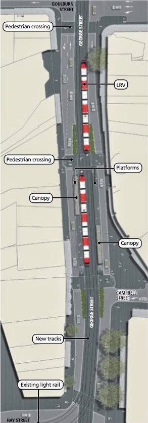
This relatively short post has described the Flinders Street/Campbell Street tram track alignment in more detail than the George Street alignment has been described in an unbelievably voluminous Environmental Impact Statement (the public servants at Transport for NSW and their highly paid consultants have a cloying need to be acclaimed as geniuses), a never exhibited Preferred Infrastructure Report and an inane Secretary's Environmental Assessment Report (who the hell is this all powerful Secretary). The description has no deliberate contradictions; nothing has been cropped or withheld. The description is the same as outlined in a letter to the Minister more than a month before the Project was declared to be critical State Significant Infrastructure.

It ain't over until the fat turd* sinks
*Colloquially a Floatie
The Baird government will not begin construction on the Project until after the State Election on 28 March 2015. I have no idea if contracts can be signed before then, but contracts can be broken. Neville Wran cancelled contracts to build carriageways over Darling Harbour and went on to record Wranslide election results.
The people of NSW dodged the bullet in 1976 but now we are facing a cannon.

Baird has said that if his government is elected for the first time he will consider it a mandate to sell city power poles and wires supposedly to build at any cost projects that only benefit the North Shore and have not been designed, costed, subjected to a cost-benefit study or been subject to a feasibility study. The projects exist only as a line of dots on crudely drawn maps and the dots change with every press release. Here we go again. The age of entitlement for the North Shore is just beginning.

Projects will be declared to be critical State Significant Infrastructure to avoid any independent scrutiny.

The election on 28 March 2015 will decide the future of the City of Sydney

Wednesday 25 June 2014

The Campbell Street connection

Buses from Parramatta Road and City Road have to travel north at least to Campbell Street in order to physically turn around. It does not make any sense then for trams to access the CBD south of here. Running coupled 90 metre long trams through the three major pedestrian crossings from Central Station and blindsiding pedestrians would not be acceptable anywhere in the civilised world. It is also completely unnecessary. If trams from the southeast enter the City to the north, the Randle Street loop that worked impeccably during the Olympics and at events ever since remains virgo intacta. The trams are an additional resource for clearing the crowds. It is Baird's obsession with crippling the Public Transport system and forcing people onto privately-operated transport that is the sole motivation for this disastrously misconceived tramway.
Connecting Campbell Street trams to the Pitt/ Castlereagh Street loop
I outlined how trams from the southeastern suburbs would connect to the Pitt/Castlereagh Streets tram loop in my letter to the Minister more than a month before Hazzard declared the undeveloped Project to be critical Significant State Infrastructure. The tram rails are side by side in the lower part of Campbell Street west of Hunt Street and occupy the redundant left-turn lane in Campbell Street and then some to the east of Hunt Street. Outbound buses would access Crown Street by travelling straight up Goulburn Street which is now one way all the way, east of College Street. The tram tracks in Campbell Street do not obey the drive on the right rules which is of no matter since the tracks are isolated from pedestrians for most of the route and would have an appropriate speed limit for this limited distance.

Inbound tram services
Campbell Street westbound west of Elizabeth Street is just a rat-run for vehicles that choose not to use Eddy Avenue or Hunt Street to reach Pitt Street or George Street. It would be closed to vehicular traffic other than trams east of Pitt Street and buses to the west.
Campbell into Castlereagh thence Central Station 

Campbell at Elizabeth Street
There would be separate tram services from the southeastern suburbs to Central and Railway Square and to the northern CBD, as has been the case from the foundation of European settlement in Sydney. The width of the roads in the northern CBD was predicated on this policy.

Because the rails do not obey the keep to the right rule there would be inbound stops at Taylor Square and say Harmony Park. There would be no right turn from Campbell Street into Elizabeth Street just a left turn. Vehicles including buses would use Hunt Street to make this turn - there are no destinations between Campbell and Goulburn Streets.

In a previous post "Managing congestion with the Oyster (aka Opal) Card" I outlined how the Opal Card can mitigate congestion in George Street bus lanes north of Market Street in the few hours of a week day when this is a problem. This is the case even if there are no tram tracks to the north of the CBD. With the Pitt/Castlereagh Streets tram loop restored there is a fourth terminus in the CBD for Parramatta Road and City Road bus services. Buses can terminate at Campbell Street, making a left turn from Pitt Street. Passengers can transfer to Loop, southeastern Suburbs and Lilyfield Line trams by crossing Campbell Street to a stop in Pitt Street. Buses terminating here cross the Lilyfield rails coming and going but they do not cross tram tracks a mind-numbing five times while running on empty after dumping their passengers in Pitt Street, as proposed by TfNSW. This terminus does not offer opportunities for buses to lay over and would mainly be used during the AM peak. The cost on the Opal Card would be the same as for a service to Randle Street. With the Opal Card commuters can change to a service to the appropriate destination at any stop in Parramatta Road or King Street as pointed out in the previous post.

Most tram services from the Lilyfield Line would continue to the north of the CBD but there would be the usual choice of destinations to Central Station. Off-peak services would stop at Central on the way north.

The Loop tram services add additional capacity to transport services to the CBD and do not degrade any existing bus service. They make Sydney CBD transport future-proof.

Outbound tram services
The outbound tram rails are through the "Golf House" building and the building behind it as outlined in my letter to the Minister and submission to the EIS. There would be a stop here then the next stop would be at Bourke Street. The trams would enter Foster Street at a higher level and Foster Street would be closed to traffic between here and Campbell Street. The air rights above this stop could be flogged off at a later date.
The Golf House
Foster Street at rear of Golf House
Blackburn Street - closed at end
The trams services to the southeastern suburbs would be on a demand basis and would be additional to existing bus services to Elizabeth Street and Central and Railway Square which are largely unaffected. Bus services to Railway Square to not contribute to congestion in bus routes to the northern CBD which was falsely advanced as the raison d'ĂȘtre for tram rails in George Street.

The tram services from the southeastern suburbs to the northern CBD would actually be faster than existing Elizabeth Street bus services even without priority signalling, being a more direct route with less queuing at intersections. Tram movements would be in parallel with bus movements and vehicular movements and controlled by the SCATS system.

The plot thickens
The northern lanes of Campbell Street are currently being butchered for a one-way bicycle path. So there is a binary choice: you can have an efficient and safe tram service to the CBD from the southeastern suburbs or yet another plot for cultivating inner-city pansies.

The main reason for the Pitt/Castlereagh Street tram Loop is to reduce localised congestion on the City Circle trains, something the George Street tram alignment conspicuously fails to achieve - it does absolutely nothing to reduce this congestion. It has been demonstrated that a competently designed tram system for the southeastern suburbs can compete successfully with bus services without crippling them with deliberately generated congestion in crucial traffic arteries or forced termination of services.

I will discuss the Flinders Street end in another post.

Tuesday 24 June 2014

Surry Hills routed

The Minister for Transport told a packed community meeting in April 2013: "No matter which route we chose it would cause disruption to people who lived in that street. Its true." You can see her saying this in the video in the bottom panel. This was deceptive. There are routes that do not create a killing field for pedestrians, do not grid-lock the arterial roads between the Eastern Suburbs and the rest of Sydney south of the Harbour and do not degrade every bus service to the CBD. The meeting asked for a professional Feasibility Study which has never taken place.

I wrote to the Minister the next day outlining a route that had none of the obvious flaws of her project. You can read my letter here. Nothing has changed with the route I described. I will outline it in more detail in this blog which has the advantage of pictures than expand to full size when you click on them.

Hazzard warning

O'Farrell on election day
O'Farrell appointed the Manly-educated Brad Hazzard as Minister of Planning and Infrastructure upon his election on March 28 2011. Brad Hazzard you may recall had admitted that his testimony to  the Independant Commission against Corruption was false along with Greiner but had not suffered any sanction. Within a few months he made amendments to the Environmental Planning and Assessment Act 1979 which took force on October 1st.

The amendments provided for projects to be declared State Significant Development, State Significant Infrastructure or Critical State Significant Infrastructure. Projects so declared would be approved by the Planning Minister without anyone having any right for judicial review by the Land and Environment Court - not even democratically-elected Councils. Randwick Council objected to the tram terminus in High Cross Park in their submission to the EIS and maintained their objection in their response to Preferred Infrastructure Report which finally revealed that the arterial road into Coogee would be reduced to one lane. They had no say in the matter.

Baird has appointed Hazzard Attorney General and he has called on the Director of Public Prosecutions to launch actions against witnesses who gave false testimony to the ICAC. There must be a statute of limitations.

Critical State Significant Infrastructure

Deputy Director General TfNSW Chris Lock
A few days after his disastrous appearance at the community forum at Sydney High School Chris Lock received a rapturous reception at a Randwick Businessmen's breakfast. If they had served Kool-aid it would have been lapped up. Only now are the burghers of Randwick realising what they are being forced to sign up for. Following the breakfast Chris Lock would become a recluse and the Minister for Transport would refuse to answer any questions in Parliament on the light rail project.

At the community forum the Minister said you can criticise me but do not attack the Public Servants. The Minister would put herself beyond criticism. On 20 May 2013 Hazzard declared the CSELR proposal to be State Significant Infrastructure and critical State Significant Infrastructure. The letters received a month earlier from me and others pointing out the obvious flaws in the project which was just a line of dots on a crudely drawn map (shown in the header to this blog) would be ignored; the Public Servants and their consultants would be free to write a deceptive EIS containing contradictory descriptions. The Minister was answerable to no-one.

Only a change of government on 28 March 2015 can save the City of Sydney from catastrophe.

Monday 23 June 2014

Like father, unlike son

👍father   👎son
Bruce Baird was Minister for Transport in the Greiner government from 1988 to 1995. He was a self proclaimed member of the God Squad in the parliament. Public transport particularly trains had been allowed to deteriorate during the Askin era and Baird wanted to reassure the electorate after the Party had suffered landslides against it. Unfortunately he was not very intelligent.

He put up schemes that were ridiculed in Parliament. He wanted to close down Museum Station and establish a station under the Goulburn Street car park. It was pointed out the there was no room for platforms in the narrow site. Another brainwave was to close the Country Steam station built in the first years of the 20th Century to country trains. These services would be relocated somewhere else. Fortunately he had Public Servants to advise him on his follies.
Central Station
Central Electric had been built alongside the Country Rail terminus when the underground rail loop was built over an 8 year period up to the opening of the Harbour Bridge. The plan was to make more platforms available for suburban train services. This plan was also howled down. There are in fact a large number of greater suburban train services that terminate at central as can be seen in the aerial shot. Commuters terminated here flood down the escalators to the City Circle and Harbour Bridge platforms and cram onto the City Circle trains. This is not what was planned when the Central Rail terminus was built in the first years of the 20th Century.

The tram colonnade was an integral part of the design of the terminus and the tram loop distributed train passengers to the rest of the CBD and to the ferry wharves at Circular Quay which gave access to the rest of Eastern Australia north of Kirribilli.

Tram tracks of 20th Century Sydney
The tram loop up Castlereagh Street and south along Pitt Street was the last of the tracks to be laid in the CBD and Central Station was as much a source of civic pride at the start of the 20th Century as the Opera House is today. Not all trams went all the way to Circular Quay; some looped back to Pitt Street at Bent Street. Before the Harbour Bridge was built most trams would have gone to Circular Quay but even the wildly-optimistic figures for passengers transferring to trams at the designated stops generated by TfNSW for the EIS concede that hardly any passengers will transfer from ferries to trams. A tram stop in Spring Street is as far north as the tram stop in in George Street between Bond and Bridge Street and just a stone throw from the bus set-down stop in Bridge Street for George Street bus services terminating at Circular Quay.

Spring Street into Bent Street
There are a plethora of train and bus services that pick up passengers at the ferry wharves. In this day and age there is no valid reason for a tram service to have a terminus at Circular Quay although it is possible for some trams to loop from Pitt Street to Young Street or Loftus Street. The tram track alignment along Pitt and Castlereagh Street does not degrade any existing bus service into the Sydney CBD.

Locating a three-platform tram terminus for 45 metre long trams that are carrying negligible numbers of passengers in the heart of one of the most internationally famous tourist precincts in the world is so mindlessly destructive that it brings the sanity of the Public Servants and North Shore politicians responsible into dispute.


Alfred Street is another pedestrianised zone where pedestrians are blindsided as at the exits from Central Station. This was as usual concealed by cropping in the EIS - another killing field in a tourist mecca. Tourists will not have encountered anything as callous towards human life anywhere in the world. The revised EIS (Preferred Infrastructure Report) did not change a thing about this terminus or the Rawson Place stop and only the Sydney City and Randwick Councils were allowed to make a submission.


I have published posts on this stop on this blog as information became available (see Lies, deception and subversion of Public Servants at Circular Quay 28/12/2013) which will remain archived on Google servers. They are freely available to contingency law firms.

Change of plans

The exhibited EIS published figures of projected passenger transfers at tram stops and projected loadings of trams between stops in an attempt to show the trams would have sufficient capacity at least up to 2021 - i.e. the loadings would be beneath the infantile claim that the trams could carry up to 9,000 passengers per hour. The Preferred Infrastructure Report (PIR) admitted that figures were erroneous and had new figures. Both figures confirmed that, even with the ludicrously optimistic assumptions of TfNSW, the peak number of passengers on the trams at Circular Quay, even with the obliteration of the George Street bus services, is negligible.

The revised figures for intermodal boardings at stops do not reveal whether they are for outbound services only or both directions but the PIR insists the figures in the Central Station Precinct Access Plan were correct:
Table 7-11: Central Station Precinct Access Plan
The 2387 passengers transferring from the trains is less than the 2669 passengers that are projected to get on the outbound service in Chalmers Street in the AM peak. That is to say, TfNSW projects that a negligible number of the rail passengers terminated at Central Station will walk past the City Circle platforms where they can continue their journeys to destinations in the CBD for nothing extra and instead leave the station to catch a tram a long way down Chalmers Street that accesses only three of the destinations of City Rail and shuts down for an indefinite period every time a bus passenger is slaughtered or injured. This is an unexpected acknowledgement of reality. The George Street trams will do nothing to alleviate localised congestion in the City Circle and Harbour Bridge trains!

On the other hand, restoration of the Pitt/Castlereagh Streets tram route provides a short walk across the Central Station concourse, under cover and with complete safety, to catch a tram with as many stops as a bus route in the CBD. The trams provide additional capacity for Public Transport to the northern CBD and do not degrade any existing bus service.

I will reiterate in more detail in this blog how a tram service to the South Eastern Suburbs would be integrated with this tram route. I outlined all this in my letter to the Minister for Transport in April 2013 and in my submission to the EIS. The Secretary's Assessment did not acknowledge that such a route exists.

Wednesday 18 June 2014

The Do something-else scenario

The Final Secretary's Environmental Assessment Report reported that "more than a quarter of all public submissions received (26%) raised issues about the preferred route, indicating a preference for different route options".
Route options assessed
Planning and Infrastructure dutifully assessed the ludicrous route options considered at Round Tables of stakeholders and shown in the figure (left) reprinted from the EIS. The blue route options were presented to Community Forum at Sydney High School in April 2013 and were howled down at the packed meeting. I could not sleep after the meeting and the next day wrote to the Minister outlining a route option that had never been considered by the Knutters of the Round Table and had none of the obvious flaws of the chosen option. You can read my letter to the Minister here. I had no idea at this stage that the bus terminus at Randle Street would be obliterated along with all the bus terminuses accessed by George Street.

The Minister's response was to declare the proposal to be State Significant Infrastructure and critical State Significant Infrastructure on 20th May 2013. Under this amendment to the Environmental Planning and Assessment Act 1979 brought in by the O'Farrell government in 2011 there can be no appeals to the Land and Environment Court against an Assessment. Public Servants are licensed to do as they like.

I described the route option in more detail in my Submission to the EIS. This has been in the public domain on the majorprojects.planning.nsw.gov.au website along with all the other submissions but I do not know for how much longer. I have provided a link from this blog here

My Submission was closely worded and stretched to 11 pages and I was only getting started but I was wasting my time. None of the matters raised by me and all the other people that made submissions about the route were assessed by the Department. The Consideration in the Assessment Report dismisses all objections and comments in the submissions with a single paragraph. "Overall, the Department considers that that Applicant has undertaken an appropriate and comprehensive route selection and evaluation process to identify the preferred alignment. The department notes that investigations were undertaken to identify possible route alignments at both a macro and micro level, with appropriate criteria and objectives guiding the process. The Department is satisfied that the Applicant's selection process has been rigorous, and that the optimal alignment has been identified".

Are we not stakeholders?

On 28th March 2015 we the people are the stakeholders. We have the opportunity to put a stake through the heart of an infantile reincarnation of the Askin Government from the North Shore rump of the Liberal Party. The Baird government are the most incompetent, callous and self-centred politicians to emerge from the North Shore rump, ever. They came to power through a corruptly funded election process and act as though they are answerable to no one. If Beard is not sent packing back up the North Shore rump on March 28th the City of Sydney that we have built up over 200 years will be made unworkable and the States assets will have been squandered of ludicrously expensive infrastructure projects that create more problems and do not address the needs of the city. To this end I will outline on this blog how the light rail alignment I described in my letter to the Minister and in my Submission resolves most of the transport problems faced by the City of Sydney.

Do-min


The EIS contained figures and tables purportedly showing the deterioration in the Level of Service of intersections if the tram system was built compared to a Do-min case if the tram rails were not built. The deterioration of the Levels of Service at the crucial intersections at both ends of Druitt Street when the revised figures given in the Preferred Infrastructure Report are included will cause a devastating degradation in the performance of every bus service that enters the CBD from south of the Harbour including the Eastern Suburbs, especially where there is little opportunity for bus layovers. Hilariously TfNSW assert that the figures for traffic flow will be 7% higher if the trams are not built and only 6% higher if they are built because people leave cars at home and use buses. This preposterous assertion formed the basis of the Business Case.

In my submission to the EIS I pointed out that "there is a ridiculously simple way of testing these assertions. TfNSW has number plate recognition. If they lack the competence to do this work their consultants Sky High would be able to do it. By mounting in George Street ,say at Martin Place, and a camera in Anzac Parade they could count the number of cars that enter all day car parks in northern George Street from the 'catchment area'. This is the maximum number of commuters who could possibly decide to leave their Maybach convertible in the garage and catch a bus then a tram." I asked the assessors to do this work - to no avail. So the disparity between the projected traffic flow figures in 2021 for the Do-min and With-trams cases will be substantially in the other direction. The deterioration of traffic flow in the historically sine qua non main traffic arteries between the Eastern Suburbs and the rest of Sydney south of the Harbour will be far greater and the degradation of all the bus services from these areas to the CBD will be far greater than the figures from TfNSW predict. There is a vicious circle and the situation will get progressively worse for the rest of the life of the City.

Do something else

Doing nothing to improve the movement of buses in the CBD was never an option. A competent feasibility study would have compared the George Street tram alignment with the other options. These would have included the options outlined in my letter to the Minister and my submission to the EIS - using the Opal card to limit congestion in the northern half of the CBD during the few hours of week days when there are problems with scheduling can be implemented immediately and adds very little to the cost of rolling out the cards.

Brown peril
If it is necessary for buses from Parramatta Road and City Road to travel north to Hay Street in order to physically turn around there is no rational reason for trams to enter the CBD to the south of here, other than to blindside pedestrians using every crossing to and from Central station. There is no rational reason to create a killing field from Crown Street to George Street. There is no rational reason for forcing tram passengers into a pincer movement in order to transfer to a bus service along Parramatta Road or City Road.

The tram alignment outlined in my letter and my submission to the EIS:

  • Does none of the above.
  • Provides additional capacity to Public Transport in inner Sydney not the reverse.
  • Does not substantially degrade any existing bus service to the CBD.
  • Does not degrade traffic flow in the arterial roads connecting the Eastern Suburbs with the rest of Sydney south of the Harbour.
  • Makes a ludicrously expensive and yet to be shown to be financially viable Metro tunnel under Sydney Harbour unnecessary.
  • Can probably be extended to Sydney University.
  • Can be extended to the development at Barangaroo.
  • Mitigates the problems for North Shore bus services in York Street.
  • Relieves congestion in bus routes in Elizabeth Street northbound rather than make it intractable.
We the people of New South Wales can achieve all this if we
Send Baird packing on March 28

Friday 13 June 2014

Shakespeare Hotel update

It was this computer generated artist-impression of a coupled juggernaut roaring through an intersection outside the Shakespeare Hotel in Devonshire Street published in the first brochure in December 2012 that most demonstrated the utter indifference of the North Shore Liberal Party rump to the lives and livelihoods of people living south of the Harbour. The tech guy I spoke to at the Information Session during the exhibition period was deeply embarrassed by it. Clover Moore embraced the picture and included it in countless ratepayer funded letter drops.

Now the Final Secretary's Environmental Assessment Report has published gratuitously an updated version of the infamous picture. The picture does not relate to anything in the text of the document - it is just a random illustration in a report that contains very few illustrations.

The length of the approaching vehicle does not appear to have changed but the sign on the front indicates that it cannot be a coupled tram. The existing trees have been removed and replaced by fully grown trees and the reason for this is shown - the poles supporting the overhead wires.

The picture has been widened to show a vehicular traffic light that can only be seen by westbound tram drivers. The light is red to indicate that the eastbound tram is in fact stopped even though there are no pedestrians crossing and no pedestrian crossing lights or buttons. This is deliberately deceptive since TfNSW has said that trams and juggernauts will race through Surry Hills at 60 kph with priority signalling.

This crossing is about 50 metres from a crossing at Little Riley Street that gives access to the platform of the tram stop and none of the pedestrian crossings planned for Devonshire Street are close to the main pedestrian arteries which are along Riley Street and Clisdell Street.

This picture was not included in the EIS that Planning and Infrastructure were supposed to be assessing. The public servants in Planning and Infrastructure who prepared the Assessment were even more deceptive than the consultants that wrote the EIS.

The Minister for Planning and Environment Pru Goward has joined the sisterhood. Is there no minister in the Baird Government that is not systemically dishonest?

Triple cripple

Bus passengers terminated in Pitt Street will be forced off the bus a considerable distance south of Rawson Place and be expected to walk around the corner to catch a tram along George Street which has stops only at destinations accessed by the City Circle trains. Trains do not kill and maim pedestrians so they are much more reliable. TfNSW asserts that only 50% of Parramatta Road and City Road buses will be terminated in Pitt Street so most passengers will chose the other option of getting off in Druitt Street and transferring to the numerous City Circle trains.
Chinatown stop
Bus passengers silly enough to choose the tram option will face a bleak future. Buses that discharge passengers at Pitt Street are forced to carry on empty to turn right into Campbell (or according to the EIS Goulburn Street?) then right again into Castlereagh Street and back to Pitt Street. They then have to make a fifth right hand turn into Rawson Place make a set down only stop then make the hairpin turn of death into George Street in order to pick up passengers on the east side of George Street. In order to physically turn around they are forced to cross the tram rails five times.

It is on the return journey where bus passengers have a high probability of becoming the pedestrian that brings the privately-owned George Street transport monopoly to a halt for an indefinite period. The trams discharge passengers on the northern platform in Rawson Place and they have to cross the tram tracks in order to catch a bus in George Street. If they obey the rules and move along the platform to the tarmac-level signal-controlled pedestrian crossing they are caught in the pincer movement between the undefined tram alignment and the buses making the hairpin left turn. The pressure of people behind them trying to avoid being run down by a bus will force pedestrians into the path of trams approaching from behind them with priority signalling.

Tram passengers who wait for the tram to pull out on alighting then walk behind it illegally are only marginally better off. It is physically impossible for them to see a tram with priority-signalling approaching from the arches. There is a continuous killing field from Crown Street to George Street but it is most murderous at George Street. It is the Australian taxpayer that will be paying them a disability pension for the rest of their lives if Baird's North Shore federal colleagues have not cut these back. The profits from the trams will be going to Canadian Pension Funds, we are told.

The Final Secretary's Environmental Assessment Report which was the instrument for recommending conditions of consent said: "The Rawson Place stop will be a busy centre for transfers between light and heavy rail and buses during construction and operation. The EIS acknowledges the issues for pedestrian access at this stop location, and proposes mitigation measures to reduce pedestrian wait times at key intersections..." The EIS did nothing of the sort. The indicative plan did not show a right-hand bus-only turn into Rawson Place and the plans included by Booz & Company contradicting this were incomprehensible as pointed out in a previous post "Secrets of the coven". The deliberate contradictions were not dealt with in the Preferred Infrastructure Report. Planning & Environment are fabricating things that were not exhibited and cannot be disputed in an assessment.
 
It is not just bus passengers that are being callously crippled by the North Shore government. The deterioration in the "Level of Service" from the do-nothing projections, caused by the trams to the crucial intersection at Pitt Street and Druitt Street is off the scale. TfNSW concedes that this is due to the bus-only right-hand turn from Pitt Street to Rawson Place. Trams running on empty along George Street after discharging passengers at Central would be an even greater cause of gridlock here but TfNSW will not acknowledge this. The gridlock here is demonstrated every year during the Chinese New Year parade. The modelling used for the LoS data is infantile but confirms the predictions from the vehicles per hour data last published in 2005. There will be intractable congestion at this intersection throughout the day every week day.

Eddy Avenue has been the sine qua non arterial between the Eastern Suburbs and the rest of Sydney south of the Harbour since the building of the Country Steam Station in the first years of the 20th Century. Traffic using this arterial has currently negligible impact on bus services entering the CBD. Traffic flows will be crippled seven days a week for the rest of the life of the City.

Every bus service that enters the CBD from Parramatta Road or City Road will have to pass through the congestion whether they are forcibly terminated in Pitt Street or Coogee Beach or terminated at Circular Quay - every public bus service to the CBD from south of the Harbour will be crippled by a privately-owned tram company given a monopoly on access to George Street. The more buses that are forcibly terminated at Pitt Street and forced to make a right turn into Rawson Place the greater the deterioration of the intersection according to the modelling of TfNSW - the crippling of traffic flows and bus services gets progressively worse for the rest of the life of the City.

And for what? Buses terminated in Pitt Street have to travel north to Campbell Street or Goulburn Street to physically turn round according to the conflicting accounts in the EIS. There are alternatives that were not considered that do not cause the same deterioration in traffic flows and do not expose bus passengers to the unacceptable risk of being terminated permanently. Buses could turn left at Campbell Street - there is sufficient road width in George Street south of Campbell Street for a bus lane to Rawson Place, as you can see in the plan of the Chinatown stop.

Buses could turn right into Park Street then back via Castlereagh Street. This would mean that passengers heading to and from destinations along New South Head Road would not be forced to transfer to tram or train to travel two stops to Park Street. This would cut unto the profits of the tram operators - unthinkable. This can be reversed by a state government not obsessed with destroying the efficacy of public transport.

There is a far better alternative that I outlined in my letter to the Minister in April 2013 and reiterated in my Submission to the EIS. The submission was received and read, as issues raised were listed in matters to be dealt with in the Submissions Report but Planning and Infrastructure did not deign to assess any of the matters that I raised in my Submission. I will outline the route yet again in this blog in another post. Voters at the election on March 28th need to be aware that there is an alternative to selling off the electricity wires and poles to building a $10 billion plus rail tunnel that only has connections with the CBD south of Bathurst Street, God knows where, and Central Station.

Another thought bubble from the fish out of water

Baird has said there could be an underwater metro station at Barangaroo. Since the proposed rail tunnel has not been designed or costed or been subjected to a feasibility study he can promise anything he likes.

You think New South Wales politics could not get any more bizarre but it does.

Tuesday 10 June 2014

Total subversion of the Public Service

The Public Service derives its sovereignty from the Sovereign - the separation of powers under the Westminster System that Quentin Dempster goes on about. Public Servants make an oath to the Queen to give impartial independent advice to the government.

The Independent Review_Traffic and Transport Assessment prepared for Planning & Infrastructure was not written by career public servants but by consultants who are not bound by ethical restraints. Their only concern is to tell the Senior Public Servant appointed by the government what they want to hear in order to justify their enormous consultancy fees. The stratagem of using consultants to write reports using diagrams and data supplied by the department was used to chilling effect in the preparation of the Environmental Impact Statement when the three consultants produced deliberately contradictory descriptions of the project design to conceal the intent of the design - it turns out a murderous intent.

Samsa Consulting Pty Ltd is an internationally recognised Transport Planning/ Traffic Engineering consultancy specialising in Road Safety according to its web site. It is named after its founder Alan Samsa who makes similar claims about himself. Samsa appears to have been totally nonplussed by trying to assess the EIS.

The general comments 3.2 in the assessment are:

  • There appears to be significant work remaining during later detailed design to enable a full understanding and meaningful assessment of the Projects environmental impacts to be undertaken.
  • There are numerous generalisations with non-specific / non-binding terms used within the assessment. This is coupled with the reliance on other strategies including the Sydney City Centre Access Strategy (SCCAS), CSELR Network Management Plan (NMP), etc. This results in minimal meaningful and detailed discussion on the Project implications if the proposed measures are not met, which leaves unknowns in the assessment that would need to be resolved at a later date. The measures proposed need to be definitive and able to be evaluated objectively.
  • TfNSW response: Implementation of the CSERL project will require whole of government collaboration to minimise impacts and maximise benefits. In other words: get stuffed, we will do whatever we like. Samsa does not comment on the response.
  • The assessment of the light rail service assumes minimal delay through signalised junctions with respect to travel / service times, i.e. optimal operating conditions. However, at major junctions in particular, wait times will be controlled by the coordinated traffic signal system (known as SCATS). These potential delays have not been quantified and may change during further design development, thus affecting stated service times / headways, etc.
  • TfNSW response: Operational modelling for the light rail has been prepared in consultation with RMS and the Transport Management Centre (TMC) and incorporates signal delays. The modelling is considered conservative in terms of level of priority that the service will receive. Yet, incredibly, TfNSW uses the figure from the Dec 2012 brochure of up to 9,000 passengers per hour to counter arguments that the leg from Central to Anzac Parade will not have sufficient capacity.
  • The EIS states that as a result of the CSELR, there would be 180 to 220 fewer peak hour buses (8 am to 9 am) entering the CBD from the south-east. Based on 60 passengers per bus, this equates to some 10,800 to 13,200 passengers that would need to transfer to light rail. The lower figure equates to some 36 light rail trips (based on a 300 passenger capacity per light rail vehicle), which would require a headway of 1 minute 40 seconds. However, maximum headways are proposed to be between 2.5 to 3 minutes during peak periods, which equates to a maximum light rail capacity of approximately 7,200 passengers, equivalent to only some 120 buses.
  • TfNSW response: There are a couple of assumptions in this comment that are incorrect. Specifically, the average loading on these buses is less than 60, it includes bus savings in both directions and the 180-220 reduction includes other bus network enhancements identified in the SCCAS as a result of the CSELR such as through routing across the CBD and nearside termination at Central Station.
Samsa Consulting continues to list the many issues that had not been dealt with in the EIS but the two last issues demonstrate the naivity of the consultants, the deliberate deceptions included in the EIS, the impossible task that the consultants were given to assess the EIS, the very limited resources given to the assessors and the infantile argumentation used in the Assessment.

The figure of 180 to 220 buses "removed from the CBD" during the am peak first appeared in the brochure Sydney's light rail future released on 14 December 2012. It was chanted by Deputy Director General TfNSW Chris Lock relentlessly in his appearances at the Forum at Sydney High School  and the Randwick Business breakfast in April before he became a recluse. PUSH asked for information on which bus services would be "removed from the CBD". TfNSW refused to give any information saying remodelling of bus services was still continuing. The figures for buses "removed from the CBD" was quoted in numerous journalist's reports on the trams and was included in the EIS by TfNSW, to the bewilderment of the consultants employed to write the assessment. The figures were not corrected until a response was given to the assessment, which under state law cannot be disputed. The EIS was an infantile con job.
If fact the figures given in the 14 Dec 2012 brochure and reiterated in the EIS were never anything more than political sloganeering as has been pointed out in previous posts. Bus services from the southeastern suburbs that terminated at Railway Square ("nearside termination at Central Station") were deemed "removed from the CBD" - the 49 buses per hour removed from Chalmers Street. Bus services in Foveaux Street were to be obliterated and include the services to Clovelly. God only knows what was to happen to the 33 buses per hour "removed" from Broadway. Less than half the buses per hour "removed from the CBD" would have entered the CBD north of Market Street where congestion was cited inexplicably as the raison d'etre for expelling buses from George Street. Only a Royal Commission into TfNSW would uncover the reasoning that went into the oft repeated claims of buses "removed from the CBD".

The recommendations

The so called peer review concludes:
The following Draft Conditions of Consent or commitments from the proponent are recommended:
Prior to Project implementation, detailed impacts of potential changed traffic patterns and operations need to be determined and appropriate detailed upgrade measures identified to the satisfaction of RMS.
As part of the above design development and prior to Project implementation, the further resolution and finalisation of the CSELR Network Management Plan (NMP) and CBD Bus Plan is to be undertaken to the satisfaction of RMS and Councils.

I do not know what status the recommendations have legally and whether the Minister for Transport can ignore them or which Minister will sign off on the Project. The Department of Planning and Infrastructure has ceased to exist as Brad Hazzard said of the RTA. The minister for Planning is Pru Goward and the Premier has appointed himself Minister for Infrastructure.

The CBD Bus Plan does not exist - it is political sloganeering. It will not be disclosed before the next election so if the recommendations are followed the "Project implementation" would not be before the election. There is no definition of what Project implementation means!

I confronted the Project Director Jeff Goodling at the meeting in Surry Hills after the EIS was exhibited and he said, speaking slowly, that PPPs were not being given information on which bus services would be "terminated". If indeed PPPs are being given assurances about bus services being terminated, god knows where, and if compensation penalties are being written into contracts then this would constitute corruption as defined in the charter for the Independent Commission Against Corruption.

There are no recommendations in the assessment as to the speed limits at various sections of the route so this would be a matter that could be determined by a future government. There will be two elections before the trams go into operation.

Voodoo economics

Baird at press announcement
Fish out of water
The Premier announced that he will regard winning the next election as a mandate to sell the electricity wires and poles, converting a public utility into a private monopoly. The proceeds from selling 49% of the electricity infrastructure built up over 200 years of European settlement would be deposited in banks and eventually squandered on infrastructure Projects that benefit only people living on the North Shore. The people of NSW will be paying more for electric power for 99 years at least and more for public transport.

The Projects announced have not been designed, have not been costed, have not been subjected to feasibility studies or cost benefit studies. I wrote a post in February "Gladys' bottom of the Harbour Scheme" which is archived on Google's servers probably in Iceland. I have nothing to add to this post. We have no more information on this Project other than it is intended to drill tunnels through the bed rock under the most famous deep-water harbour in the world rather than use the much cheaper trench method used for the Harbour Tunnel. There is no information on the fate of the Eastern Suburbs railway.

This is not the way that the Westminster System was meant to operate and has operated throughout the history of NSW. In the past, infrastructure was designed, costed and subjected to cost/benefit studies before decisions were made about funding it.

There is a lot at stake and a lot to lose for the people of NSW at the election on March 28th 2015.

Friday 6 June 2014

Level of Public Service: D*

* Deliriously incompetent
The EIS published tables purportedly showing the projected performance of intersections in the immediate vicinity of the tram tracks when the light rail was in operation.
 We will deal with the intersections at Pitt Street and Eddy Avenue and at Eddy Avenue and Chalmers Street/ Elizabeth Street, the two most important intersections in Sydney City. The methodology used for the modelling that produced the tables is not revealed. I will quote from the EIS 5.5.1.1:
"As part of the project design process localised intersection models have been developed in areas requiring analysis of traffic performance. These models were developed prior to future year traffic forecasts being available for the light rail project. As such the models use 2011 traffic volumes which enabled relative performance of design options to be assessed, but does not provide accurate future intersection statistics such as level of service to be produced.
"The modelling platform proposed includes the development of an area wide mesoscopic model with a large part modelled using a hybrid model concept."

Mesoscopic is a made-up word apparently derived from Particle Physics - TfNSW has developed its own language. It is of course gibberish.

The Level of Service calculations were in turn used to produce diagrams of degradation of traffic flow at intersections adjacent to the tram tracks when the trams are in operation to what it would be if they had not been built:

The deterioration of traffic flow of the intersections at either end of Rawson Place in the mornings are off the scale but incredibly there is no change in the performance of the Elizabeth/Chalmers Street and Foveaux Street intersection. We don't know what model of the intersection TfNSW was using - the Parsons Brinckerhoff model with one north-bound lane in Elizabeth Street or the Booz & Company model. There is no information on how the 2021 traffic flow projections were produced or how they were used to produce the LoS intersection delay calculations. There are vague references to traffic flow data from each direction but the Preferred Infrastructure Report inadvertently gave more information:

Every two or three years up until 2005 published traffic flow data on main roads. I assumed that the RTA had stopped collecting this data and was using the more sophisticated data collected for the SCATS system. In 2013 AECOM revived the practice and the traffic flow figures for one hour were published in a section of the Preferred Infrastructure Report dealing with noise and vibration impacts. The traffic flow in Chalmers Street in 2005 published in file k5sy4 was 1473 vph on the Monday morning peak and slightly less on other days and had surprisingly fallen to 1153 vph when measured by AECOM in 2013. The projected peak hourly flows in 2021 presumably produced by the "hybrid model concept" had increased to 2069 vph. Incredibly, 608 of these vehicles vanished without trace when they were transferred to Elizabeth Street northbound at Randle Street. The turn into Elizabeth Street southbound from Randle Street only takes you to Devonshire Street which we are assured can be turned into from Chalmers Street. The data that TfNSW is using the calculate road traffic noise impacts from the pedestrianisation of Chalmers Street assumes that it is not pedestrianised! TfNSW are assuming that the Assessors are imbeciles.

Infantile Paralysis

The LoS calculations were clearly produced by generating future vehicle per hour (vph) figures for the roads meeting at an intersection and then using a program to manipulate traffic light periods at the intersection. This is infantile modelling. The data has no information on what traffic is turning or travelling straight on.
Currently Chalmers Street allows four lanes of traffic to cross the Foveax Street intersection at once - one bus priority lane, two general traffic lanes and a lane for traffic to access the right turns to Cooper Street and into Albion Street. The pedestrianisation of Chalmers Street reduces the lanes crossing the intersection to two. Buses are trapped in the bus bay by traffic queued at the intersection. When kerb blisters were built in Elizabeth Street at Martin Place bus drivers refused to be trapped and routinely stopped in the next lane out reducing the general traffic to one lane. The same will happen here.

It gets worse. Randle Lane is literally a rat run. I use the lane to reach the swimming pool in Prince Albert Park and have encountered rats flattened by cars at night. Private vehicles will use the lane to avoid the congestion where the bus priority lane in Randle Street is forced to merge with a general traffic lane. The lane feeds traffic, but not buses, into the bus stop lane in Elizabeth Street.

There is a pedestrian crossing across Randle Street onto an island isolated by free-flowing traffic into Elizabeth Street southbound, but there is virtually no footpath on the western side of Elizabeth Street.

Currently traffic, including buses, crosses from Foveaux Street into Eddy Avenue two lanes at a time and there are lanes for right turns into Elizabeth Street and left turns across the pedestrian crossing. TfNSW will reduce the lanes to one - this is insane. Traffic management is not rocket science, if the number of lanes through an intersection are halved the number of vehicles crossing during a traffic light phase is halved and the length of the traffic queues is doubled.

TfNSW claims it can improve the "level of service" of the intersection by reducing the number of phases of the traffic lights from five to four. The phase eliminated is evidently the phase where pedestrian movements in parallel with traffic movements from Foveaux Street to Eddy Avenue and Elizabeth Street northbound are stopped to allow left turns from Foveaux to Elizabeth Street. Pedestrians not only face being knocked into the path of a tram by being broadsided by a lycra-shirt from either direction they will have to dodge frustrated drivers making a left turn. This is one of the most heavily used pedestrian crossings in the State.

The four phases of Eddy Avenue and Elizabeth Street intersection

Buses go to the head of the queue
Currently buses turning into Elizabeth Street can go to the head of the queue giving quick access to the heavily-used stop just south of Foveaux Street. George Street buses forcibly terminated at Coogee beach will have to join lengthened queues. The four phases of the intersection are:
Phase 1 removes left-turning vehicles from the priority bus lane allowing buses to travel untrammelled from the stop at the Devonshire Street Tunnel to the stop at Hay Street.


Phase 2 is the only phase when traffic travels from Chalmers Street to Elizabeth Street northbound. Fortunately four lanes cross the intersection at a time.
Phase 3: East-west traffic from Moore Park Road moves two lanes at a time into Eddy Avenue, mainly bound for Parramatta Road, and turn into Elizabeth Street. Pedestrians cross between Surry Hills and Central Station and Eddy Avenue.

Phase 4: Traffic to and from Parramatta Road and City Road are distributed to the eastern suburbs arterials via Wentworth Avenue and College Street.

Southbound traffic movements along Elizabeth Street take place uninteruptedly during three of the four phases but movements northbound from Chalmers Street to Elizabeth Street and westbound traffic movements along Foveaux Street only take place in one of the phases. Halving the number of lanes moving across the intersection in these phases was always going to have catastrophic consequences for traffic movements between the Eastern Suburbs and the rest of Sydney south of the Harbour. These consequences will apply seven days a week for the rest of the life of the City.

And for what? The daily lives and livelihoods and indeed the very lives of thousands of people who work and live in Sydney are being sacrificed for a shuttle between Central Station and Moore Park that will hardly ever operate during peak periods.