
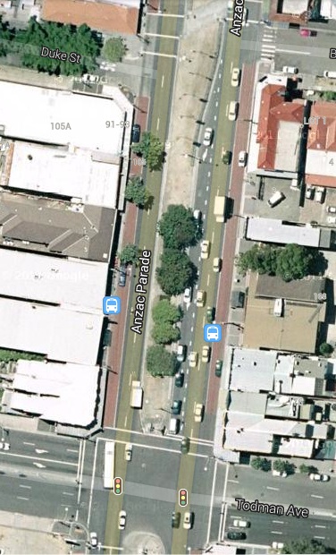
To reach destinations in Kensington from Eastern Australia from Kirribilli to Cape York you have a binary choice: you can turn left into Todman Avenue from South Dowling Street or right from Anzac Parade. I don't have off-street parking and there is a steep gradient so the bike is easy to knock over, so I arranged to leave it at a carport at a unit in Lenthal Street while I was in Broome. I missed the right-hand turn from Anzac Parade to Todman Avenue so I got to find out how far one has to go to turn around in Anzac Parade. I was able to make a right-hand turn into Day Street at an intersection without traffic lights just south of NIDA.
Day Street is the boundary between Kensington and Kingsford and is the only street distributing traffic to the whole of the Kingsford grid so this is an important right-hand turn. Without this turn all traffic to Kingsford from the north would have to turn into Todman Avenue and pass through Kensington. And the turn into Todman Avenue has enough to deal with. Satellites pass overhead at all different times so Google Earth choses times around noon, when there are less shadows, for their snapshots. The screen-shot above was not in the morning or afternoon peaks, but the right-turn lane, which stretches an entire block, was full of vehicles during the traffic-light phase in operation at the time of the snapshot.
In roads without tram lines right-hand turns take place simultaneously during the same phase or take place with only one direction blocked. However, hook turns where more than two or three vehicles typically turn right during a traffic-light phase, require separate right-turn phases for each direction, when nothing else moves.
So we can deduce that the right-hand turn at Day Street will be retained. Unfortunately hook turns at intersections without traffic lights are really scary. The driver must wait for a simultaneous gap in three lanes of traffic and two tram lines carrying, we are told, trams in each direction every two or three minutes. So the intersection will need traffic lights, and the hook turn will block both directions of traffic.
We can also deduce that the dot called University of NSW, NIDA will indeed be south of Day Street wedged between the buildings on each side of Anzac Parade. It will be a fair distance south to allow a left-hand turn lane into Day Street and will need its own pedestrian crossings.
We are in a position to assess the damage O'Farrell is inflicting on the public bus services along Anzac Parade:
- Two lanes of vehicular traffic forced into the one and only bus lane.
- At least one extra traffic lights controlled intersection.
- Traffic flow impeded by hook turn phases throughout the length of Anzac Parade.
- Extra pedestrian crossings at each tram stop.
No comments:
Post a Comment