Wednesday, 16 July 2014

The whole of Government


The Independent Review Traffic and Transport Assessment damning general comments were quoted in a previous post: "There appears to be significant work remaining to enable a full understanding and meaningful assessment of the Project's environmental impacts to be undertaken". The response of TfNSW was "implementation of the CSELR project will require whole of government collaboration". Samsa Consulting were not given any resources to independently assess the contradictory assertions in the EIS and PIR and their report was not released until the newly appointed minister for Planning and whatever else had signed off on the project.

In their response to the Independent Review TfNSW conceded that most government Departments would need to be subverted in order for the project to proceed but the key Department was the Department of Planning. The Minister Pru Goward confirmed that this Department had indeed been subverted when she approved the project as the Review was released.

An early start

Screen shot from Four Corners "Democracy for Sale"
The current inquiry at the ICAC has revealed that North Shore and Central Coast politicians were colluding to replace heads of Departments who might advise against plans to privatise public utilities before they were in office. The astonishing thing about the childish attempts of Liberal Party apparatchiks to force the resignation of the CEO of Sydney Water was the extent to which high-ranking members of the Party were involved. These activities were corrupt behaviour under the Act in the opinion of the former commissioner of ICAC David Ipp interviewed in the Four Corners program "Democracy for Sale".

This was confirmed by the findings of corruption against the former Mayor of Ryde, a career politician, who allegedly forced the resignation of a council official by releasing confidential information that porn had been found on a council laptop. This is not corrupt behaviour by a venal minor politician to gain financial advantages for family members, this is systemic undermining of the basis of the Westminster System of government.

Once they were in office there was no need to engage in corrupt practices to replace senior public servants. Public servants at the head of government departments could be replaced by amalgamating ministries and renaming public corporations. The one exception was the Treasury which has been a stand alone ministry under the Westminster system for centuries. Shortly after the election, O'Farrell forced the resignation of the Head of Treasury by making allegations which were subsequently shown to be untrue. Baird, the newly appointed Treasurer, got to appoint his own department heads. The newly appointed staff at Treasury went on the produce their first Budget with errors of more than $3 billion.

The Kingpin from Manly

Ze can't Count
The undisclosed plans of the North Shore rump to privatise the state's Water Distribution network that were in place before the 2011 election, have been exposed in the latest ICAC inquiry and have been abandoned following the resignation of O'Farrell, but the activities of Sydney Water Holdings was just a sideshow. The main game was always privatisation of the electricity distribution network. Insiders were staking out positions to take advantage,  before the election.

Roger Massy-Green gave $10,000 to Baird's election campaign from two separate companies at the same time, so he was aware that the donations were not legal. Baird did not declare any donations. Shortly after the election the Treasurer personally awarded him a $150,000 consulting contract at Treasury and he was appointed chairman of Networks NSW, the corporation that took over the poles and wires, for $200,000 a year. Not a bad return.

Privatising the poles and wires

That Baird should press ahead with the announcement that if he wins his first election he will consider he has a mandate to sell off half the city power distribution network demonstrates the contempt North Shore politicians have for the intelligence of people living south of the Harbour. After being in power for three years the government has not done any work to establish a justification for turning a public utility into a private monopoly. A Metro tunnel under the deepest part of Sydney Harbour has not been designed, has not been costed or shown to be physically possible, has not been subject to cost/benefit studies or feasibility studies and can be shown to be unnecessary. A road tunnel from Glebe island to the misconceived WestConnex road tunnel is a desperate attempt to cover up the obvious flaws referred to in a previous post, and has not been designed or costed. It will encourage motorists from the North Shore to overload the Glebe Island bridge which can not have its capacity increased.

The Baird government is the most incompetent government in the history of Australia and is flouncing from one disaster to the next.

Laughing all the way back to the jungle

Clover Moore boasted to the Press Club that the Sydney Council had done the work on the George Street tram alignment and had passed it off to the Liberal Party government. Her address was the usual relentless stringing together of mindless assertions with references to international experts. In the internet age you can find experts to tell you any thing you want to hear.

O'Farrell and Baird saw the tramway as a project to gratify their ambitions to be seen as infrastructure guys. There was never any attempt to establish the long term transport needs of the CBD.

Now O'Farrell will never receive a Premier's pension after a career where he has never been anything but a politician. Maybe there is a God of retributive justice after all.

The privatisation of the electricity distribution networks is the most radical policy taken to an election but there has been no disclosure of the projects it is supposed to pay for, apart from infantile computer-generated simulations of single-deck trains passing in separate tunnels in the bed rock under a stylised cross-section of the Harbour. It is hard to believe politics in NSW could have been reduced to this.

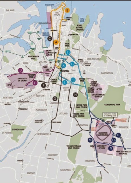
The tram alignment in the CBD is the key to establishing that a Metro tunnel under Sydney Harbour will never be necessary or financially viable so we will press ahead with however little information is available.

Wednesday, 2 July 2014

The sins of the North Shore are visited on the south

On any week day every vehicle in the northern CBD is there for a purpose. The number of off-road parking spaces is known and is controlled by planning regulations and is unlikely to increase markedly in the foreseeable future. The parking spots are also very expensive for regular commuting. There are large numbers of taxis kerb crawling for the remarkable number of taxi rank spaces - in European cities with old street layouts taxis wait off grid to be called on mobile phones. There are delivery vans and trucks carrying out business activities. North of Market Street the only through traffic in the CBD is headed for or from the North Shore and the volume of this traffic is unbounded. Only congestion will force this traffic to alternative routes. North Shore drivers are solely responsible for congestion in the Sydney CBD north of Market Street.

Congestion in bus routes in George Street north of Market Street was cited as the raison d'être for running trams along George Street - when the project was announced Sydney City Council had already produced broomstick-eye graphics of trams travelling along George Street. There was no information on what would happen to the bus services displaced from George Street, and unbelievably there still isn't, after TfNSW has produced an Environmental Impact Statement and a never-exhibited Preferred Infrastructure Report and Planning and Environment has published a Secretary's Assessment Report.

Chris Lock was more forthcoming at the Community Forum at Sydney High School in April 2013. He said commuters in the future would be forced to change between transport modes in making journeys through Sydney. In fact, it can be deduced that commuters will be forced to make four trips to get between Sydney University or the inner west and destinations along New South Head Road for instance. Currently it takes less than one minute for a bus to get from Railway Square to Rawson Place and another couple of minutes to reach Town Hall. Residents of the inner west are being forced to pay a heavy price for absolutely no gain and there is no rational excuse for this. Restoration of the Pitt/Castlereagh Streets tram loop makes Public Transport in the CBD future-proof and imposes no penalties on residents south of the Harbour.

Traffic in the arterial roads between the Eastern Suburbs and the rest of Sydney south of the Harbour is tangental to the CBD and has a marginal effect on the entry of buses to the CBD. Traffic flows in these arteries would be slightly affected by trams crossing Elizabeth Street at Hay and Campbell Streets. On the other hand, the North Shore rump government is deliberately creating grid lock at each end of Eddy Avenue in order to cripple public bus services and force commuters to transfer onto privately-operated trams.

"220 buses removed from the CBD"
The 13 December 2012 brochure claimed that about 220 buses would be "removed from the CBD" during the am peak. Chris Lock repeated this claim at the meetings in April 2013 before he became a recluse. 49 of these buses were removed from Chalmers Street and were clearly buses that terminated at the Lee Street layover. It turned out that the Metro buses (M10 and M50) would also be eliminated and these did not enter the CBD north of Park Street. 63 of the buses removed from the Victoria Road routes were sent on to God knows where in the Eastern Suburbs. Less that half the  buses "removed from the CBD" actually entered the northern CBD. They would be replaced by trams that would run on empty to Circular Quay after dumping passengers at Central in order to turn round.

The claim that "220 buses would be removed from the CBD" was reiterated in the EIS prompting an bemused response from the "Independent Review of Traffic & Transport Assessment" which was commented on in a previous post "Total subversion of the Public Service". However this claim had been contradicted comprehensively in the brochure Sydney City Centre Access Strategy published just before the end of the exhibition period. This stated that about 50% of the buses from Broadway would be terminated before Elizabeth Street (88 buses) a huge discrepancy from the 33 buses removed, God knows how, that were the basis of the claim. TfNSW refused all requests to reveal which services would be terminated and where they would physically turn round. Only a Royal Commission into TfNSW could unravel what was going through the minds of the public servants who made this claim. There will be a Royal Commission held either after the State election on 28 March 2015 or after pedestrians are killed and injured leaving and entering Central Station.

The never-exhibited Business Case for the CSELR
There is no reason why passengers on services that do not encounter congestion in bus routes in the northern CBD would leave the bus to transfer to a tram - the buses in Chalmers Street are not appreciably impacted by traffic travelling from southern Sydney to destinations in the Eastern Suburbs. To get passengers to transfer to trams the North Shore government must forcibly terminate the services God knows where or create gridlock at intersections used by buses to access the City. The Baird government will use both these stratagems if Baird is elected on 28 March 2015.

The business case for the Cross City Tunnel assumed that motorists could be forced to use the tunnel by congestion in a narrowed William Street. This only works in peak hours and the resentment aroused makes it more certain that motorist will not use the tunnel except in peak hours. The same rules would apply to transfers to from buses to trams.
The trams would not be viable from student-concession holders alone so bus services would have to be incapacitated for most of the day. The Preferred Infrastructure Report (PIR) released months after the exhibition period had closed shows how ruthlessly this is to be achieved. A two-way bicycle path obliterates the lane used by buses from Foveaux Street and from Chalmers Street to reach Eddy Avenue. Lycra-shirts riding in concert with trams broadside pedestrians waiting for trams to pass knocking them into the path of the trams. Mothers with prams and the disabled are particularly vulnerable.

Only the Sydney City and Randwick Councils were permitted to comment on the PIR but the indicative plan of Parsons Brinckerhoff were as always cropped to conceal what happens to the bicycleway in Eddy Avenue - presumably the bus stops are moved to the west of the pylons of the tram overpass so passengers alighting to transfer to Central Station are blindsided when crossing the tram tracks.

Bus services from Clovelly, northern Coogee and Bronte and from Botany are collateral damage in the North Shore push to cripple public bus services south of the Harbour and force passengers onto privately-operated trams. The bus services from South Sydney and Botany are particularly savaged. Buses that enter the bus bay south of Foveaux Street are trapped by traffic queued at the gridlocked intersection. When kerb blisters were built in Elizabeth Street at Martin Place bus drivers refused to be trapped at the pedestrian lights and stopped in the through lane second from the kerb, but congestion here affected only passengers boarding buses north of Martin Place and it was only a pedestrian crossing. Gridlock at the critical Foveaux/Elizabeth Streets intersection creates inestimable delays in the bus journeys of every commuter from the south of Sydney to every destination in the CBD.

Residents of Bronte, Clovelly and Coogee should note that their MP Notley-Smith was in on it right from the start but has said and done nothing to look after the interests of his constituents or even to keep them informed.

The Pitt/Castlereagh tram alignment does not create gridlock in any of the traffic arteries between the Eastern Suburbs and the rest of Sydney south of the Harbour and does not degrade any existing bus service.

Saturday, 28 June 2014

The above-surface Foveaux Street connection

Moore Park Bus Roadway exit
Buses exiting from the Moore Park bus roadway, which was originally a tramway, go one of three ways:

  1. Along Flinders Street to Oxford Street and Liverpool Street to turn into Elizabeth Street
  2. Onto the Eastern Distributor to Bent Street to turn into Elizabeth Street southbound
  3. Along Fitzroy Street and Foveaux Street to Elizabeth Street
The Foveaux Street route sets down passengers transferring to Central Station in Foveaux Street and continues north along Elizabeth Street. It is used for services that have insufficient catchment for separate services to Railway Square and Circular Quay to be viable, such as services to Clovelly. The 13 Dec 2012 brochure announced that the trams would remove 220 buses from the CBD in the morning peak and had figures showing bus volumes on approach roads before and after the advent of the trams. The buses along Foveaux Street were to be obliterated. These routes did not go within cooee of the tram terminals so it was impossible to to ascertain how this would be achieved. There is still no information on what fate the North Shore politicians have in store for the residents of Clovelly and northern Coogee. Their MP Notley-Smith was in on it but has no concern for his constituents.

There were never trams along Foveaux and Albion Streets - they were to steep. Trams to Randwick and along Anzac Parade went along Oxford and Flinders Streets. When buses replaced trams they followed the established tram routes which were marginally shorter than the Foveaux Street route, but not shorter in time during the AM peak because of overcrowding of the right turn from Liverpool Street into Elizabeth Street northbound. A tram service in parallel with the bus road (orange line) and using the Campbell Street connection would be so superior to the Flinders Street bus services - the trams avoid the Liverpool Street turn, the congestion at Market Street, the mother of all pinch points between the Old Supreme Court Building and the St James Centre and the congestion in Phillip Street. They would all but replace the Flinders Street bus services to the northern CBD. The trams and buses would switch lanes north of South Dowling Street.
Taylor Square Tram tracks
The inbound rails swing round the old Commonwealth Bank building, now garrishly painted. The remaining Flinders Street bus services could use the tram lane - there is ample space for buses to queue at the intersection to go round the corner to the stop in Oxford Street (there is no reason to allow taxis, bicyclists and motorcyclists to use this lane). With Flinders Street feeding fewer buses into the mother-of-all pinch point in Elizabeth Street more bus services would use the Foveaux Street route to Elizabeth Street. This has the advantages of relieving congestion in the Oxford Street bus route to Circular Quay at Liverpool Street and at the mother-of-all pinch point in Elizabeth Street southbound - the southbound route is along Castlereagh Street. Also, this route picks up passengers from Central Station on the northern side of Eddy Avenue reducing the need for bus services from the southeastern suburbs to the Lee Street layover (Railway Square).

The outbound tram alignment
The outbound tram rails (red line) go along Bourke Street to Albion Street with stops south of Campbell Street and north of Albion Street. Campbell Street is one-way east of Crown Street and Bourke Street is one way north of Albion Street.

Whichever route buses take to Elizabeth Street they all return to the southbound busway via a bus lane from Albion Street to Moore Park Road. The outbound trams would share this lane. The distance of the shared lane is less than the distance of shared lanes from The Strahan Street stop to the Kingsford terminus. The indicative plan of Parsons Brinckerhoff showed buses wafting into this lane at random intervals from one of the two narrow parallel general traffic lanes. I objected to this in posts on this blog and in my submission to the EIS. The dotted lines on another figure do not reveal right hand turns to Bunnerong Road will be from the shared lane and movements on this shared lane are complicated by a right turn into Gardeners Road for general traffic - vehicles that encroach onto the alignment will be run down by trams with priority signalling just like buses. "The Secretary" did not deign to comment on these matters in his Assessment.

In Flinders Street entry to the shared lane would be controlled at traffic lights and priority to buses and trams in the final section east of South Dowling Street over entry from left turning traffic would be implemented by the traffic lights at this intersection. Presumably the world famous SCATS system could coordinate the traffic lights at South Dowling Street and Moore Park Road.

The bus stop in Flinders Street between Albion and South Dowling Street would be moved to north of the pedestrian crossing on the northern side of Albion Street. There would be no tram stops between the southmost stop in Bourke Street and an ARL Central stop south of Moore Park Road.

The red line in the top figure shows the route of the outbound shared lane. Inbound trams and buses would cross Moore Park Road in parallel. Buses would separate to the right from the shared lane shortly after entering Moore Park and return to the southbound busway:
The return to the Moore Park busway
Inbound trams would cross this bus path after leaving the ARL Central stop in order to cross Moore Park Road in tandem with buses. The ARL Central stop would be located on a denuded strip of park used to access parking when events are held. No mature trees would be harmed in the alignment.
No mature trees are harmed in this tram alignment
It may not be necessary to move the historic sandstone gateposts depending on how accurately bus drivers can align their buses.
The entry to the busway
Doomed pedestrian/bicycle crossing
Pedestrian Crossings
Which brings up the question of what happens to the pedestrian and bicycle crossing of the bus way on the southern side of Moore Park Road? Its fate has already been sealed by the Baird Government. Permitted pedestrian and bicycle movements have been published. To get between the stadium precinct and Surry Hills you will have to use the snail-shell spirals of the overpass or cross Moore Park Road to the east of Flinders Street and cross Flinders Street on the northern side of Albion Street.

The busway is closed because of work on this overpass designed by TfNSW and overwhelmingly objected to, even by the North Shore Tea Party hatchet man Tony Shepherd. There are conditions that there will be no construction on the light rail project until some details of the CBD bus plan are released, that is to say until after the State Election on 28 March 2015.

The crossing at Moore Park Road would remain closed with the Flinders Street tram alignment. The only pedestrian crossing of the shared tram/bus lane would be the existing crossing on the western side of South Dowling Street. The EIS for the Eastern Distributor showed a bus stopped at Drivers Triangle. I pointed out that anyone who alighted here would have nowhere to go except to jump into the on-ramp to the the Distributor and it did not go ahead. So restricting pedestrians to this one crossing makes sense.

Thats it folks
This relatively short post has described the Flinders Street/Campbell Street tram track alignment in more detail than the George Street alignment has been described in an unbelievably voluminous Environmental Impact Statement (the public servants at Transport for NSW and their highly paid consultants have a cloying need to be acclaimed as geniuses), a never exhibited Preferred Infrastructure Report and an inane Secretary's Environmental Assessment Report (who the hell is this all powerful Secretary). The description has no deliberate contradictions; nothing has been cropped or withheld. The description is the same as outlined in a letter to the Minister more than a month before the Project was declared to be critical State Significant Infrastructure.

It ain't over until the fat turd* sinks
*Colloquially a Floatie
The Baird government will not begin construction on the Project until after the State Election on 28 March 2015. I have no idea if contracts can be signed before then, but contracts can be broken. Neville Wran cancelled contracts to build carriageways over Darling Harbour and went on to record Wranslide election results.
The people of NSW dodged the bullet in 1976 but now we are facing a cannon.

Baird has said that if his government is elected for the first time he will consider it a mandate to sell city power poles and wires supposedly to build at any cost projects that only benefit the North Shore and have not been designed, costed, subjected to a cost-benefit study or been subject to a feasibility study. The projects exist only as a line of dots on crudely drawn maps and the dots change with every press release. Here we go again. The age of entitlement for the North Shore is just beginning.

Projects will be declared to be critical State Significant Infrastructure to avoid any independent scrutiny.

The election on 28 March 2015 will decide the future of the City of Sydney

Wednesday, 25 June 2014

The Campbell Street connection

Buses from Parramatta Road and City Road have to travel north at least to Campbell Street in order to physically turn around. It does not make any sense then for trams to access the CBD south of here. Running coupled 90 metre long trams through the three major pedestrian crossings from Central Station and blindsiding pedestrians would not be acceptable anywhere in the civilised world. It is also completely unnecessary. If trams from the southeast enter the City to the north, the Randle Street loop that worked impeccably during the Olympics and at events ever since remains virgo intacta. The trams are an additional resource for clearing the crowds. It is Baird's obsession with crippling the Public Transport system and forcing people onto privately-operated transport that is the sole motivation for this disastrously misconceived tramway.
Connecting Campbell Street trams to the Pitt/ Castlereagh Street loop
I outlined how trams from the southeastern suburbs would connect to the Pitt/Castlereagh Streets tram loop in my letter to the Minister more than a month before Hazzard declared the undeveloped Project to be critical Significant State Infrastructure. The tram rails are side by side in the lower part of Campbell Street west of Hunt Street and occupy the redundant left-turn lane in Campbell Street and then some to the east of Hunt Street. Outbound buses would access Crown Street by travelling straight up Goulburn Street which is now one way all the way, east of College Street. The tram tracks in Campbell Street do not obey the drive on the right rules which is of no matter since the tracks are isolated from pedestrians for most of the route and would have an appropriate speed limit for this limited distance.

Inbound tram services
Campbell Street westbound west of Elizabeth Street is just a rat-run for vehicles that choose not to use Eddy Avenue or Hunt Street to reach Pitt Street or George Street. It would be closed to vehicular traffic other than trams east of Pitt Street and buses to the west.
Campbell into Castlereagh thence Central Station 

Campbell at Elizabeth Street
There would be separate tram services from the southeastern suburbs to Central and Railway Square and to the northern CBD, as has been the case from the foundation of European settlement in Sydney. The width of the roads in the northern CBD was predicated on this policy.

Because the rails do not obey the keep to the right rule there would be inbound stops at Taylor Square and say Harmony Park. There would be no right turn from Campbell Street into Elizabeth Street just a left turn. Vehicles including buses would use Hunt Street to make this turn - there are no destinations between Campbell and Goulburn Streets.

In a previous post "Managing congestion with the Oyster (aka Opal) Card" I outlined how the Opal Card can mitigate congestion in George Street bus lanes north of Market Street in the few hours of a week day when this is a problem. This is the case even if there are no tram tracks to the north of the CBD. With the Pitt/Castlereagh Streets tram loop restored there is a fourth terminus in the CBD for Parramatta Road and City Road bus services. Buses can terminate at Campbell Street, making a left turn from Pitt Street. Passengers can transfer to Loop, southeastern Suburbs and Lilyfield Line trams by crossing Campbell Street to a stop in Pitt Street. Buses terminating here cross the Lilyfield rails coming and going but they do not cross tram tracks a mind-numbing five times while running on empty after dumping their passengers in Pitt Street, as proposed by TfNSW. This terminus does not offer opportunities for buses to lay over and would mainly be used during the AM peak. The cost on the Opal Card would be the same as for a service to Randle Street. With the Opal Card commuters can change to a service to the appropriate destination at any stop in Parramatta Road or King Street as pointed out in the previous post.

Most tram services from the Lilyfield Line would continue to the north of the CBD but there would be the usual choice of destinations to Central Station. Off-peak services would stop at Central on the way north.

The Loop tram services add additional capacity to transport services to the CBD and do not degrade any existing bus service. They make Sydney CBD transport future-proof.

Outbound tram services
The outbound tram rails are through the "Golf House" building and the building behind it as outlined in my letter to the Minister and submission to the EIS. There would be a stop here then the next stop would be at Bourke Street. The trams would enter Foster Street at a higher level and Foster Street would be closed to traffic between here and Campbell Street. The air rights above this stop could be flogged off at a later date.
The Golf House
Foster Street at rear of Golf House
Blackburn Street - closed at end
The trams services to the southeastern suburbs would be on a demand basis and would be additional to existing bus services to Elizabeth Street and Central and Railway Square which are largely unaffected. Bus services to Railway Square to not contribute to congestion in bus routes to the northern CBD which was falsely advanced as the raison d'être for tram rails in George Street.

The tram services from the southeastern suburbs to the northern CBD would actually be faster than existing Elizabeth Street bus services even without priority signalling, being a more direct route with less queuing at intersections. Tram movements would be in parallel with bus movements and vehicular movements and controlled by the SCATS system.

The plot thickens
The northern lanes of Campbell Street are currently being butchered for a one-way bicycle path. So there is a binary choice: you can have an efficient and safe tram service to the CBD from the southeastern suburbs or yet another plot for cultivating inner-city pansies.

The main reason for the Pitt/Castlereagh Street tram Loop is to reduce localised congestion on the City Circle trains, something the George Street tram alignment conspicuously fails to achieve - it does absolutely nothing to reduce this congestion. It has been demonstrated that a competently designed tram system for the southeastern suburbs can compete successfully with bus services without crippling them with deliberately generated congestion in crucial traffic arteries or forced termination of services.

I will discuss the Flinders Street end in another post.

Tuesday, 24 June 2014

Surry Hills routed

The Minister for Transport told a packed community meeting in April 2013: "No matter which route we chose it would cause disruption to people who lived in that street. Its true." You can see her saying this in the video in the bottom panel. This was deceptive. There are routes that do not create a killing field for pedestrians, do not grid-lock the arterial roads between the Eastern Suburbs and the rest of Sydney south of the Harbour and do not degrade every bus service to the CBD. The meeting asked for a professional Feasibility Study which has never taken place.

I wrote to the Minister the next day outlining a route that had none of the obvious flaws of her project. You can read my letter here. Nothing has changed with the route I described. I will outline it in more detail in this blog which has the advantage of pictures than expand to full size when you click on them.

Hazzard warning

O'Farrell on election day
O'Farrell appointed the Manly-educated Brad Hazzard as Minister of Planning and Infrastructure upon his election on March 28 2011. Brad Hazzard you may recall had admitted that his testimony to  the Independant Commission against Corruption was false along with Greiner but had not suffered any sanction. Within a few months he made amendments to the Environmental Planning and Assessment Act 1979 which took force on October 1st.

The amendments provided for projects to be declared State Significant Development, State Significant Infrastructure or Critical State Significant Infrastructure. Projects so declared would be approved by the Planning Minister without anyone having any right for judicial review by the Land and Environment Court - not even democratically-elected Councils. Randwick Council objected to the tram terminus in High Cross Park in their submission to the EIS and maintained their objection in their response to Preferred Infrastructure Report which finally revealed that the arterial road into Coogee would be reduced to one lane. They had no say in the matter.

Baird has appointed Hazzard Attorney General and he has called on the Director of Public Prosecutions to launch actions against witnesses who gave false testimony to the ICAC. There must be a statute of limitations.

Critical State Significant Infrastructure

Deputy Director General TfNSW Chris Lock
A few days after his disastrous appearance at the community forum at Sydney High School Chris Lock received a rapturous reception at a Randwick Businessmen's breakfast. If they had served Kool-aid it would have been lapped up. Only now are the burghers of Randwick realising what they are being forced to sign up for. Following the breakfast Chris Lock would become a recluse and the Minister for Transport would refuse to answer any questions in Parliament on the light rail project.

At the community forum the Minister said you can criticise me but do not attack the Public Servants. The Minister would put herself beyond criticism. On 20 May 2013 Hazzard declared the CSELR proposal to be State Significant Infrastructure and critical State Significant Infrastructure. The letters received a month earlier from me and others pointing out the obvious flaws in the project which was just a line of dots on a crudely drawn map (shown in the header to this blog) would be ignored; the Public Servants and their consultants would be free to write a deceptive EIS containing contradictory descriptions. The Minister was answerable to no-one.

Only a change of government on 28 March 2015 can save the City of Sydney from catastrophe.

Monday, 23 June 2014

Like father, unlike son

👍father   👎son
Bruce Baird was Minister for Transport in the Greiner government from 1988 to 1995. He was a self proclaimed member of the God Squad in the parliament. Public transport particularly trains had been allowed to deteriorate during the Askin era and Baird wanted to reassure the electorate after the Party had suffered landslides against it. Unfortunately he was not very intelligent.

He put up schemes that were ridiculed in Parliament. He wanted to close down Museum Station and establish a station under the Goulburn Street car park. It was pointed out the there was no room for platforms in the narrow site. Another brainwave was to close the Country Steam station built in the first years of the 20th Century to country trains. These services would be relocated somewhere else. Fortunately he had Public Servants to advise him on his follies.
Central Station
Central Electric had been built alongside the Country Rail terminus when the underground rail loop was built over an 8 year period up to the opening of the Harbour Bridge. The plan was to make more platforms available for suburban train services. This plan was also howled down. There are in fact a large number of greater suburban train services that terminate at central as can be seen in the aerial shot. Commuters terminated here flood down the escalators to the City Circle and Harbour Bridge platforms and cram onto the City Circle trains. This is not what was planned when the Central Rail terminus was built in the first years of the 20th Century.

The tram colonnade was an integral part of the design of the terminus and the tram loop distributed train passengers to the rest of the CBD and to the ferry wharves at Circular Quay which gave access to the rest of Eastern Australia north of Kirribilli.

Tram tracks of 20th Century Sydney
The tram loop up Castlereagh Street and south along Pitt Street was the last of the tracks to be laid in the CBD and Central Station was as much a source of civic pride at the start of the 20th Century as the Opera House is today. Not all trams went all the way to Circular Quay; some looped back to Pitt Street at Bent Street. Before the Harbour Bridge was built most trams would have gone to Circular Quay but even the wildly-optimistic figures for passengers transferring to trams at the designated stops generated by TfNSW for the EIS concede that hardly any passengers will transfer from ferries to trams. A tram stop in Spring Street is as far north as the tram stop in in George Street between Bond and Bridge Street and just a stone throw from the bus set-down stop in Bridge Street for George Street bus services terminating at Circular Quay.

Spring Street into Bent Street
There are a plethora of train and bus services that pick up passengers at the ferry wharves. In this day and age there is no valid reason for a tram service to have a terminus at Circular Quay although it is possible for some trams to loop from Pitt Street to Young Street or Loftus Street. The tram track alignment along Pitt and Castlereagh Street does not degrade any existing bus service into the Sydney CBD.

Locating a three-platform tram terminus for 45 metre long trams that are carrying negligible numbers of passengers in the heart of one of the most internationally famous tourist precincts in the world is so mindlessly destructive that it brings the sanity of the Public Servants and North Shore politicians responsible into dispute.


Alfred Street is another pedestrianised zone where pedestrians are blindsided as at the exits from Central Station. This was as usual concealed by cropping in the EIS - another killing field in a tourist mecca. Tourists will not have encountered anything as callous towards human life anywhere in the world. The revised EIS (Preferred Infrastructure Report) did not change a thing about this terminus or the Rawson Place stop and only the Sydney City and Randwick Councils were allowed to make a submission.


I have published posts on this stop on this blog as information became available (see Lies, deception and subversion of Public Servants at Circular Quay 28/12/2013) which will remain archived on Google servers. They are freely available to contingency law firms.

Change of plans

The exhibited EIS published figures of projected passenger transfers at tram stops and projected loadings of trams between stops in an attempt to show the trams would have sufficient capacity at least up to 2021 - i.e. the loadings would be beneath the infantile claim that the trams could carry up to 9,000 passengers per hour. The Preferred Infrastructure Report (PIR) admitted that figures were erroneous and had new figures. Both figures confirmed that, even with the ludicrously optimistic assumptions of TfNSW, the peak number of passengers on the trams at Circular Quay, even with the obliteration of the George Street bus services, is negligible.

The revised figures for intermodal boardings at stops do not reveal whether they are for outbound services only or both directions but the PIR insists the figures in the Central Station Precinct Access Plan were correct:
Table 7-11: Central Station Precinct Access Plan
The 2387 passengers transferring from the trains is less than the 2669 passengers that are projected to get on the outbound service in Chalmers Street in the AM peak. That is to say, TfNSW projects that a negligible number of the rail passengers terminated at Central Station will walk past the City Circle platforms where they can continue their journeys to destinations in the CBD for nothing extra and instead leave the station to catch a tram a long way down Chalmers Street that accesses only three of the destinations of City Rail and shuts down for an indefinite period every time a bus passenger is slaughtered or injured. This is an unexpected acknowledgement of reality. The George Street trams will do nothing to alleviate localised congestion in the City Circle and Harbour Bridge trains!

On the other hand, restoration of the Pitt/Castlereagh Streets tram route provides a short walk across the Central Station concourse, under cover and with complete safety, to catch a tram with as many stops as a bus route in the CBD. The trams provide additional capacity for Public Transport to the northern CBD and do not degrade any existing bus service.

I will reiterate in more detail in this blog how a tram service to the South Eastern Suburbs would be integrated with this tram route. I outlined all this in my letter to the Minister for Transport in April 2013 and in my submission to the EIS. The Secretary's Assessment did not acknowledge that such a route exists.

Wednesday, 18 June 2014

The Do something-else scenario

The Final Secretary's Environmental Assessment Report reported that "more than a quarter of all public submissions received (26%) raised issues about the preferred route, indicating a preference for different route options".
Route options assessed
Planning and Infrastructure dutifully assessed the ludicrous route options considered at Round Tables of stakeholders and shown in the figure (left) reprinted from the EIS. The blue route options were presented to Community Forum at Sydney High School in April 2013 and were howled down at the packed meeting. I could not sleep after the meeting and the next day wrote to the Minister outlining a route option that had never been considered by the Knutters of the Round Table and had none of the obvious flaws of the chosen option. You can read my letter to the Minister here. I had no idea at this stage that the bus terminus at Randle Street would be obliterated along with all the bus terminuses accessed by George Street.

The Minister's response was to declare the proposal to be State Significant Infrastructure and critical State Significant Infrastructure on 20th May 2013. Under this amendment to the Environmental Planning and Assessment Act 1979 brought in by the O'Farrell government in 2011 there can be no appeals to the Land and Environment Court against an Assessment. Public Servants are licensed to do as they like.

I described the route option in more detail in my Submission to the EIS. This has been in the public domain on the majorprojects.planning.nsw.gov.au website along with all the other submissions but I do not know for how much longer. I have provided a link from this blog here

My Submission was closely worded and stretched to 11 pages and I was only getting started but I was wasting my time. None of the matters raised by me and all the other people that made submissions about the route were assessed by the Department. The Consideration in the Assessment Report dismisses all objections and comments in the submissions with a single paragraph. "Overall, the Department considers that that Applicant has undertaken an appropriate and comprehensive route selection and evaluation process to identify the preferred alignment. The department notes that investigations were undertaken to identify possible route alignments at both a macro and micro level, with appropriate criteria and objectives guiding the process. The Department is satisfied that the Applicant's selection process has been rigorous, and that the optimal alignment has been identified".

Are we not stakeholders?

On 28th March 2015 we the people are the stakeholders. We have the opportunity to put a stake through the heart of an infantile reincarnation of the Askin Government from the North Shore rump of the Liberal Party. The Baird government are the most incompetent, callous and self-centred politicians to emerge from the North Shore rump, ever. They came to power through a corruptly funded election process and act as though they are answerable to no one. If Beard is not sent packing back up the North Shore rump on March 28th the City of Sydney that we have built up over 200 years will be made unworkable and the States assets will have been squandered of ludicrously expensive infrastructure projects that create more problems and do not address the needs of the city. To this end I will outline on this blog how the light rail alignment I described in my letter to the Minister and in my Submission resolves most of the transport problems faced by the City of Sydney.

Do-min


The EIS contained figures and tables purportedly showing the deterioration in the Level of Service of intersections if the tram system was built compared to a Do-min case if the tram rails were not built. The deterioration of the Levels of Service at the crucial intersections at both ends of Druitt Street when the revised figures given in the Preferred Infrastructure Report are included will cause a devastating degradation in the performance of every bus service that enters the CBD from south of the Harbour including the Eastern Suburbs, especially where there is little opportunity for bus layovers. Hilariously TfNSW assert that the figures for traffic flow will be 7% higher if the trams are not built and only 6% higher if they are built because people leave cars at home and use buses. This preposterous assertion formed the basis of the Business Case.

In my submission to the EIS I pointed out that "there is a ridiculously simple way of testing these assertions. TfNSW has number plate recognition. If they lack the competence to do this work their consultants Sky High would be able to do it. By mounting in George Street ,say at Martin Place, and a camera in Anzac Parade they could count the number of cars that enter all day car parks in northern George Street from the 'catchment area'. This is the maximum number of commuters who could possibly decide to leave their Maybach convertible in the garage and catch a bus then a tram." I asked the assessors to do this work - to no avail. So the disparity between the projected traffic flow figures in 2021 for the Do-min and With-trams cases will be substantially in the other direction. The deterioration of traffic flow in the historically sine qua non main traffic arteries between the Eastern Suburbs and the rest of Sydney south of the Harbour will be far greater and the degradation of all the bus services from these areas to the CBD will be far greater than the figures from TfNSW predict. There is a vicious circle and the situation will get progressively worse for the rest of the life of the City.

Do something else

Doing nothing to improve the movement of buses in the CBD was never an option. A competent feasibility study would have compared the George Street tram alignment with the other options. These would have included the options outlined in my letter to the Minister and my submission to the EIS - using the Opal card to limit congestion in the northern half of the CBD during the few hours of week days when there are problems with scheduling can be implemented immediately and adds very little to the cost of rolling out the cards.

Brown peril
If it is necessary for buses from Parramatta Road and City Road to travel north to Hay Street in order to physically turn around there is no rational reason for trams to enter the CBD to the south of here, other than to blindside pedestrians using every crossing to and from Central station. There is no rational reason to create a killing field from Crown Street to George Street. There is no rational reason for forcing tram passengers into a pincer movement in order to transfer to a bus service along Parramatta Road or City Road.

The tram alignment outlined in my letter and my submission to the EIS:

  • Does none of the above.
  • Provides additional capacity to Public Transport in inner Sydney not the reverse.
  • Does not substantially degrade any existing bus service to the CBD.
  • Does not degrade traffic flow in the arterial roads connecting the Eastern Suburbs with the rest of Sydney south of the Harbour.
  • Makes a ludicrously expensive and yet to be shown to be financially viable Metro tunnel under Sydney Harbour unnecessary.
  • Can probably be extended to Sydney University.
  • Can be extended to the development at Barangaroo.
  • Mitigates the problems for North Shore bus services in York Street.
  • Relieves congestion in bus routes in Elizabeth Street northbound rather than make it intractable.
We the people of New South Wales can achieve all this if we
Send Baird packing on March 28