Showing posts with label Anzac Parade. Show all posts

Saturday, 3 May 2014

Who are they?

The Eastern Distributor under Darlinghurst is a tunnel wide enough to to carry three lanes of traffic on two levels. Where it is joined by the off ramp tunnel to William Street it is the widest tunnel in the world. The tunnels were drilled from north of William Street and from Moore  Park  meeting under Taylor Square. Suspending the upper three lanes on precast planks from the walls of the tunnel was a feat of engineering.

I was gobsmacked when Clover Moore rattled out her achievements at the end of the community forum on the light rail in April (she had the only microphone): "They did not want to grade-separate the carriage ways along South Dowling Street". It would have been an extraordinary feat of engineering the bring the lower southbound level up to grade. In my letter to the minister calling for the Harbour Tunnel and the Cahill Espressway to jointly provide the traffic needed  to make the moribund Eastern Distributor project economically viable I had pointed out that there would be a grade-separated highway from Chatswood to Botany Bay and eventually beyond - the grade separation of the carriageway along South Dowling Street was always an essential  part of the business plan.

The EIS for the Distributor, archived in the Fisher Library, lays out what was actually planned and was abetted by "concerned citizens" forums dominated by Moore. The exclusive bus road through Moore Park was to be shut down, and Riley Street and Reservoir Street were to be closed off to force drivers to use the motorway. The objections I and others raised were upheld be the assessors and the Distributor went ahead without controversy. That is to say the assessors accepted that changes to bus routes and road closures were matters that had to be disclosed and made a part of the Assessment process. The revised CSELR EIS, aka Preferred Infrastructure Report, demands that these matters, that were outlined in the EIS, be disregarded and be left for TfNSW to determine before the Project goes into operation.

One of the section figures in the EIS for the Eastern Distributor showed a bus stopped at Drivers Triangle. I pointed out that a passenger who alighted here would have nowhere to go but to jump into the entrance to the tunnel. This would have been regarded as an error in good faith and would not have been grounds for challenging the EIS if it had been a matter of community concern. The newly sworn in Baird government is dominated by politicians of faith, but they are clearly not of good faith.

Viaducts over Anzac Parade

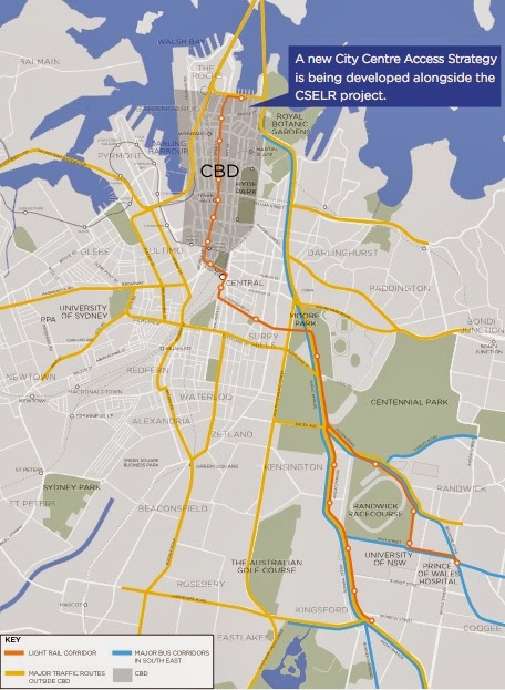
The exhibited EIS contained an entire chapter of 34 pages detailing how the self-proclaimed geniuses at TfNSW had grappled with "the design for the preferred CSELR route". Chapter 4.3.1 dealt with the "vertical alignment through Moore Park". The "two main options considered" were the tunnel under Anzac Parade announced in the December 13 2012 brochure and a viaduct over South Dowling Street, Moore Park west and Anzac Parade.

The EIS conceded that a viaduct would have safety benefits and would "avoid traffic impacts to local roads and South Dowling Street". It would also have lower cost. The EIS failed to realise that elevated platforms would also provide much greater access to crowds arriving and leaving events at Moore Park venues. The section concludes: "Whilst the viaduct is a lower-cost option, avoids an additional signalised intersection at South Dowling Street and would result in a marginal journey time benefit, this is not, on balance, considered to be sufficient to counter the potential visual impact and severance of the Moore Park playing fields".

The then Premier announced on 26 February 2014 that a pedestrian/cyclist bridge would be built over Anzac Parade. This bridge will be as wide as a tram viaduct, will have a greater impact on the Moore Park public spaces with its spiral access ramps and does not provide connections with existing cycle or pedestrian paths. The Premier's announcement stated that consultation has been carried out with stakeholders including event operators, local trusts, businesses, City of Sydney, Veterans Affairs and Transport for NSW. Clover Moore has denounced the plan following his admission of lying to the ICAC so the honesty of this assertion is also in question.

An alternative motivation for the announcement became obvious a couple of weeks later when TfNSW released the Preferred Infrastructure Report revising the preferred route in the exhibited EIS.

The signalised pedestrian crossing adjacent to Sydney Girls High School was to be closed down and a pedestrian bridge built across Anzac Parade with a zig-zag access ramp on land excised from the school grounds. Cyclists have an aversion to zig-zag ramps. So there will be two bridges, neither linked to existing cycle or pedestrian paths, within a stone's throw of one another.

The exhibited EIS stated: "at the EIS preparation phase exhibition for the CSELR undertaken in September 2013 the cut-and-cover tunnel was generally the preferred option of the community... Based on this options assessment, the cut-and-cover tunnel was retained as the preferred alignment". The "exhibition" consisted of handing out a postcard sized questionnaire with boxes to be ticked. Only extremely naive respondents would have returned the cards - not a scientific pole. If the people who responded to the questionnaire had been informed that the alternative to a tram viaduct would be two closely spaced overpasses they would probably have ticked another box.

Since the EIS cites this survey as the only reason for retaining the tunnel option, the survey must needs be repeated when the community has been fully informed before the Assessors can be asked to approve the Project.

A week is a long time in politics

17 April 2014
Over the Easter weekend newspapers carried advertisements by the Department of Planning and Infrastructure seeking to recruit Assessors. The ads cited the number of coal mining projects that would need to be assessed as one of the reasons for the recruitment drive and listed the wide range of qualifications that applicants should possess. The ads concluded that the function of assessors was to give professional, impartial advise to the Minister.

But which Minister? A week after being sworn in as Premier, Baird announced that he would be Minister for Infrastructure and Pru Goward was made Minister for Planning. Brad Hazzard, who had admitted along with Nick Greiner that their statements to the ICAC inquiry into the Metherell affair were wrong, is the new Attorney General - his old department is no more. The recruitment drive has disappeared from the face of the earth.

Nick Greiner had proclaimed O'Farrell to be an infrastructure Premier and Baird has said that infrastructure projects are the key to winning the next election for the coalition, but this is the first time that infrastructure has been separated from planning and the environment.

A week after the latest cabinet was sworn in by the State Governor two of the appointments have resigned after being named in the latest ICAC inquiry. The latest was the Police Minister who was also the government leader in the upper house.

Since the revised CSELR EIS depends on the Liberal Party government still being in power to implement closures of bus routes in the CBD years after the State election on 28 March 2015, the Assessors are faced with a moral and professional dilemma: do they approve an EIS that failed to disclose where terminated buses would physically turn around and rescinded whatever information on bus routes that had been published in the exhibited EIS and hope that the problems can be resolved?

The Manly boys

There was no information on where Baird lived before he became Premier - this was restricted. It turns out his house is in neighbouring Fairlight. Bob Askin lived in Manly all his life but had electorates on the Northern Beaches. Brad Hazzard grew up and went to school in Manly.

Dr Peter Macdonald was the independent MP for Manly and one of the four independent MPs who threatened to vote for a no confidence motion and forced Nick Greiner to resign as Premier. Brad Hazzard was not asked to resign as he was just a back-bencher when he admitted to giving false testimony to the ICAC.

Baird has made himself Infrastructure Minister but the plan to run trams along George Street is seen as a whim of the former Premier O'Farrell. Will Cabinet press ahead with the Project and face spending another 45 years in opposition?

Only the foolish would try to predict what will happen next in New South Wales politics.

Friday, 4 April 2014

One lane is insane

Infrastructure NSW recommendations
The O'Farrell government set up Infrastructure NSW headed by chairman Nick Greiner shortly after gaining office to give independent advice on projects. The advice it received was to build light rail from Central Station to Maroubra Junction, presumably, from the figures they released, subsurface under Foveaux Street since they would have known that Foveaux Street is too steep to take trams. They also examined the idea of running trams along George Street and issued a scathing dismissal of the prospect - some of their milder comments are in the sidebar.

Greiner and his Public Service colleague Paul Broad resigned in May 2013 when it had become clear that loonies had taken control of the asylum.

Loonies take control of the asylum

Revised plan of stop at UNSW
The stop at University of NSW is another stop that has been changed so radically TfNSW has published a whole new set of revised (cropped) indicative plans. The submission of the Randwick Council asked for modelling of the congestion that would occur in Barker Street to the west of Anzac Parade as a result of the tram rails closing the right-hand turn into Day Street. My submission also objected strongly to the closure of right-hand turns at Day Street. TfNSW has not undertaken the requested traffic modelling but asserts in Item 10.1: "Since the release of the EIS, further analysis has been undertaken of the right-turn movements and the space for right-turn bays in some locations is likely to need to be adjusted.
"A design change to the UNSW Anzac Parade stop is proposed comprising relocation of the stop to the centre of Anzac Parade."

The right-turn lane is very short allowing only three or four vehicles or one bus to queue to make a right-turn before the one the only general traffic through lane is blocked. Bus services to Kingsford currently make right-turns here but they will still be rerouted along rat-runs. The revised indicative plan refers to a "potential right hand turn (subject to discussion with RMS)". Roads and Maritime Services is to be Bad Cop who rejects the turn after the Assessors have approved the project, with nothing having been disclosed before the exhibition period closed.

No Hook Turns

The indicative plans of Parsons Brinckerhoff in the EIS were all cropped or arrows on lanes omitted to deliberately conceal whether Hook right-turn lanes would be used to cross the tram rails. There are very good reasons why hook turn lanes are used throughout Melbourne and with tram systems around the civilised world. One of the most important is that it is impossible to stop vehicles waiting to turn right from "encroaching onto the light rail alignment". When a tram with priority signalling inevitably hits such a vehicle the airbags deploy and the vehicle is spun into the path of through traffic travelling in parallel with the tram. When the vehicle is hit in on the other side the airbags are deflating to avoid smothering the occupants - the end of the whole family.


Emasculating Environmental Protection

Section 5.8.1 of the submissions report summarises the large number of "concerns about lack of certainty about changes to bus network" raised in responses to the EIS, and this is fair enough. The response of TfNSW is: "The NSW Government released the final Sydney City Centre Access Strategy (SCCAS) and Sydney's Bus Future in December 2013. These strategies form the basis of the Sydney City Centre bus network and changes to the South East bus network."
Figure 4.2 from EIS (re-post)
The EIS published tables and the figure reproduced again (left) led to the concerns in many of the submissions to the EIS. I raised several objections in my submission, based on the data in the EIS.

Now the only response of TfNSW to all these objections and concerns raised in submissions to the EIS is to ask the Assessors to ignore the data in the EIS and the concerns that arose and to give approval to the project on the basis of brochures that were not included in the EIS and were not released to the public until after the EIS went on exhibition. I do not know when the SCCAS brochure was released in December but the second brochure was released two working days before the exhibition period was due to end.

If this is legal then the EIS legislation has been drained of its life blood and is all but worthless.

The response goes on: "TfNSW will commence detailed planning for the South East bus network in 2016/2017 in preparation for the commencement of CSELR operations". That is, one year after the next state election. The state government has not established that there is any pressing need for O'Farrell's whimsical project - quite the contrary. In my submission I asked the Assessors to not give approval to the EIS until TfNSW has established where bus routes can physically turn around.

TfNSW clearly believes that the Assessors are imbeciles, or it has inside information that the Public Servants at Infrastructure and Planning have been subverted along with those at the monster bureaucracies set up by O'Farrell, RMS and TfNSW.

So where do buses turn around

The trams along George Street obliterate all the places in the CBD where buses can physically turn around except for Phillip Street, but this post deals with Anzac Parade. The concern is listed in Volume 1 Part A Section 5.8.1 as
  • Further information requested about where buses will turn around at Todman Avenue following introduction of the CSELR proposal.
Bus services that will be forcibly terminated at the Kingsford tram terminal transfer passengers to privately-operated cattle cars but the tram rails make it physically impossible for them to turn around. Buses must travel on empty until it is physically possible to turn around. This is not until the buses have passed through the newly created "pinch points" at the Strachan Street stop and the revised UNSW stop above. We can deduce: not until Todman Avenue. The University of NSW is the nigger in the wood pile for Anzac Parade having built the sheer glass facade of the foyer of the NIDA theatre on the plot boundary opposite the "Square House". Pavement widths and lane widths must be reduced on either side of the stop.

Once a bus reaches Todman avenue there are extra lanes and alternative routes along Todman Avenue and Doncaster Street, but this is where O'Farrell will terminate bus services to force passengers to transfer from public buses to privately-operated cattle cars. TfNSW has refused to disclose how buses will physically turn around at this terminus prompting the submissions pleading for more information; but one can deduce that buses will be forced to turn right into Todman Avenue and return to Anzac Parade along Doncaster Avenue - the triangle of roads that TfNSW regards as a bus terminus.

Melbourne bus driver console
Drivers in NSW are expected to move forward to the centre of the intersection in preparation to efficiently make a right-hand turn - I failed a driving test for being ultra cautious and not moving forward. Parsons Brinckerhoff have as usual omitted the arrows on the lanes but the number of dashes between the lanes reveal that the right-turn lanes at Todman Avenue are not hook turn lanes. It will be physically impossible for drivers turning right to not "encroach on the light rail alignment". When they see a cattle car bearing down on them, with priority signalling, in their rear-view mirror they will have nowhere to go, trapped by vehicles behind them that have moved forward with them. Bus drivers of every bus service forcibly terminated at the Kingsford terminus, in particular, will be sitting ducks. Their only hope for survival will be to clamber over the Opal Card reader in time.
Todman Avenue intersection
The pupils at Kensington Primary School (cropped by Parsons Brincherhoff) have for generations been protected from heavy traffic since there is no right turn from Anzac Parade northbound into Todman Avenue. They will be experiencing trauma at regular occurrences since this murderous right-hand turn is the only access to Alison Street from Anzac Parade. Indeed, when buses reach their terminus at Todman Avenue the only passengers still on board will be students and staff of the school and parents escorting their children to and from school. O'Farrell really has it in for primary school children.

One lane is insane

Every bus terminated at Kingsford terminal has to travel to Todman Avenue to physically turn around. As pointed out in numerous posts the number of buses "removed" from the critical portion of Anzac Parade from Nine Ways to Todman Avenue is zero. TfNSW has promoted the trams as necessary to relieve congestion in bus lanes in Anzac Parade but the trams will undeniably make congestion a lot worse. With the public servants at TfNSW we are not dealing with rational human beings.

Newly completed Tyree building
TfNSW is proposing to build bus bays into the car park alongside NIDA and under the cantilevered wings of the newly completed Tyree building - no one would accuse the University of NSW of thinking ahead. When Frank Sartor was Lord Mayor Sydney City Council installed kerb blisters in Elizabeth Street at Martin Place, causing massive disruption over a long period. This turned the bus stop lane into a bus bay. Bus drivers would stop in the next lane out from the kerb to avoid being trapped indefinitely by traffic queuing at the traffic lights at the pedestrian crossing. Eventually this lane was made a bus priority lane and buses now use the bus stop lane, but general traffic is forced into one lane.

Elizabeth Street at Martin Place is a wider section between the "pinch points" at the Old Supreme Court Building and Phillip Street, and leads only to the dead end of Circular Quay, so this is not all that significant. Anzac Parade, on the other hand, is the only arterial road between the south eastern suburbs and Eastern Australia from Kirribilli and Cape York and TfNSW is reducing it to one lane for general traffic in the same manner as Elizabeth Street, creating "pinch points" at the UNSW and at the Strachan Street stop. This effectively reduces traffic flow in Anzac Parade to one lane for the critical section from Nine Ways to Todman Avenue. The mid-block crossings in the revised indicative plan have a lot more potential than a right turn into Day Avenue.

Residents of the south eastern suburbs will be paying a high price for the shortsightedness of the University of NSW, unless their only goal in life is to travel to Circular Quay.

The inherent problems in Anzac Parade at the University of NSW are exacerbated and basically originate in the design of the Kingsford terminus and the associated redesign of the Nine Ways intersection. There is no fundamental reason why a tramway cannot be built from Maroubra Junction to Central Station, as suggested by Infrastructure NSW, and to Circular Quay, as outlined in my submission. But first, we the people will have to elect a competent and socially conscious state government.

Thursday, 5 December 2013

Day is done

I presumed before the release of the EIS that there was too little wriggle room between the sheer glass facade of the foyer of the NIDA theatre and the University of NSW building to provide for a hook-turn lane into Day Street and maintain two lanes of traffic around the tram stop. It turned out I was right.
I did not believe that anyone in their right mind would eliminate the turn into Day Street from Anzac Parade. Day Street is the sine qua non route for the Kingsford bus services which go along Eastern Avenue, and are also the mainstay of the bus services along Crown Street and Campbell Street in Surry Hills. The main parking area of NIDA is also accessible from Day Street.

 I probably got that right too; but none the less TfNSW will be eliminating the right turn into Day Street. Booz & Company proclaim it bluntly in Technical paper 1 5.4.4. Functional changes:

  • The right turn from Anzac Parade into Day Avenue will be banned. This will require rerouting of bus services that currently make this manoeuvre. Pending further Council approval and investigation of impact to bike lanes this route will likely to be via Doncaster Avenue.
That is to say the buses will crisscross the rails northbound as well as southbound.
21 CSELR EIS Technical Paper 1 5.4.4.
There will be no right-hand turns allowed from Day Street into Anzac Parade so the parking area shown in the Figure left will be accessible only from rat-runs through Kensington and Kingsford. The Day Street intersection has been cropped in this Figure.

In fact Kingsford is to be ghettoized; with the only access from the north to the entire Kingsford grid north of Gardeners Road being a single hook turn lane at Barker Street. The main retail strip will not only lose all bus stops except for a stop so far north of Strachen Street it has been cropped from the data in the EIS, it will lose curbside parking and customers will need navsat to reach off-street parking areas.

The ghettoization is not as overwhelming as the ghettoization of Surry Hills as there are tortuous rat-runs through Kensington, but I would not like to be in the position of someone who has superannuation invested in their business in Kingsford.

Wednesday, 4 December 2013

Terminator 4


Anzac Parade north of Todman Avenue
There is no right-hand turn from Anzac Parade into Alison Road, understandably. To turn right drivers must think ahead or use navsat, and turn into Ascot Street then make the right turn from Doncaster Avenue. Ascot Street also gives access to the car park of Randwick Racecourse - to be obliterated. There is no right-hand turn from the northbound lanes of Anzac Parade into Todman Avenue so this traffic does not circle past the Kensington Primary School.

O'Farrell may be full of shit but he does not give a shit what happens to primary school students. He demonstrated this at Ward Park and Bourke Street Primary so at least he is consistent. The right-hand turn into Ascot Street is to be obliterated and a (presumably) hook turn introduced at Todman Avenue.
21 CSELR ESI Technical Paper 1 p 164
This information is provided in the Technical Paper 1 written by consultants Booz & Company. The text announces bluntly:
Right turn movements that provide access to Doncaster Avenue will be consolidated into a single right turn at Todman Avenue, as illustrated in Figure 5-13.

This was the first that residents of Kensington got to know of this. The EIS legislation requires that an EIS be exhibited for a minimum of 30 days and up to 90 days. The Minister is exhibiting this 3,000 word plus EIS for 32 days.

The wicked witch of the north has sprung another of her nasty surprises. This time it is the residents of Kensington that are her victims.

It gets worse, much worse. One has to deal with the usual deliberate deception that is systemic with this EIS.

The earlier diagrams of the Project from the 13 December 2012 brochure onwards showed the dot representing the "Todman Avenue stop" well to the south of Todman Avenue, which was consistent with the infantile modelling that required the dots to be roughly evenly spaced.

Now the other consultants, Parsons Brickerhoff, have produced the Figure 5.38 showing the stop to be to the north of Todman Avenue. There was of course no consultation with the local community or businesses about the move.

The "indicative plan" of the stop shows a bus icon (the light blue rectangle) on the westbound carriage-way of Todman Avenue. It could only have got there from Doncaster Avenue and it could not have reached here because the only right-hand turn is at Todman Avenue. This is deliberate deception designed to conceal the intentions of TfNSW.

The lanes at the intersection just reflect the existing situation and there are no arrows on the lanes. TfNSW is intent on concealing the intention to introduce hook turn lanes as they have at every intersection in the system. The usual method to do this is by cropping but this is not possible here so we have plan B - remove all lane markings.
21 CSELR Technical Paper 1 p 131
Getting back to TfNSW's Boozy consultants. The Table 4-1 details the fate of bus services when commuters are forced from the public bus services onto the privately operated cattle cars.

The La Perouse and Little Bay services operating along Bunnerong Road and Anzac Parade alike share the same fate:
"Operates existing route to Todman Avenue, Kensington and terminates". The consultants have copied the same words into five of the table entries - ain't word processors great?

You have probably spotted the obvious flaw in this scenario: It is physically impossible for buses to terminate at Todman Avenue. The only right-hand turn is into Todman Avenue and buses cannot do a U-turn in Todman Avenue. The Liberal Party curse has struck again - they can not comprehend that buses need space to turn around.

It should be noted that this table appears in the same volume of the Technical Papers as the disclosure of the right turns that will be permitted from Anzac Parade. This is not a case of different consultants coming up with contradictory plans.

So what are the residents and businesses of Kensington to make of all this? There is utterly no disclosure of what is meant by "terminate".

It probably means dump all passengers and proceed via the Eastern Distributor to Circular Quay, the only place where the buses can physically turn around. This was the qualified planning released before the exhibition of the EIS, reproduced (left) again from a previous post.

But it could mean dump passengers in the middle of nowhere south of Todman Avenue and turn left into Todman Avenue. There used to be tram sheds at the north west end of Todman Avenue but this is now a Supa Centa.

The citizens of Kensington had 32 days to find out.

Tuesday, 19 November 2013

The last Strachan stop

Anzac Parade at Meeks Street - Strachan Street is in the top right corner
It is not difficult to see why Transport for NSW would want to have force buses to play "chicken" in tram lanes in the heart of the Kingsford retail and civic centre. For historic reasons cross roads to the east and west of Anzac Parade have different names. Meeks Street is to the east and Strachan Street is to the west further south. There are currently four right-hand turn lanes from Anzac Parade into these streets. The tram lines obliterate three of the right-hand turns leaving only a Hook turn into Borrodale Road, as far as can be discerned - you guessed it, the Figure has been cropped.
Right turn into Borrodale Road
On 13 December 2012 the Minister for Transport launched a vicious attack on Infrastructure NSW. The Chairman, Nick Greiner, mulled things over and in an interview said he had informed O'Farrell in early January that he would be resigning despite being only half way through his three year contract. The chief executive, Paul Broad, a career public servant, also resigned. O'Farrell announced the resignations on May 22nd and they took place in early July.

Infrastructure NSW's suggestion for a bus rapid transport tunnel only existed as press releases but two pages of the 13 Dec 2012 brochure were devoted to attacking INSW: "Previous investigations by Roads and Maritime Services in 2010 showed the former underground tram tunnels could only potentially be used by buses in one direction." Trams can be run closer together because they are on rails - their only advantage over buses.

Figure 5.42 shows a bus sharing the tram lane just north of the Meeks Street intersection with a tram bearing down on it. Do cattle cars stop at every stop and open and close their doors regardless of whether anyone will be getting on or off? The EIS is asking for approval for buses to share lanes with the trams for virtually the whole distance between the Strachan Street stop and the Kingsford terminus. Was this the plan when TfNSW launched it's attack on INSW? Probably not: TfNSW has been making it up as they go along.

The drivers of buses forced to travel along the tram tracks would tend to align the buses with the rails, but buses cannot maintain the separation required. They would be playing "chicken" with buses from the other direction throughout the Kingsford retail centre.

More disturbingly, there is a huge disparity between the emergency stopping distances achieved by rubber tyre buses and trams. True light rail systems maintain sufficient distances between carriages to avoid carriages running into backs of one another, which determines the frequency and the maximum capacity of the system. The infantile modelling published in the brochures has been based on these assumptions, so since the modelling assumes that the cattle cars will split alternately between the Randwick and Kingsford exchanges we can assume there would be no problem with a single bus entering the tram lane midway between two cattle cars.

But at least five buses will need to enter the tram lane between each cattle car and the EIS is asking for approval for them to waft into the tram lanes at unspecified places at any time - buses are not on the same schedules as the trams. This is so incompetent and so irresponsible as to be beyond belief. TfNSW is so incompetent and so devoid of any ethical compass one cannot criticize it without coming across as shrill.

Trams and buses on the shared lane have to pass through the Meeks Street intersection which appears to include a hook turn into Borrodale Road, requiring a separate lights phase, then go on to encounter the Nine Ways (now) intersection. The roundabout has been obliterated by the tramway but what has replaced it? The diagrams in the EIS do not show traffic lights and there is no mention of any traffic modelling done on this radically changed intersection. The traffic engineers at the NSW Road and Traffic Authority were renowned throughout the world for their expertise, but the RTA has "ceased to exist" and the engineers have either resigned in dismay or are shuffling paper clips round desks. O'Farrell will not allow any traffic modelling on arterial roads affected by the tramways.

Despite a complete lack of any modelling TfNSW asserts that trams will on average take one minute to travel between the Kingsford terminus and the Strachan Street stop. This is preposterous.
Table from EIS, Chapter 5 page 79
To put things in perspective, it currently takes a George Street bus one minute to get from the last stop on Broadway (across from Railway Square) to Rawson Place. These are physically measured times, enshrined in the expected arrival times on the stops. The buses travel along a dedicated lane with no cross traffic. The buses are not impeded at any time of the day.

The distance between the Kingsford terminus and Strachan Street is around twice as long and has all the obstructions listed above which have never been professionally analysed. The company hired to write the report has made the disclaimer in note 1. The run times quote in the EIS are provided by TfNSW and are based on maximum speed limits for the trams. If the speed limit for trams in pedestrianized areas was doubled to 40 kph the cumulative run times quoted by TfNSW would be even faster, but the trams would still be travelling at less than 10 kph.

The X factor

The bus stop in the exclusive bus lane at the intersection of Gardeners Road and Anzac Parade is a timing point so the run times of buses can be read from the time tables. Express AM peak buses take 18 minutes to reach Bent Street and an extra minute to reach Martin Place. These are physically measured times currently being achieved by buses not fanciful calculations based on infantile assumptions.

Even accepting the bizarre assertions of TfNSW it will take a tram from the Kingsford terminal an extra 10 minutes to reach "Wynyard" (the closest stop to Martin Place) and an extra 12 minutes to reach Bond Street at the lower end of Bent Street. This does not include the time taken to transfer to a cattle car. Commuters are not getting any added value from spending $1.6 billion.

As with the Randwick bus services commuters needing to go the further stop to Circular Quay can, with the Oyster (aka Opal) Card, catch any bus service in Phillip Street. The Oyster card also opens up these express services to commuters who are not adjacent to a "limited stop" - just take a bus to any limited stop and wait for an Xnn bus. Fortunately these express bus services can be readily boosted, and even more fortunately there is nothing O'Farrell can do to prevent future sane, rational State Governments from reintroducing them.

Where to next?

So what happens to the buses when they have supposedly transfered their passengers to cattle cars. They cannot turn around when playing "chicken" in the Kingsford retail centre. They cannot do a U-turn in Anzac Parade because of the tram lines. Like the Randwick bus services, the plan is to send them via the Distributor to Circular Quay - the only place where they can physically turn around. O'Farrell will not allow the buses to set down passengers in Elizabeth Street: the only destination is Manly and their only purpose is to crush the Eastern Suburbs public transport.

Despite the deliberate deceptions of the EIS and the relentless croppings designed to conceal every hook turn and the displacements of bus stops, we can draw definitive conclusions from the EIS and the associated documents:
How many buses will the trams "remove" from Anzac Parade? - Zero.
How many buses will the trams "remove" from the northern CBD? - Zero

The Kingsford Retail Centre
Strachan Street looking south
Currently there is the bus stop at Gardeners Road and a bus stop south of Strachan Street delivering shoppers from Bunnerong Road and Anzac Parade south of Nine Ways into the Kingsford retail centre. Shoppers tend to travel "towards town" to do their shopping. There is off-peak curbside parking.

O'Farrell will obliterate the Gardeners Road stop and the most southerly bus stop in Anzac Parade will be so far north of Strachan Street it has been, you guessed it, cropped. O'Farrell wants to force shoppers to transfer to trams to go one stop. The last bus stop in Anzac Parade south will be so far to the north of Strachan there is no inkling as to where it might be.

Nick Greiner told interviewers for an infrastructure article: "Fortunately O'Farrell sees himself as an 'Infrastructure' Premier". Business owners in Randwick, Kingsford and Surry Hills who have invested superannuation and years of effort into their businesses will be paying a terrible price for O'Farrell's mindless affectations.

Monday, 18 November 2013

What's the point of Nine Ways?

Nine Ways roundabout from previous post
Preferred option
Bus services from Bunnerong Road currently have a privileged entry lane to Anzac Parade and a stop on the northern side of the roundabout that does not obstruct general traffic movements along Anzac Parade (blue line). Buses from Anzac Parade south also access the non obstructive bus stop. I will not insult your intelligence by reproducing the designs for the Kingsford terminus of the tram tracks heroically rejected by Transport for NSW (Chapter 4.4.3 of the EIS). The design for the Kingsford terminus chosen by TfNSW for the EIS obliterates all of the above without explanation and for no discernible reason.
Indicative plan Kingsford stop
Transport for NSW is simply inflicting as much damage as it can on the public bus services it has a statutory obligation to administer.

As in the design for the Randwick terminus the only consideration in selecting the design for the terminus was to try and maximize transfers from the public buses to the privately-operated cattle cars. As in the Randwick terminus there are separate platforms for the AM and PM peaks but unfortunately they are on different levels so pedestrian crossings between the platforms, across the bus lanes, are via ramps.

The bus lanes and tram tracks crisscross one another to the south of the platforms in order to provide "cross the platform" transfers of passengers which TfNSW considers essential to get passengers to switch from public buses to private cattle cars. Then to the north, the bus lanes and tram tracks merge into a single track, like a syringe. The text of the EIS announces blithely: "Option 1 would include shared running of light rail and buses between the Nine Ways intersection and Meeks Street". Buses and trams (which we are told can not stop) will be playing chicken in the heart of the Kingsford retail centre!

We turn frantically to Chapter 5 - Part B for Figure 5.44 Indicative plan - Kingsford stop for clarification. You guessed it, the diagram has been cropped.

To get further clarification one must look further afield to the last tram stop in Anzac Parade south of the Nine Ways intersection. This is a long post - I will split it into two.


Thursday, 14 November 2013

The EIS - really bad news for PPPs

In the post on PPP's (Private Public Partnerships) I noted how ridiculously easy it would be for future, rational State Governments to restore access to Elizabeth Street for peak AM bus services from Coogee and Randwick. These services deliver commuters from Randwick Junction to Bent Street and Martin Place in less than half the time that a tram would take, not including the time needed to transfer and accepting the infantile assertions about the speed of the trams.

One could not make deductions about the similar Anzac Parade bus services without information on the stops. The EIS reveals that the tram lines will crisscross the southbound lanes of Anzac Parade and undercut the corners of the Square House - the University of NSW is a Roundhouse/Squarehouse (RS) university. Incredibly, the rails cross back to the centre of the carriage-ways just before the crucial right-hand turn into Day Street used by Kingsford bus services.

Right-hand turn into Day Ave
But the good news is that it will be as ridiculously easy for a State Government to restore the AM peak services to Elizabeth Street that travel along Anzac Parade.

The assertions about the frequency, capacity and speed of the trams made in the 13 Dec 2012 and the 9/11 13 brochures are not repeated in the EIS as far as I can gather. They would have to defend these assertions in an EIS. But there are eight volumes in the printed versions of the EIS in the libraries. I have never seen anything like it. One cannot be sure what they contain.

Oops I was wrong, they are repeated in the EIS as well as the diagram of stick figures.

Thursday, 31 October 2013

Mind your PPP's and Queues

 
The 13 Dec brochure had the diagrams above purporting to show the numbers of buses that would be removed from the CBD during the morning peak hour by the trams. I apologize for reproducing such deceptive diagrams in an impeccable blog. PUSH has asked TfNSW in writing to clarify which bus services would be terminated only to be told that bus routes are still being modelled. This will still be the case when the ESI is released.

In fact TfNSW is only claiming the "light rail would take 180 buses out of the CBD while additional bus network changes would bring this to a total of about 220 fewer buses entering the city centre in the morning peak hour." However more than half the buses "taken out of the city centre" are passing tangentially to the CBD along Eddy Avenue to "Railway Square" - the bus layover in Lee Street. It is easy enough to generate these figures - just download the time tables and add up the buses during the chosen hour, but the data is meaningless without knowing the patronage at different stages of the route.

Bus services from the south east are spoiled for choice of how to approach the city:
  • Cleveland Street then Chalmers Street 
  • Foveaux Street
  • Flinders Street, Oxford Street then Liverpool Street
  • The Eastern Distributor from Drivers Triangle to Bent Street
TfNSW clearly intends to shut down routes using Foveaux Street, forcing buses to negotiate the one lane remaining in Chalmers Street.

The X factor

Major bus routes from south east
The bus routes using the Eastern Distributor were introduced by previous, competent State Governments. The routes start with an X rather than a 3 and operate to all the south eastern suburbs. In the morning peak hours the buses stop in Bent Street then proceed to Martin Place and back along Elizabeth Street, Liverpool Street, Oxford Street and Flinders Street to the exclusive bus roadway in Moore Park. The buses travel through the Randwick civic and retail centre in Belmore Road and take 15 minutes to get from Randwick Junction (the intersection of Belmore Road and Alison Street) to Bent Street and take 17 minutes to get to Martin Place. These services avoid the Elizabeth-Street-northbound bridgehead between the St James Centre and the Old Supreme Court Building and can be readily expanded. There are potential supplimentary routes using Macquarie Street and Castlereagh Street.
Bent Street, 9 AM
The buses are packed, as you would expect, since Bent Street is an office-space hub with Aurora Place, Chifley Tower, the Governor Macquarie and Governer Phillip towers and the new Richard Rogers designed tower, 8 Chifley. Then there are the office towers at Martin Place.
Commuters in Coogee and Maroubra, with the trams, will have a choice of:
  1. an express bus service travelling at 60 kph in the exclusive bus roadway, having, potentially, priority entry to the expressway then travelling at 80 kph to Bent Street, or
  2. catch a bus that dumps them a long way east of Cuthill Street in Coogee Bay Road or a long way south of Cuthill Street in Perouse Road, then circles the Randwick Triangle while they trudge through rain, hail and sleet to the Randwick Triangle, then wait up to 6 minutes in peak periods to transfer to a cattle car (see the post on the Randwick Triangle). TfNSW claims there will be a 20 minute journey time to Central Station then a 15 minute journey time to Circular Quay, but these assertions are based on infantile assumptions - TfNSW will not allow expert modelling. The cattle cars will in fact be travelling at 10 kph through the "pedestrianized" areas. Even accepting the figures, the journey times, not including the time for walking and waiting for the cattle cars, are more than twice the times currently achieved by the bus services.
Needless to say, no one in their right mind would transfer to light rail. So TfNSW has a stratagem. The map above is from the "Info Boards" released in September, 2013. The bus services from the south east do not travel along Elizabeth Street but go, presumably, to the Phillip Street terminus. This is really bad news for residents in Randwick as the only destination they can reach by bus is the ferry terminals. To reach any other destination in the CBD, say from Randwick Junction, they will need to walk the whole length of Belmore Road to catch the cattle cars.

Fortunately, it is ridiculously easy for future State Governments to reverse this decision. Investors contemplating investing in a PPP (Private Public Partnership) will need to bear this in mind. The O'Farrell Government has suffered swings in by-elections greater than those seen in the Wranslides.

The arguments above also apply to the Xnn services along Anzac Parade but we do not have enough information on the tram stops along Anzac Parade to elaborate at this time.

The Xnn bus services from the south east cannot be crushed as they avoid the bridgehead in Elizabeth Street northbound at the Old Supreme Court Building. It is physically impossible, however, for the bus services displaced from George Street by the tramway - the Parramatta Road and City Road services and the Harbour Bridge to Railway Square services - to avoid this bottleneck. They are completely and irretrievably ...  mind your p's and q's.

Thursday, 5 September 2013

Where's Gareth?

Stuffing up Australia's Premier City is serious business
The photo above was taken before Chris Lock, Deputy Director General, Transport for NSW disappeared into his bunker in April. Chris Lock is the doddery old fart pointing at the map, which is being attacked by his "guys" with different coloured textas. But where is Gareth? Our anonymous departmental Wiki-leaker could be anyone, even Chris Lock.

O'Farrell launched his preemptive strike, a blitzkrieg, on the people of the Eastern Suburbs on December 13th, 2012, a date that will live in infamy. There was no proclamation and no consultation in advance. Business in Anzac Parade, Kensington and Kingsford, and in Belmore Road, Randwick and in west Surry Hills and of course Devonshire Street, opened as usual on 13 December totally unaware that the O'Farrell government had been plotting in secret for months to devastate the businesses that they had built up over years and in many cases was the foundation of their superannuation.

They would not be told until April the next year that the O'Farrell government would not respond to any criticism of the "Project" and would not allow any changes. Subsequently, all attempts to obtain more details, even using "freedom of information" requests and Questions with Notice in Parliament, were met with the response that a brochure containing the deliberately vague maps shown in the header, had fully disclosed the Government's plans.

Within two days of the release of the brochure, on December 15th, Gareth made a revision to the Wikipedia article on Anzac Parade, inserting the information that the O'Farrell Government would be proceeding with the light rail project. Seven minutes later, WWGT (an acronym for Wrong Way Go Back) deleted two bytes. Wikipedia uses a global clock to archive revisions. They evidently work in the same office - is WWGB Gareth's supervisor? And they evidently work for Transport for NSW. They have leaked information on the names of stops and other things, that had not been made public, and the information has proven chillingly correct.

On 30 June, Gareth was activated again, setting up a new article on the CBD and South East Light Rail. Since then Gareth and WWGB have made 13 revisions, taking down information that challenges the department's assertions and leaking additional speculation from the department. Information on the history of light rail projects in the article is patently untrue, but hasn't been taken down.

Gareth and WWGB have made contributions on other articles about light rail over the last few years. Public Servants spend a lot of time with absolutely nothing to do. They are light-rail zealots and they work for Transport for NSW. There is nothing wrong with being light-rail zealots, but they work for Transport for NSW, i.e., they are deliriously incompetent.

Monday, 2 September 2013

The eye of a needle

The one and only Bus Corridor (green)

The brochure released on December 13th, 2012 contains the figure left, reproduced in full size. This diagram is deliberately deceptive, like most of the diagrams in the brochure. The arrows show only outbound bus movements concealing the fact that northbound traffic into Elizabeth Street and Wentworth Avenue from Chalmers Street will be reduced to one lane at most and probably no lanes. Traffic flow in Foveaux Street appears to be reversed. The greatest deception is the the corridor is shown to be the same width for its whole length. In reality, Phillip Street, from Hunter Street to Circular Quay, is only four lanes wide, and always will be.

The trams will only ever carry, voluntarily, off peak passengers from the Prince of Wales hospital and the University of NSW. To establish a business model, the privately-operated trams must crush the public bus services. This occurs for bus services using Anzac Parade primarily in Anzac Parade, but for other bus services, as well as Anzac Parade services, it occurs mainly in Phillip Street.
Phillip Street bus terminus
Buses that have a terminus from Phillip Street circulate clockwise, setting down passengers in Young Street, waiting if necessary for their scheduled start, in Young Street then picking up passengers on the north side of Alfred Street. Alternatively, the buses circulate anti-clockwise, setting down passengers in Phillip Street and picking up passengers on the south side of Alfred Street. In general Flinders Street buses circulate anti-clockwise and the rest circulate clockwise. This arrangement is necessary because of the limited curb space available in Alfred Street east of the Customs House.

O'Farrell would have you believe that all the bus services using George Street and Castlereigh Street will be terminated at this Phillip Street terminus as well as the existing services, and services from the north shore using the Cahill Expressway. O'Farrell's contempt for the intelligence of residents of the Eastern Suburbs knows no bounds.
Up yours
Ve vill tell everyone they vill be going to Circular Quay
then ve will terminate them at secret locations

Saturday, 17 August 2013

Who pays for all this

The Armenian came down like a wolf on the fold
And her chariots were covered in bill-boards - pure gold.
apologies to Lord Byron
University of NSW
Can a private cattle car corporation make a profit running billboards through canyons of apartment buildings on top of sex shops and nothing-over-$2 stores? Previous public/private transport initiatives suggest not. The Monorail (nationalised and demolished), inner-west light rail (nationalised) and the Airport Link were able to set fares, subject to approval, to the stations that were set up, in competition with existing services. They struggled to make a profit. This established model for private/public transport projects does not auger well for student-concession holders at the University of NSW.

If any of the Cabinet Members of the O'Farrell government had done anything other than a mickey-mouse degree at a university they would be aware that students arrive for lectures at various times of the day. The number of bus drivers that need to be employed, and the amount of rolling stock in use, peak outside the 9 to 5 working hours, on the other hand. Bus drivers need to be rostered so that there are sufficient drivers available at peak hours, then there is a surfeit of drivers during the rest of the day. Granting university students travel concessions makes economic sense for public transport systems and has been a part of transport planning for aeons.

Using a tram-stop outside a university as the raison d'ĂȘtre for a crush-load transport system is shonky economics. Using event transportation is even shonkier. The university car-park next to NIDA at the time the satellite was passing overhead was all but empty. Theatrical sessions generally occur outside of peak hours, and patrons travel mainly by car or taxi as car parking is available.

The tram lines from Chalmers Street to Kingsford and Randwick are almost certainly the most expensive per kilometre in the history of human civilisation. It is impossible to deduce how a contract for a private/public partnership could be structured.

The Airport Link railway was a crucial piece of infrastructure, diverting trains around the recognised bottleneck where the Eastern Suburbs railway fed into the loop rail system in Erskineville, and it was completed in time for the 2000 Olympics. It received short shrift from the Carr government and the rail unions, and struggled to make a return to investors.

This light rail Project must rely on bus services being terminated by the government to force commuters onto the cattle-cars, or it must use road lane reductions, in the manner of the Cross-City Tunnel Project, to make rival public transport untenable. Investors in the Cross City Tunnel lost everything because while lane reductions may force some drivers to use the Tunnel during peak hours, the hostility generated ensures that they will not use the tunnel at other times.

The tram-lines along Anzac Parade will paralyse traffic in the bus lanes for 12 to 13 hours a day so the Project is off to a good start, but O'Farrell will still have to come up with contracts that ensure public bus services are terminated not for a while but forever.

It is claimed in the brochure Sydney's Light Rail Future that the tram Project will remove around 220 buses from entering the CBD in the busiest hour. Attempts to find out which bus services will be terminated are met with the response that the remodelling of the bus services is still being carried out by Transport for NSW. The Transport Minister is replying to all requests for information about the tram lines, that no information will available until the release of the Environmental Impact Statement, which is required by law. However an EIS does not require information on the economic viability of a project. So Transport for NSW will still be carrying out modelling of bus services for the foreseeable future and contracts to terminate bus services will no doubt be subject to commercial confidentiality.

All we can safely say is that all bus services that enter the CBD are under threat of termination and will be until the O'Farrell government chooses to make its decisions public.
VE VILL DECIDE WHO VE TERMINATE AND VEN

Sunday, 11 August 2013

Tony Abbott says No Funding

The Western Australian state debt was $3.6 billion a few weeks before the Liberal Party Barnett government took office four years ago. In the state budget handed down by the Treasurer, Troy Buswell, on Thursday, the debt is projected to reach $19.9 billion next year and surge past $28 billion at the end of the 4 year budget cycle. Then the debt will reach at least $47 billion in ten years time under the best-case scenario produced by Treasury. So what went wrong?

Premier Barnett promised during the last election campaign to build a Light Rail to the northern suburbs of Perth and a spur Rail to Perth Airport. During a previous election campaign he had promised to dam the Fitzroy River in the Kimberley and build a trench to pump water to Perth, but he had lost the election comprehensibly. Trams are electorally popular and he won the election in a landslide.
Geikie Gorge, Fitzroy River
Now in the first budget after the election the electorate is counting the cost. The West Australian Newspaper, which has always supported the Liberal Party in elections, was scathing in its coverage of the Budget, using the digitally altered picture above on its front page. In its comments it says: The binge includes the airport rail spur and Max light rail system, projects whose benefits have never been publicly quantified nor the ongoing costs and funding adequately explained.

Less than a billion of the transport infrastructure is to be paid for in the four year budget cycle with the remaining $3.8 billion being foist on future governments. The WA government is more upfront than the NSW government as to who will be paying the interest on the debt: 
  • People with drivers licences - up 5%
  • Motor vehicle licences - up 13%
  • Public transport fares - up 5%
  • Renewable energy - solar feed-in tariff halved
  • Commuters who park-and-ride - parking fees introduced
The Perth light rail website floats the same ideas for funding the project as the NSW project - joint Commonwealth and State Government funding and public/private equity venture. There is a problem though. Tony Abbott has said categorically that a Liberal Party Federal Government will not provide any funding for urban rail projects.

At least Barnett had sounded out his federal Liberal Party colleagues before deciding to proceed. If O'Farrell does not want to hear something he suppresses the information and carries on.

Saturday, 10 August 2013

Maximum number of vehicles removed from Anzac Parade by trams.

The maximum number of vehicles that would be removed from the vehicle flow per hour figures by the tramway are clearly the number of buses that pass the proposed Kingsford tram stop, and would presumably be forcibly terminated, and the number of vehicles that currently travel from Maroubra, Malabar and Little Bay during the morning peak, and park in car-parks adjacent to George Street in the northern CBD. These would be few and far between as it costs more than $19,000 a year to park all day in these car-parks.

However the maximum number of buses that could be terminated is easy to calculate from the timetables. These numbers are:
  • 37 buses per hour from 7 - 8 am
  • 50 buses per hour from 8 - 9 am
  • 22 buses per hour from 9 - 10 am
  • 16 buses per hour from 10am - 4pm
  • 24 buses per hour from 4 - 5 pm
  • 19 buses per hour from 5 - 6 pm
  • 16 buses per hour from 6 - 7 pm
Bear in mind that few of these buses would be packed when passing the Kingsford dot. Subtracting these figures from the vehicle per hour data referenced in the previous post has a negligible impact, and these buses have their own tidal flow lanes.

Vehicles headed for parking adjacent to George Street during the morning peak would be few and far between, but counting the maximum number that could possibly switch to a bus/tram combo presents problems. Not technical problems, political problems.

In the early 1970s students had been employed to record vehicle types turning and passing through complex important intersections, and this data had proven invaluable in debunking Brereton's Eastern Distributor plans. Now there are video cameras to do this job. Skyhigh traffic monitors, a UK company founded in 1989, has operations in Sydney and other Australian capital cities, and does work for the Road and Traffic Authority. I came across one of their monitors in Bourke Street but did not have my iPhone. However there is a picture in a flier on their webpage www.skyhightraffic.co.uk. This is a quote from the website: Using our methods, even the most complex junction can be surveyed accurately, and with a two camera system, simultaneous viewing of two sites allows for detailed origin/destination matrices without the need for registration plate surveys.

The picture on the right is a fixed camera system such as is used in the RTA SCATS system. The RTA collects vast amounts of data from video cameras and magnetic loops at traffic lights for the SCATS traffic management and can change traffic-lights remotely to relieve traffic congestion in real time. The RTA has the expertise and the personal to accurately assess the impacts on traffic movements of the tram lines, so there are no technical problems. The problems are political.

When O'Farrell became Premier one of his first priorities was to cut the education budget, and stand down teachers. He is not going to allow Public Servants, with education, to debunk his decisions, made on a personal whim.

However we are not completely stymied. Western Australia eliminated registration stickers a few years ago and NSW has belatedly caught up. Patrol cars and toll booths have cameras that constantly scan for number plates. If we can find two rogue patrol officers, who are secretly admired by their fellow officers and by Hollywood scriptwriters, and get them to station patrol cars in Anzac Parade and George Street we could count the few vehicles in Anzac Parade who turn up in northern George Street. This is the maximum number of commuters from Maroubra and Malabar that could conceivably decide to give up their $19,000 plus parking space, leave their Maybach convertible in the garage and catch a bus then change to a tram.

The historic and current vehicle per hour data is reliable only if Moore Park and Centennial Park remain the green lung and fields for participation activities for the people of Sydney, as was envisaged by Lord Mayor Charles Moore. If O'Farrell does to Moore Park what Reagan wanted to do to South Vietnam and Sartor wanted to do to Prince Albert Park then a couple of thousand vehicles will be added to the morning peak vehicle flows in Anzac Parade.

O'Farrell is reducing Anzac Parade to one lane each way and simultaneously adding thousands of vehicles to the vehicle count. He will need to sack a lot more teachers for the general electorate to not see the absurdity of what he is doing.