|
| Infrastructure NSW recommendations |
Greiner and his Public Service colleague Paul Broad resigned in May 2013 when it had become clear that loonies had taken control of the asylum.
Loonies take control of the asylum
 |
| Revised plan of stop at UNSW |
The stop at University of NSW is another stop that has been changed so radically TfNSW has published a whole new set of revised (cropped) indicative plans. The submission of the Randwick Council asked for modelling of the congestion that would occur in Barker Street to the west of Anzac Parade as a result of the tram rails closing the right-hand turn into Day Street. My submission also objected strongly to the closure of right-hand turns at Day Street. TfNSW has not undertaken the requested traffic modelling but asserts in Item 10.1: "Since the release of the EIS, further analysis has been undertaken of the right-turn movements and the space for right-turn bays in some locations is likely to need to be adjusted.
"A design change to the UNSW Anzac Parade stop is proposed comprising relocation of the stop to the centre of Anzac Parade."
The right-turn lane is very short allowing only three or four vehicles or one bus to queue to make a right-turn before the one the only general traffic through lane is blocked. Bus services to Kingsford currently make right-turns here but they will still be rerouted along rat-runs. The revised indicative plan refers to a "potential right hand turn (subject to discussion with RMS)". Roads and Maritime Services is to be Bad Cop who rejects the turn after the Assessors have approved the project, with nothing having been disclosed before the exhibition period closed.

"A design change to the UNSW Anzac Parade stop is proposed comprising relocation of the stop to the centre of Anzac Parade."
The right-turn lane is very short allowing only three or four vehicles or one bus to queue to make a right-turn before the one the only general traffic through lane is blocked. Bus services to Kingsford currently make right-turns here but they will still be rerouted along rat-runs. The revised indicative plan refers to a "potential right hand turn (subject to discussion with RMS)". Roads and Maritime Services is to be Bad Cop who rejects the turn after the Assessors have approved the project, with nothing having been disclosed before the exhibition period closed.
No Hook Turns
The indicative plans of Parsons Brinckerhoff in the EIS were all cropped or arrows on lanes omitted to deliberately conceal whether Hook right-turn lanes would be used to cross the tram rails. There are very good reasons why hook turn lanes are used throughout Melbourne and with tram systems around the civilised world. One of the most important is that it is impossible to stop vehicles waiting to turn right from "encroaching onto the light rail alignment". When a tram with priority signalling inevitably hits such a vehicle the airbags deploy and the vehicle is spun into the path of through traffic travelling in parallel with the tram. When the vehicle is hit in on the other side the airbags are deflating to avoid smothering the occupants - the end of the whole family.
Emasculating Environmental Protection
Section 5.8.1 of the submissions report summarises the large number of "concerns about lack of certainty about changes to bus network" raised in responses to the EIS, and this is fair enough. The response of TfNSW is: "The NSW Government released the final Sydney City Centre Access Strategy (SCCAS) and Sydney's Bus Future in December 2013. These strategies form the basis of the Sydney City Centre bus network and changes to the South East bus network."
The EIS published tables and the figure reproduced again (left) led to the concerns in many of the submissions to the EIS. I raised several objections in my submission, based on the data in the EIS.
Now the only response of TfNSW to all these objections and concerns raised in submissions to the EIS is to ask the Assessors to ignore the data in the EIS and the concerns that arose and to give approval to the project on the basis of brochures that were not included in the EIS and were not released to the public until after the EIS went on exhibition. I do not know when the SCCAS brochure was released in December but the second brochure was released two working days before the exhibition period was due to end.
If this is legal then the EIS legislation has been drained of its life blood and is all but worthless.
The response goes on: "TfNSW will commence detailed planning for the South East bus network in 2016/2017 in preparation for the commencement of CSELR operations". That is, one year after the next state election. The state government has not established that there is any pressing need for O'Farrell's whimsical project - quite the contrary. In my submission I asked the Assessors to not give approval to the EIS until TfNSW has established where bus routes can physically turn around.
TfNSW clearly believes that the Assessors are imbeciles, or it has inside information that the Public Servants at Infrastructure and Planning have been subverted along with those at the monster bureaucracies set up by O'Farrell, RMS and TfNSW.
 |
| Figure 4.2 from EIS (re-post) |
Now the only response of TfNSW to all these objections and concerns raised in submissions to the EIS is to ask the Assessors to ignore the data in the EIS and the concerns that arose and to give approval to the project on the basis of brochures that were not included in the EIS and were not released to the public until after the EIS went on exhibition. I do not know when the SCCAS brochure was released in December but the second brochure was released two working days before the exhibition period was due to end.
If this is legal then the EIS legislation has been drained of its life blood and is all but worthless.
The response goes on: "TfNSW will commence detailed planning for the South East bus network in 2016/2017 in preparation for the commencement of CSELR operations". That is, one year after the next state election. The state government has not established that there is any pressing need for O'Farrell's whimsical project - quite the contrary. In my submission I asked the Assessors to not give approval to the EIS until TfNSW has established where bus routes can physically turn around.
TfNSW clearly believes that the Assessors are imbeciles, or it has inside information that the Public Servants at Infrastructure and Planning have been subverted along with those at the monster bureaucracies set up by O'Farrell, RMS and TfNSW.
So where do buses turn around
The trams along George Street obliterate all the places in the CBD where buses can physically turn around except for Phillip Street, but this post deals with Anzac Parade. The concern is listed in Volume 1 Part A Section 5.8.1 as
- Further information requested about where buses will turn around at Todman Avenue following introduction of the CSELR proposal.

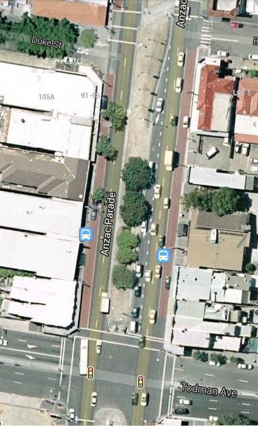
Bus services that will be forcibly terminated at the Kingsford tram terminal transfer passengers to privately-operated cattle cars but the tram rails make it physically impossible for them to turn around. Buses must travel on empty until it is physically possible to turn around. This is not until the buses have passed through the newly created "pinch points" at the Strachan Street stop and the revised UNSW stop above. We can deduce: not until Todman Avenue. The University of NSW is the nigger in the wood pile for Anzac Parade having built the sheer glass facade of the foyer of the NIDA theatre on the plot boundary opposite the "Square House". Pavement widths and lane widths must be reduced on either side of the stop.
Once a bus reaches Todman avenue there are extra lanes and alternative routes along Todman Avenue and Doncaster Street, but this is where O'Farrell will terminate bus services to force passengers to transfer from public buses to privately-operated cattle cars. TfNSW has refused to disclose how buses will physically turn around at this terminus prompting the submissions pleading for more information; but one can deduce that buses will be forced to turn right into Todman Avenue and return to Anzac Parade along Doncaster Avenue - the triangle of roads that TfNSW regards as a bus terminus.
Drivers in NSW are expected to move forward to the centre of the intersection in preparation to efficiently make a right-hand turn - I failed a driving test for being ultra cautious and not moving forward. Parsons Brinckerhoff have as usual omitted the arrows on the lanes but the number of dashes between the lanes reveal that the right-turn lanes at Todman Avenue are not hook turn lanes. It will be physically impossible for drivers turning right to not "encroach on the light rail alignment". When they see a cattle car bearing down on them, with priority signalling, in their rear-view mirror they will have nowhere to go, trapped by vehicles behind them that have moved forward with them. Bus drivers of every bus service forcibly terminated at the Kingsford terminus, in particular, will be sitting ducks. Their only hope for survival will be to clamber over the Opal Card reader in time.
The pupils at Kensington Primary School (cropped by Parsons Brincherhoff) have for generations been protected from heavy traffic since there is no right turn from Anzac Parade northbound into Todman Avenue. They will be experiencing trauma at regular occurrences since this murderous right-hand turn is the only access to Alison Street from Anzac Parade. Indeed, when buses reach their terminus at Todman Avenue the only passengers still on board will be students and staff of the school and parents escorting their children to and from school. O'Farrell really has it in for primary school children.
 |
| Melbourne bus driver console |
 |
| Todman Avenue intersection |
One lane is insane

Every bus terminated at Kingsford terminal has to travel to Todman Avenue to physically turn around. As pointed out in numerous posts the number of buses "removed" from the critical portion of Anzac Parade from Nine Ways to Todman Avenue is zero. TfNSW has promoted the trams as necessary to relieve congestion in bus lanes in Anzac Parade but the trams will undeniably make congestion a lot worse. With the public servants at TfNSW we are not dealing with rational human beings.
 TfNSW is proposing to build bus bays into the car park alongside NIDA and under the cantilevered wings of the newly completed Tyree building - no one would accuse the University of NSW of thinking ahead. When Frank Sartor was Lord Mayor Sydney City Council installed kerb blisters in Elizabeth Street at Martin Place, causing massive disruption over a long period. This turned the bus stop lane into a bus bay. Bus drivers would stop in the next lane out from the kerb to avoid being trapped indefinitely by traffic queuing at the traffic lights at the pedestrian crossing. Eventually this lane was made a bus priority lane and buses now use the bus stop lane, but general traffic is forced into one lane.
Elizabeth Street at Martin Place is a wider section between the "pinch points" at the Old Supreme Court Building and Phillip Street, and leads only to the dead end of Circular Quay, so this is not all that significant. Anzac Parade, on the other hand, is the only arterial road between the south eastern suburbs and Eastern Australia from Kirribilli and Cape York and TfNSW is reducing it to one lane for general traffic in the same manner as Elizabeth Street, creating "pinch points" at the UNSW and at the Strachan Street stop. This effectively reduces traffic flow in Anzac Parade to one lane for the critical section from Nine Ways to Todman Avenue. The mid-block crossings in the revised indicative plan have a lot more potential than a right turn into Day Avenue.
Residents of the south eastern suburbs will be paying a high price for the shortsightedness of the University of NSW, unless their only goal in life is to travel to Circular Quay.
The inherent problems in Anzac Parade at the University of NSW are exacerbated and basically originate in the design of the Kingsford terminus and the associated redesign of the Nine Ways intersection. There is no fundamental reason why a tramway cannot be built from Maroubra Junction to Central Station, as suggested by Infrastructure NSW, and to Circular Quay, as outlined in my submission. But first, we the people will have to elect a competent and socially conscious state government.
 |
| Newly completed Tyree building |
Elizabeth Street at Martin Place is a wider section between the "pinch points" at the Old Supreme Court Building and Phillip Street, and leads only to the dead end of Circular Quay, so this is not all that significant. Anzac Parade, on the other hand, is the only arterial road between the south eastern suburbs and Eastern Australia from Kirribilli and Cape York and TfNSW is reducing it to one lane for general traffic in the same manner as Elizabeth Street, creating "pinch points" at the UNSW and at the Strachan Street stop. This effectively reduces traffic flow in Anzac Parade to one lane for the critical section from Nine Ways to Todman Avenue. The mid-block crossings in the revised indicative plan have a lot more potential than a right turn into Day Avenue.
Residents of the south eastern suburbs will be paying a high price for the shortsightedness of the University of NSW, unless their only goal in life is to travel to Circular Quay.
The inherent problems in Anzac Parade at the University of NSW are exacerbated and basically originate in the design of the Kingsford terminus and the associated redesign of the Nine Ways intersection. There is no fundamental reason why a tramway cannot be built from Maroubra Junction to Central Station, as suggested by Infrastructure NSW, and to Circular Quay, as outlined in my submission. But first, we the people will have to elect a competent and socially conscious state government.