Showing posts with label Devonshire Street. Show all posts

Wednesday, 5 August 2015

Under Constance attack

The infamous Parsons Brinckerhoff was commissioned by the Ministry of Transport, Sydney City Council and Landcom to prepare a Transport Management and Accessibility Plan (TMAP) for the Green Square development area. The report was published in November 2008. The illustration above is typical of the crude scrawlings on UBD road maps that abound in the report.

The situation degenerated into farce when the City of Sydney commissioned a report for the Council of Capital City Lord Mayors. The report from the Allen Consulting Group, dated 2 July 2013, calculated the enormous benefits to the national economy that would accrue from Clover Moore's pet projects: light rail from the CBD to Mascot airport, pedestrianisation of George Street and bicycle paths along CBD roads. The light rail was described only as passing along Crown Street and Baptist Street, then parallel to South Dowling Street, somehow.

The nutters at CoS appear to have assumed the tram rails would have passed down Foveaux Street, the green and dotted-red line on the PB map, but it is far too steep. Clover Moore takes down reports when they are shown to be ridiculous but this report was for CCCLM.

The route along Crown Street has been rendered impossible by the Devonshire Street tram rails - the only entry to the Surry Hills ghetto from the east is from Crown Street.
An alternative route along Riley Street, Malborough then Young Street is blocked by the Surry Hills tram stop. Marlborough Street is also the only exit from the ghetto to the east.


Artists impression of tram rail crossing South Dowling Street

The drawings of the tram rails crossing South Dowling Street released by the State Government would rule out tram rails along South Dowling Street - a driver would have no chance of seeing a tram emerging from the tunnel portal. This leaves only one possible route for trams to branch south towards Green Square and the rest of south Sydney: Bourke Street is doomed.


Devonshire Street at Bourke
The State Government has vehemently opposed a tram service to the south but now Constance is asking the demented Clover Moore for her support for an undisclosed route.

The reasons why the state government opposed a branch to the south are understandable. A branch in the critical section in Surry Hills would mean that only one in three, or less, trams would reach the terminuses at Randwick and Kingsford. The extra wait for trams at the terminuses would make interchanges to and from buses even more unpopular.
Shuttle services between Moore Park and Central Station, if these were ever viable, would be fraught with even more peril by the need to maintain head ways with trams from the south entering the rail section at random intervals. Patrons at events in Moore Park and Royal Randwick would have an even longer wait to clear the grounds.

The other problem is the short radius of the curve needed for trams to branch south from the Devonshire Street rails. This can be seen in the alignment diagrams inadvertently released by CoS. The EIS contained spurious calculations purporting to show that trams could be given priority signalling when crossing South Dowling Street and by inference Bourke and Crown Streets. The trams are expected to be travelling at top speed here. A tight curve would throw these expectations into disarray.


The question remains

If tram rails cannot branch south from the Devonshire rails the old question remains: How do tram rails in Bourke Street connect with the CBD?

  • Foveaux and Albion Streets are too steep for tram rails.
  • Campbell Street is blocked from connecting to the George Street rails by the Chinatown stop. Campbell Street is to be used to turn round buses forcibly terminated in Pitt Street. There would be no connection to Central Station and Railway Square.
  • Bourke Street is too steep for trams north of Oxford Street.
  • The unlamented Chris Lock insisted that trams in Oxford Street would have to double back along Wentworth and Elizabeth Street to reach a sine qua non tram stop in Chalmers Street. Liverpool Street is the only connection for vehicular traffic from the Eastern and South-Eastern Suburbs with Darling Harbour and Barangaroo.

What is Constance on about?

Constance has been placed in a hole by his leadership-rival Gladys. It is a real cat fight. His response is to try to dig himself out by digging the hole deeper. The only possible outcome is for Public Transport south of the Harbour to cave in on him. Gladys eventually produced a vague map of the route and shrieked at  a public forum: "No change is possible". Constance has not given any information about his planned route and is treating it as just a matter between him and Clover Moore.

Constance craving

The dilemma he faces was obvious from the beginning and was the reason for me becoming involved in the quest to save Sydney from this catastrophy. Chalmers Street is not only the main arterial road for traffic between and South Sydney and Botany and the Eastern Suburbs, it is the only route for buses to enter the CBD from these areas. As pointed out in previous posts, it performs these functions with minimal distruption. The earliest artist's impressions were unclear as to how many lanes would be available for these functions and Berejiklian refused to answer Questions on Notice.

The EIS was deliberately fraudulent: descriptions by the consultants were contradictory, leading me to confront Pizza Boy Jeff Goodling, to no effect. The government went on to produce a modified EIS that was never exhibited. Buses from South Sydney and Botany would be trapped in a bus bay by vehicles turning into the one lane into Eddy Avenue or proceeding along Elizabeth Street. It was never revealed how the buses would physically turn around when they eventually made it through the intersection that was predicted to have the worst possible Level of Service. Bus services from Botany, South Sydney and Cloveley will be stuffed by the trams, unequivocally. This is the dilemma that the citizens of Sydney have to face.

Constance is thrashing about in the hope that the nutters at City of Sydney can provide him with an answer to the problems created by Ms Berejiklian. There is however no feasible solution to the problems - nothing will come of it. Constance's political career is in its death throws.

Sunday, 16 November 2014

Missing in inaction

Where's the Central Station bus stop?
The EIS for the Sydney City Centre Bus Infrastructure showed the existing bus stops on the northern side of Eddy Avenue and in Pitt Street and Chalmers Street but the very highly used stop on the southern side of Eddy Avenue adjacent to the pedestrian crossing from Belmore Park to the concourse of Central Station is conspicuous by its absence. The pedestrian crossing is shown dog-legged, inexplicably.

This stop sets down passengers from the Bronte via Oxford Street route (378), the Kings Cross/Elizabeth Bay route (311) and the Mascot via Chalmers Street route (305) as well as the south-eastern suburbs bus services to Railway Square via Chalmers Street (372, 393 and 395). Are these services to be obliterated as collateral damage in order to force passengers from public buses and onto the privately operated trams?

Passengers set down at Central Station
This mainly set down only stop would be the busiest stop for the Bronte bus service. The stop would also be crucial if Clovelly (339) and north Coogee (374) bus services were squeezed out of Elizabeth Street. The stop was seen to be under dire threat when Sydney Council inadvertently released Worksite figures after the exhibition period which did not show the pedestrian crossing and the threat was compounded when the traffic lane giving access to the stop was converted into a bicycle path in the never-exhibited EIS.

The reason Baird is hell bent on crippling the south-eastern suburbs bus services to the Devonshire Street tunnel entrance to Central Station is obvious. The bus services run the pants off the privately operated trams, and most passengers have a seat. Buses forcibly terminated at the Kingsford tram terminus have to travel to Todman Avenue Kensington at least in order to physically turn around. They have then travelled a third of the distance they would travel to Devonshire Street. What is the point?

It should be pointed out that if the Pitt/Castlereagh Streets tram loop was restored this stop would allow more bus services from the south-eastern suburbs as well as from Clovelly and north Coogee to terminate at the Lee Street layover using the under-utilised Foveaux Street bus lane as well as Chalmers Street. Passengers would transfer to the trams in complete safety. Restoring the tram loop would cost less than a quarter of what the George Street trams will cost.

Notley-Smith & friend
It should also be noted that the Member for Coogee Bruce Notley-Smith was in on it from the get go. He was listed as one of the members of the Round Table in the Dec 2012 brochure. On March 1, 2013 he posted comments on his taxpayer funded web site: "Just in time for Mardi Gras, NSW Labor has finally come out of the closet with their position on one of the NSW Government's key transport projects. In a speech on Thursday, the Labor Leader John Robertson told a rail conference the NSW Government's light rail from the Sydney CBD had 'dubious public benefit' and Labor would prioritise the Hunter and Western  Sydney over parts of the city that are comparatively well served".

There were no people or authorities with expertise transport planning or town planning consulted by the "Round Tables" or present at meetings. There were just minor politicians and their public servants. From the very beginning the project was set up for party-political point scoring.

Notley-Smith has never shown any concern for his constituents:

  • He has never questioned what was planned for the Bronte bus services.
  • He has never objected to the only arterial road into Coogee being reduced to one lane with an inescapable right turn at the end.
  • He has never objected to buses being run down by now-nine-segment trams in High Street.
  • He has never given out any information on how buses will physically turn round after being forcibly terminated at High Cross park.
He has been in on all the decisions that will create traffic congestion on access roads into Coogee and cripple bus services from Bronte, Bondi and Clovelly that run along Elizabeth Street.

Fortunately residents in the Coogee electorate will be able on 28 March 2015 to correct the mistake they made four years ago when he was elected.

Tuesday, 28 October 2014

And then there were nine

Protest rally outside Parliament House May 3
At the beginning of May I attended a rally outside Parliament House. That's me holding the sign DANGER NEW TRAMS TOO BIG FOR CITY STREETS.

The yellow and black do-not-cross tape was unfurled to show the length of the proposed trams - it goes on and on. The rally was to support the successful motion of Penny Sharpe for the release of documents which was referred to in a post at the time. I mentioned to people at the rally that Ms Berejiklian had made some remarks offstage that the length of the trams could be increased from seven segments to nine segments. No-one believed that this could happen. The people at the rally from Kensington and Surry Hills were decent, community-minded individuals. They were unable to comprehend the evil that lurks in the hearts of North Shore politicians.

On Thursday 23 October 2014 Ms Berejiklian posted a media release announcing the selection of a preferred bidder for the project:

The announcement merely referred to a 50% increase in the alleged capacity of the system from the oft chanted 9,000 passengers per hour in each direction that TfNSW claimed could be delivered to Circular Quay. Since the wildly optimistic projections of consultants Booz & Company were that the sum total of people on board the trams at Circular Quay during the morning peak would be 764 with only 565 boarding during this period this claimed increase in capacity was inexplicable.

It was not until the following Monday that Ms Berejiklian fessed up that the trams would be increased in length to meet the demands of the preferred bidder, The Connecting Sydney consortium. There is no further information about the trams the consortium will import from overseas.

I had written to the Minister the day after the Community forum at Sydney High in April 2013 saying: "The carriages are the length of five buses. Running these behemoths through a shared pedestrian/cyclist precinct that runs at least 40% the length of George Street can only be described as insane. Running them past children's playing areas in Ward Park is even crazier. There is no precedent for such a system any where in the world. Only New South Wales produces politicians insane enough to even consider a project like this". You can read my letter here.

At the "Information Session" at Surry Hills I asked the tech guy what emergency braking system would be used by the trams only to be told that would be left to the Private Partner to decide and would depend on where the consortium chose to source the trams.

Photoshopped illustration
Needless to say, I raised objections to the total neglect for pedestrian safety from Crown Street to George Street in my submission to the EIS as well as objections to the shared bus/tram lanes at Fiveways intersection. I have archived my submission here. There were many other submissions to the EIS (20% of submissions) that raised these objections. The subverted public servants at Planning and (now) Environment acknowledged in the Assessment Report: "Public safety has been identified by the community as a key concern. The Applicant has recognised this and has provided an assessment of the safety for all road users including pedestrians, passengers, operators and the general public during both construction and operation phases".

In fact, the only response to the numerous objections about pedestrian safety in Surry Hills and Kingsford by the Department was to included a photoshopped revision of the notorious illustration of trams passing the Shakespeare Hotel in Devonshire Street without any commentary in the text. The Assessment Report went on to deal dismissively with concerns about safety in the pedestrian zones in George Street, Moore Park stop, Royal Randwick Racecourse stop and UNSW stops in section 5.2 Public Safety but there was nary a word about Surry Hills and Kingsford.

By increasing the length of the trams Baird will be blindsiding pedestrians at every crossing leading to and from Central Station far more comprehensively. This was 46,000 passengers in the 3.5 hour morning peak alone in 2011. With this many people the carnage in the killing field from Crown to George Street will be inexorable. The coupled juggernauts will be 18 segments long, posing far greater danger to residents at Northcott Place.

Baird's only reason for doing this is because corporations submitting proposals for owning and operating the trams believe (ludicrously) that this would be necessary for them to make a profit. If the best proposal was from Connecting Sydney corporation the other submissions must have been bizarre.

Friday, 13 June 2014

Shakespeare Hotel update

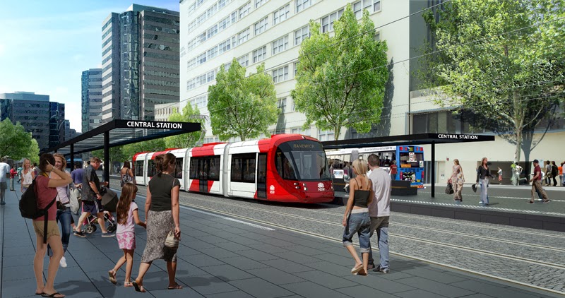
It was this computer generated artist-impression of a coupled juggernaut roaring through an intersection outside the Shakespeare Hotel in Devonshire Street published in the first brochure in December 2012 that most demonstrated the utter indifference of the North Shore Liberal Party rump to the lives and livelihoods of people living south of the Harbour. The tech guy I spoke to at the Information Session during the exhibition period was deeply embarrassed by it. Clover Moore embraced the picture and included it in countless ratepayer funded letter drops.

Now the Final Secretary's Environmental Assessment Report has published gratuitously an updated version of the infamous picture. The picture does not relate to anything in the text of the document - it is just a random illustration in a report that contains very few illustrations.

The length of the approaching vehicle does not appear to have changed but the sign on the front indicates that it cannot be a coupled tram. The existing trees have been removed and replaced by fully grown trees and the reason for this is shown - the poles supporting the overhead wires.

The picture has been widened to show a vehicular traffic light that can only be seen by westbound tram drivers. The light is red to indicate that the eastbound tram is in fact stopped even though there are no pedestrians crossing and no pedestrian crossing lights or buttons. This is deliberately deceptive since TfNSW has said that trams and juggernauts will race through Surry Hills at 60 kph with priority signalling.

This crossing is about 50 metres from a crossing at Little Riley Street that gives access to the platform of the tram stop and none of the pedestrian crossings planned for Devonshire Street are close to the main pedestrian arteries which are along Riley Street and Clisdell Street.

This picture was not included in the EIS that Planning and Infrastructure were supposed to be assessing. The public servants in Planning and Infrastructure who prepared the Assessment were even more deceptive than the consultants that wrote the EIS.

The Minister for Planning and Environment Pru Goward has joined the sisterhood. Is there no minister in the Baird Government that is not systemically dishonest?

Sunday, 18 May 2014

"Run over the bastards"

Five segment tram
I asked the tech guy at the final "information session" before the close of the exhibition period what kind of emergency braking will be used by the LRVs. He said that that would be left for the PPP (Public/Private/Partner) to decide. He also claimed that current trams could stop in the same distance or better than rubber-tyre buses - not physically possible. In the past some trams used electromagnetic controlled blocks between the wheels of the bogies that dropped onto the tracks to dissipate kinetic energy but modern trams use the equivalent of ABS braking on rubber-tyre vehicles to stop them going into the infamous death slide where the driver saw the tram accelerate as the wheels locked. The point at which antilock braking cuts in depends on the friction between the small-diameter steel wheels and the steel track. This depends on whether the track is wet or dry and on the cleanness of tracks level with the road surface but it is low - Chris Lock told the meeting at Sydney High School repeatedly that trams cannot go up grades greater than 7% as they "cannot stop". They cannot swerve to avoid a collision as well.

Hey Kids, ain't trams fun to play with?
Goldlinq tram cutout
The companies that manufacture segmented tram chassis internationally are few and far between but their web sites give no information on emergency braking, and what would be the point of speculating on where the PPP would source the trams. The Gold Coast is the only place in the world that will run seven segment trams, in small part, through existing streets so we will use this as an example.
The Gold Coast trams are undergoing testing for safety this year. Kid's activity packs and colouring-in books have been issued and school kids are being lectured on the "science" of trams. Queensland is the only state where tradies died through not turning off the power when installing ceiling insulation so safety would be an important consideration. Contrary to the conventions of the Westminster System, North Shore politicians set up a Royal Commission and released redacted Cabinet documents. The former Prime Minister Kevin Rudd successfully had restrictions on the information removed and in his testimony did not suffer the "massive memory losses" experienced by Sinodinos and O'Farrell and other politicians at ICAC hearings. The Royal Commission has given family members of the four workers who died a multimillion dollar platform to rend their sackcloths, but more importantly, under the tit-for-tat rule of politics, a Royal Commission into Transport for NSW following the inevitable deaths and serious injuries by trams will be able to access the Cabinet deliberations of the Baird government if the Project is approved.
Tram stopping Gold Coast traffic
The safety campaign states that safety is a shared responsibility but the message is that if you are hit by a tram it is your fault. This will no doubt be challenged by contingency law firms - the PPP is apparently being indemnified by the State Government and Gold Coast Council. The web site emphasises that the tram tracks are separate from the from the road tarmac and have a different colour. For the most part the tracks are completely separate from the road system, having their own bridge across the Nerang River and travelling alongside the Gold Coast Highway.
Gold Coast Hospital, Nerang Street 
The exception is where the trams make a dogleg along Nerang Street and Scarborough Street to provide stops at the Gold Coast Hospital and the Southport city centre. The stop at the hospital occupies roadway formally used for 90 degree central parking - the tracks are separated from the roadway with raised kerbing except for the ambulance-only crossing (top right). There are separate lanes for turning and straight-through traffic at the few minor crossings where right-hand turns across the tracks are permitted. The differences between the situation in High Street at Prince of Wales Hospital could not be more stark.
 
The stop at the hairpin bend into the Southport retail centre is the only place in the system where the trams pass through a pedestrianised area - it is only one block long. Pedestrians are being instructed to cross the rails only at signalised crossings. The black lines presumably represent where trams are required to stop when pedestrian movements are taking place. It is of course physically impossible to stop people crossing the rails at tram stops but the crossings are at the natural pedestrian paths. In Devonshire Street the only signalised crossing between Crown Street and Elizabeth Street will be at Marlborough Street which is not and never will be a pedestrian path. Contingency lawyers will have little difficulty in arguing that it was not a realistic expectation for pedestrians to divert to this crossing.

The light rail feasibility study

The Goldlinq project had a long gestation period. It was first mooted in a Gold Coast City Council Transport Plan in 1996 and the Queensland and Federal Governments funded a professional feasibility study in 2002 - the draft summary report was released in 2004. Alignment diagrams for the entire route have been published and show the lane direction arrows in adjacent roads. The Queensland Government committed $464 million to the project in 2009 supplementing $365 million provided by the Federal Government and $120 million from the Council and contracts were awarded in June 2011.

In NSW the route for a light rail project was determined on the whim of the then Premier. The project has never been subjected to a feasibility study and has never been endorsed by successive Federal Governments. Alignment diagrams for the portion of the route through areas in the jurisdiction of the Sydney City Council were inadvertently released in the Council's submission for the EIS but these have been superseded in the Preferred Infrastructure Report.

"There are winners and losers"

The Deputy Director General Transport for NSW Chris Lock told the Randwick Business breakfast in April 2013 that there are winners and losers. I for one had already raised concerns to the Minister about the unacceptable hazard that the design would impose on pedestrians and passengers - the losers would not only be those who lost their livelihoods but also those who lost their lives. There has been no attempt to address these concerns.

Tuesday, 8 April 2014

One lane is insane 2

The indicative plan of the Randwick terminus in the EIS was rotated and cropped to conceal the layout of southbound lanes in Belmore Road adjacent to the Highcross Park tram terminus. It clearly showed a northbound general traffic lane alongside a bus stop lane. It showed trams entering and leaving the terminus on different rails despite there being points for switching between rails in front of the Oncology Department at Prince of Wales Hospital. Parsons Brinckerhoff are implying that trams will be arriving alternately at each platform.

In the Technical Papers 5.4.5.4, Booz & Company gave a completely different description of the terminus. The northbound lane was designated as bus only and the southbound lane was not defined further but was required to provide access to properties. The most startling difference however was the tram stop, which was island platform.

The switch points for changing rails are closer to the intersection and the outbound and inbound points are more widely separated, and it is made clear that only one of the rails into the park would be in use at any one time. Which of the rails that would be in use would depend on the time of day, the northern rail would be in use for the "AM peak" and the southern rail at the "PM peak" and it would be anyone's guess which rail was in use throughout the rest of the day and night.

When the Randwick stop was just a dot on an indistinct map, posts on this blog speculated on whether buses would go with the flow of the Cuthill Street sling-shot or go against the flow, with dire consequences. Booz & Company reveal that TfNSW intend to do both, whatever the consequences for traffic flow in the Randwick traffic arteries. Incredibly, they would have you believe that buses would use the alignments of the unused rail to make turns into and out of High Street. Buses of course have to make return journeys throughout the day.

Less cropped plan of High Cross Park stop
Needless to say Randwick Council in its submission stated its opposition to the terminus in High Cross Park: "The Council is opposed to the High Cross Park design as detailed within the EIS... Council supports ongoing discussions to progress detailed study and modelling of the relocation of the Randwick interchange from High Cross Park to the eastern end of High Street opposite Prince of Wales Hospital".

The response of TfNSW has been to reissue a somewhat less cropped version of the plan in the EIS. The northbound lane in  Belmore Road is now depicted as bus only and bizarrely the trams in High Road and the terminus have switched rails. Parsons Brinckerhoff still insist the trams will arrive at alternate platforms, still contradicting Booz & Company.

The less-cropped plan reveals for the first time that there will be a single lane for southbound traffic in Belmore Road to carry all the traffic from High Street, the section of Belmore Road through the retail/civic heart of Randwick, and Avoca Street headed to Coogee Bay Road and Perouse Road. This single lane ends as a right-hand turn into Perouse Road so a vehicle waiting to turn right across the busy arterial Coogee Bay Road will block traffic from entering Coogee Bay Road.

This is the same situation that TfNSW is creating in the single lane in Devonshire Street, which ends in a right-turn into Crown Street, but Devonshire Street is just a local distributor for Surry Hills traffic. Belmore Road has been the sine qua non arterial road from Eastern Australia north of Kirribilli, to Coogee and south Maroubra from the foundation of the colony.

The situation in Devonshire Street was only revealed when Sydney City Council inadvertently released alignment diagrams in its submission, and cropping was also used to with-hold information about the single lane in Belmore Road from the public. Eco-nazis on Sydney City Council and Randwick City Council conspired with TfNSW to with-hold information from the public that will have a profound impact on their lives, for ever.

I railed against the cropping of the plans and the lack of information on Belmore Road in the EIS in posts on this blog but I did not lodge an objection in my submission. In my deluded state I believed that legally you could only object the matters that are disclosed in the EIS. I thought that if I raised objections on the basis of deductions TfNSW could claim they were not obliged to make the data available since it could be deduced.

Apparently the O'Farrell government has obtained advice from the Attorney General's Department that it is legal to make disclosures in a revised EIS months after the close of the exhibition period. Is there no section of the Public Service that has not been subverted by O'Farrell in less than three years?

The double whammy


There has never been a right-hand turn from High Street into Avoca Street, since High Street is two lanes each way. Traffic needing to access Avoca Street is slingshotted from a right turn lane into Cuthill Street at the southern end of High Cross Park. Right turns for general traffic will still be banned so vehicles will be forced to turn into Perouse Road instead. Buses however will be forced to make right-hand turns into Avoca Street. A single bus waiting to turn right will block traffic in High Street from proceeding through the intersection in parallel with the trams - the same old story as in Devonshire Street at Crown Street. But TfNSW acknowledges that High Street is a major arterial. Traffic travelling along High Street to Coogee Bay Road will have to pass through two single lane roads that are inexorably blocked by vehicles making right-hand turns at the ends.

The bus route of death

The exhibited EIS revealed that TfNSW will be terminating some of the Parramatta Road bus services displaced from George Street at Coogee beach via High Street. The revised EIS demands that the assessors just approve the project and allow O'Farrell to tell bus passengers from the inner west where they will be going two or three years after the next state election. Whenever they are informed, Booz & Company has plotted their path through the Randwick terminus.

Parramatta Road bus services terminating at Coogee beach will be forced to cross the tram rails four times, the fourth time is the deadliest. The diagram above of the PM peak shows the buses making an almost 90 degree turn into Avoca Street across the rail active in the morning, according to Booz & Company, or alternately throughout the day, according to Parsons Brinckerhoff. In the words of Vice President Joe Bilden: "not physically possible". It is not physically possible for buses to turn here without "encroaching on the light rail alignment". Not only are bus drivers sitting ducks so are passengers seated in the seats you are asked to vacate for mothers with babies and people with mobility disabilities, who are not able to see cattle cars approaching in the rear-vision mirror. They are in the firing line for cattle cars entering and leaving the High Cross Park terminus.

They are not out of the firing line when the other rail is active. I will refer you to another blog: melbournetramdriver.blogspot.com.au  His second post, in July 2011 "No steering wheel" is relevant to the matter. The google streetview figures below are from this post.


Hawthorn Road in Melbourne
Melbourne tram drivers have shoulder-high "tuna-can levers" for switching between rails but the more heavily used points are of course automated. The driver indicates the direction he wants to go between the first dot and the second pair of dots. The default position is straight ahead. In a tram system the points are vulnerable to vandalism and general failures from weather. In the event of failure of the switch between rails the trams would go straight ahead and take out buses that assumed the other rail was in use - no passenger would be spared.

There are of course no parts of the Melbourne tram system where trams are forced to switch between rails, as close together as physically possible, just before a very busy intersection when travelling at the speed limit of 60 kph, we are told. Trams will be travelling in each direction over the single rail into the Randwick terminus every two minutes as there are only two terminuses in the system. Only New South Wales produces politicians insane enough to contemplate such a system.


Friday, 28 March 2014

Out damned spot!

Gladys Berejiklian
Actress as Lady Macbeth
Shakespeare Hotel,  Devonshire Street
The "artist's impression of light rail on Devonshire Street, Surry Hills" in the December 2012 brochure left me appalled. The brochures were thrust upon everyone attending the Community Forum at Sydney High School and this computer-generated view of the Shakespeare Hotel at Steel Street was used in countless ratepayer-funded letter drops from Clover Moore.

The Minister for Transport and Moore sat alongside the Deputy Director General TfNSW Chris Lock as he explained at great length that trams could not go down slopes greater than 7 metres in 100 metres because they "could not stop". Neither of them showed any signs of twinges of conscience about the situation the innocent pedestrians depicted would be forced to face.

I was surprised that I have not included this figure in a post and since this is a blog of record I will do this now. The white line across the road is the artist's standard way of depicting a pedestrian crossing and is where the current zebra crossing is situated. There can never be barriers to block off this crossing as they would be demolished by trucks turning left from Steel Street into the narrow single lane of Devonshire Street - it will always be a de facto crossing.

The tech guy at the final "information session" was embarrassed by this notorious figure and asked: "How does this differ from the current situation?" I pointed out that there was now very little traffic at the time when people are wending home from the entertainment ghetto to the dormitory ghetto but trams and coupled juggernauts would be passing through every two minutes in either direction - on average one every minute.

AFL games are held to meet television schedules. Friday Night games start at 7:50 pm and end around 10:30 pm which coincides with the peak period for bus services in the cinema/night club strip in George Street and trams have to travel to the Randwich or Kingsford terminuses to turn round. The trams and juggernauts would still be running at their peak until 12:30 am at the least.

The artist erred in not erasing the trees from his figure. Clover Moore told the forum that these would all be retained but the EIS has singled them out for removal.

Wednesday, 26 March 2014

Not just sociopathic - psychopathic

Ward Park alignment diagram (superseded)

Superseded stop
When I came home from the Community Forum at Sydney High School in April I was unable to sleep. I had looked into the jaws of death and seen callous indifference to the lives of others.

The following day I started composing a letter to the Minister. I wrote: "Running these behemoths through a shared/cyclist precinct that runs at least 40% the length of George Street can only be described as insane. Running them besides children's playing areas in Ward Park is even crazier. There is no precedent for such a system anywhere in the world. Only New South Wales produces politicians insane enough to even consider such a system."

A couple of months later, at the beginning of June, I and everyone else who had written in to express their concerns received a standardised letter thanking us for our interest. Chris Lock would become a recluse and the Minister would refuse to answer any questions in Parliament on the project.

Booz & Company modelling
Booz & Company in the Technical Papers expected vast numbers of train passengers to walk to the Ward Park stop to catch a tram rather than risk live and limb crossing the tram tracks blindsided at Chalmers Street - a reasonable assumption. Now TfNSW is claiming this was a terrible mistake, or as Pizza Boy Jeff Goodling would say "an inadvertent mistake". They have produced a "corrected table":
Revised peak AM boardings
Every figure except three in the diagrams is different, although some are startlingly similar - projected boardings at Moore Park change from  216 to 215 despite the stop being moved substantially to the south. TfNSW claim to be able to predict passenger numbers in 2021 to the last passenger. The Opal Card would provide origin/destination data on a daily basis, but without such data the figures bandied about by TfNSW and its consultants are just gibberish.

Proposed design change of Surry Hills stop

I would like to show a figure of revised plan of the Ward Park stop but it does not exist. The changes are just described cursorily in text in section 6.6 in the Preferred Infrastructure Report. Instead of an island platform "the new platform configuration would provide two 2.8 metre wide, 45 metre long side platforms". TfNSW falsely claims the design is similar to the design in the EIS in providing "a pedestrian crossing at each end of the stop and would be compliant with the Disability Discrimination Act 1992 (DDA)". In the design in the EIS, the alignment diagrams released inadvertently after the close of submissions show that the space between the rails is reduced to a point before reaching the Marlborough Street crossing - a disabled passenger would need a very narrow wheelchair to avoid being crushed between trams departing and arriving at the stop!
The problem with both designs is that the crossings are designed solely for the benefit of the tram operator and have no relationship to established pedestrian movements in Surry Hills. The current crossing is of course at Riley Street and the platforms lie across it. The EIS assumed a planting strip would deter people from crossing here and force them to dogleg to the prescribed crossings!

The provision of a platform between the rails and the single vehicular lane will make it much more likely for pedestrians to cross across the platforms. The vehicular lane will be grid locked all day and most of the evenings because movements are blocked by any vehicle turning right at Crown Street. Pedestrians will just have to walk through stationary vehicles.

People waiting for a tram to pull out from the platform so they can walk behind it, regardless of whether they alighted from one of the five doors of a tram or are pedestrians trying to cross between the Surry Hills ghettos, will be blindsided to a tram or juggernaut passing through in the other direction because the tracks curve into Ward Park. I asked the tech guy at the "Information Session" how far from the side of a tram would someone have to stand to see an approaching tram. He said the Private Partner would have to produce a safety plan before beginning operation - this was reiterated in the EIS.

The revised design exposes people crossing the tracks to far greater danger since there is now no buffer between the tracks - the moment someone steps out from behind a tram, splat. They won't hear it coming as trams are noisiest when accelerating from rest. There is no way that people can be dissuaded from crossing the tracks to get to the outbound platform or to get to the northern Surry Hills ghetto. The EIS states that heavy rigid vehicles would encroach on the light rail alignment in making left-hand turns at the few streets where this would be allowed. With the revised design they will be encroaching on the platform and they would demolish any pedestrian barriers designed to  prevent crossings at Riley Street.

The section figure prepared by Parsons Brinckerhoff shows children and dogs frolicking in Ward Park with just a step down to the footpath separating them from the tram rails. The revised design reduces the width of the footpath by around one metre we are told and ensures there can never be barriers to stop children running across the platform and onto the rails.

It is physically impossible for a PPP to reduce the dangers to pedestrians and passengers in Devonshire Street, Chalmers Street and Eddy Avenue. There will be a continuous killing field from Crown Street to George Street.

So, will the O'Farrell government indemnify the Private/Public Partner that knowingly constructs and operates a tram system that exposes pedestrians and passengers to levels of hazard that are not considered acceptable anywhere in the world from being sued by people injured or the relatives of people killed? Will it provide the PPP with an Ellis defense exonerating it from the acknowledged faults in the system? Would this expose the NSW taxpayer to an open-ended liability to litigation?

Government Information requests refused on grounds of commercial confidentiality.

Friday, 21 February 2014

The murderous ploy of the wicked witch

Chalmers Street alignments
M20 route
Currently the Metrobus services from Coogee and Maroubra Junction (M50 and M40) and the bus services from the South Eastern Suburbs that terminate at Railway Square set down passengers at the Devonshire Street entrance to the Central Station platforms. The Metrobus service from Botany (M20), as shown in the route map left, does the same. Passengers wishing to transfer to a train service walk efficiently and completely safely to the appropriate platform.

As you can see from the alignment diagrams inadvertently released by Sydney Council there is no earthly reason why they could not continue to be set down here. The stop is to be obliterated (except when coupled juggernauts are operating at special events) to compel bus passengers to cross two tram rails in order to transfer to a train or a tram. This is nothing more than a ploy by the Wicked Witch of the North to dissuade public bus passengers terminated at Eddy Avenue from catching a train to Town Hall, Wynyard and Circular Quay. It is hoped that instead they will transfer to a privately-operated standing-room-only tram that travels at pedestrian speed to the same destinations.

This is surely a forlorn hope. Any bus passengers silly enough to succumb to this ploy will alight from their bus and look to see if a tram is approaching round the bend from Devonshire Street. If one is, they will make a frantic dash across the tracks to the opposite platform. Tragically, they would be unlikely to see a tram zipping round the corner from Eddy Avenue.

When Parramatta Road bus services are terminated at Coogee, along the old M50 route, this will be likely to occur more frequently.

Rawson Place stop
The Rawson Place stop is just as murderous. The President and Vice Chancellor of UNSW, Fred Hilmer, in his submission reported that their Facebook page alone had received several hundred positive comments or actions. The student body is composed of students who did not get the grades to go to a real university. Students and others needing to transfer from a 45 metre long tram to a bus service forcibly terminated at Rawson Place will alight from one of the five doors of the seven-segmented tram and wait for the rear of the tram to pass them, then cross to the northern platform to catch their bus. They will be focused on the buses pulling in or waiting at the stop. They will not see or hear the tram zipping round the corner from George Street.

O'Farrell has never shown any concern for the lives of people living south of the Harbour so it is probably worth pointing out that every time a tram hits someone or something or breaks down the CBD will be effectively shut down for an indefinite period.

It should be pointed out that O'Farrell and the Minister for Transport have been informed of tramway designs that do not pose the dangers to pedestrians and passengers that are inherent in this incompetently-designed tramway.

Friday, 31 January 2014

The Green and Black


The Green and Black
I confronted the Project Director, Jeff Goodling, about the contradictions in the various plans in the EIS at the community meeting shortly after the EIS went on exhibition. The Lord Mayor of Sydney and the Member for Sydney were conspicuous by their absence at the meeting, so they may not have been aware of the contradictions and deliberate deceptions in the EIS.

I am not alone in drawing attention to the many contradictions in the EIS, this is an extract from the submission of Kingsford South Precinct, one of the resident groups sponsored by Randwick Council, on page 22 of website submissions here http://majorprojects.planning.nsw.gov.au/?action=view_job&job_id=6042
Note that Randwick Council sponsored community groups to examine the EIS. Clover Moore has embarked on a campaign of letter drops with false information and has maligned community groups with unsubstantiated claims about alternative routes.

Which brings us to the City of Sydney's hysterical response to the the EIS.
Surry Hills ghetto encircled
The Technical Papers state: "To mitigate the impacts to local access the following network changes are proposed: Reinstate the Cooper Street connection to Riley Street to provide access for local residents." This is disingenuous. If Cooper Street reserve in not obliterated the only entry for rag-trade heavy vehicles to the Surry Hills commercial ghetto, from the south, is to circle the entire ghetto - the yellow line on the Google Earth map above. Traffic from Chalmers Street must thread along the single lane of Devonshire Street past the pocket parks closing off Holt and Waterloo Streets and enter from the northern end of Waterloo Street, where it has narrowed. This is simply to avoid the possibility that turning heavy vehicles may "encroach on the light rail alignment" - limiting the speed at which trams can travel through Surry Hills.

This provoked an hysterical response from the City of Sydney. Their submission refers to a table in volume 1A which is a cut and paste of the passage in the Technical Papers. They shriek: "The Proponent should consider that opening Cooper Street will help local circulation but will provide a by-pass from Elizabeth Street to Crown Street."

The recommendation is: "That the reopening of Cooper Street only proceed if the Proponent demonstrates that it is essential to traffic flow and local access."

Neither TfNSW or City of Sydney show any concern for the Child Care centre adjacent to the reserve, that was the subject of a previous post. City of Sydney's only concern is to stop evil motorists from avoiding blocking the only exit to the north from the other Surry Hills ghetto.

A year ago, when it had become a "stakeholder", the Council amended the Local Environmental Plan 2012 to change the zoning of land adjacent to the reserve, resumed for road widening, from General Residential to Public Recreation. O'Farrell could have a fight on his hands.

The obvious solution to all these problems is to leave Holt Street and Waterloo Street open at their southern ends and to slow down the trams in Devonshire Street so they can cope with the odd turning truck. Even better, to not run trams along a road that is too narrow to accommodate them.

Clover Moore's only concern is the maximise the profits of the the privately-operated tram company by letting it ride roughshod over Surry Hills. She is backed up by her acolyte Alex Greenwich (get it), the Member for Sydney, who opines in the submission posted on his web site: "Pocket parks at road closures - These closures must provide high quality plazas and pocket parks at intersections to help green and pedestrianise the area and add to the village atmosphere".

The EIS shows no concern for the employers in this major commercial area of Sydney; only for local residents, who vote at elections. O'Farrell is apparently prepared to do to the rag trade and News Ltd and all the other smaller businesses in the area, what his Federal colleagues are doing to the car industry and the Goulburn Valley.

The community independents have a long history in this area. When they controlled South Sydney Council the area had one of the highest unemployment rates in Australia. When South Sydney was merged with Sydney they took control of the goose that laid the golden eggs. Now, sure enough, they are killing the goose.

Wednesday, 29 January 2014

The Public Service prat

At a community meeting in Surry Hills after the EIS had been released, residents were lectured at length by officers from TfNSW on how their objections should be framed. They should be short and not deal with matters like the proposed Parramatta Light Rail! The officer pictured suggested: "For example, you may wish to object to the right-hand turn from Devonshire Street into Crown Street."

Why would anybody object to this right-hand turn - the only one apart from Devonshire into Elizabeth Street? Since this intersection had been cropped from the figures shown in the EIS, there was no information on which one could base a comment. Now Sydney City Council has inadvertently released alignment diagrams that explain this little mystery.

There is only one lane of traffic in Devonshire Street all the way to the intersection with Crown Street. One vehicle waiting to turn right will block all traffic movements in parallel to tram movements which we are told will be occurring on average every sixty to ninety seconds. There will be vehicles wanting to turn right during most phases when the trams are running - 5am to 1am, supposedly. The only traffic movements in parallel to the trams will be to fill the lane to the intersection. It will take only eight or nine vehicles to block the only exit to the south from the public-housing ghetto - to exit, traffic from Marlborough Street must turn left into Crown or Bourke Streets. This happens often during the weekday evenings, without any trams.
Marlborough Street exit from ghetto blocked, 5:30pm
Not that O'Farrell gives a shit. The alignment diagrams confirm that half the area of Ward Park will be used as a construction site, but holds out the tantalising prospect that this area could be reduced, by a sliver, by blocking off Marlborough Street. This would mean, of course, that there was literally no exit to the north from the Surry Hills ghetto.

The green patch encompasses the church hall of the Roman Catholic St. Peters Church. This building, built in 1880 had its slate roof repaired after the super cell. The tag says Property Adjustment TBA - that is presumably, To Be Announced. Not to be discussed or negotiated with the Church authorities, who first learned they would not be able to conduct funerals when the EIS was released.
 
O'Farrell has as much respect for his Church as he has for the intelligence of residents south of the Harbour.