Showing posts with label Hook turns. Show all posts

Friday, 4 April 2014

One lane is insane

Infrastructure NSW recommendations
The O'Farrell government set up Infrastructure NSW headed by chairman Nick Greiner shortly after gaining office to give independent advice on projects. The advice it received was to build light rail from Central Station to Maroubra Junction, presumably, from the figures they released, subsurface under Foveaux Street since they would have known that Foveaux Street is too steep to take trams. They also examined the idea of running trams along George Street and issued a scathing dismissal of the prospect - some of their milder comments are in the sidebar.

Greiner and his Public Service colleague Paul Broad resigned in May 2013 when it had become clear that loonies had taken control of the asylum.

Loonies take control of the asylum

Revised plan of stop at UNSW
The stop at University of NSW is another stop that has been changed so radically TfNSW has published a whole new set of revised (cropped) indicative plans. The submission of the Randwick Council asked for modelling of the congestion that would occur in Barker Street to the west of Anzac Parade as a result of the tram rails closing the right-hand turn into Day Street. My submission also objected strongly to the closure of right-hand turns at Day Street. TfNSW has not undertaken the requested traffic modelling but asserts in Item 10.1: "Since the release of the EIS, further analysis has been undertaken of the right-turn movements and the space for right-turn bays in some locations is likely to need to be adjusted.
"A design change to the UNSW Anzac Parade stop is proposed comprising relocation of the stop to the centre of Anzac Parade."

The right-turn lane is very short allowing only three or four vehicles or one bus to queue to make a right-turn before the one the only general traffic through lane is blocked. Bus services to Kingsford currently make right-turns here but they will still be rerouted along rat-runs. The revised indicative plan refers to a "potential right hand turn (subject to discussion with RMS)". Roads and Maritime Services is to be Bad Cop who rejects the turn after the Assessors have approved the project, with nothing having been disclosed before the exhibition period closed.

No Hook Turns

The indicative plans of Parsons Brinckerhoff in the EIS were all cropped or arrows on lanes omitted to deliberately conceal whether Hook right-turn lanes would be used to cross the tram rails. There are very good reasons why hook turn lanes are used throughout Melbourne and with tram systems around the civilised world. One of the most important is that it is impossible to stop vehicles waiting to turn right from "encroaching onto the light rail alignment". When a tram with priority signalling inevitably hits such a vehicle the airbags deploy and the vehicle is spun into the path of through traffic travelling in parallel with the tram. When the vehicle is hit in on the other side the airbags are deflating to avoid smothering the occupants - the end of the whole family.


Emasculating Environmental Protection

Section 5.8.1 of the submissions report summarises the large number of "concerns about lack of certainty about changes to bus network" raised in responses to the EIS, and this is fair enough. The response of TfNSW is: "The NSW Government released the final Sydney City Centre Access Strategy (SCCAS) and Sydney's Bus Future in December 2013. These strategies form the basis of the Sydney City Centre bus network and changes to the South East bus network."
Figure 4.2 from EIS (re-post)
The EIS published tables and the figure reproduced again (left) led to the concerns in many of the submissions to the EIS. I raised several objections in my submission, based on the data in the EIS.

Now the only response of TfNSW to all these objections and concerns raised in submissions to the EIS is to ask the Assessors to ignore the data in the EIS and the concerns that arose and to give approval to the project on the basis of brochures that were not included in the EIS and were not released to the public until after the EIS went on exhibition. I do not know when the SCCAS brochure was released in December but the second brochure was released two working days before the exhibition period was due to end.

If this is legal then the EIS legislation has been drained of its life blood and is all but worthless.

The response goes on: "TfNSW will commence detailed planning for the South East bus network in 2016/2017 in preparation for the commencement of CSELR operations". That is, one year after the next state election. The state government has not established that there is any pressing need for O'Farrell's whimsical project - quite the contrary. In my submission I asked the Assessors to not give approval to the EIS until TfNSW has established where bus routes can physically turn around.

TfNSW clearly believes that the Assessors are imbeciles, or it has inside information that the Public Servants at Infrastructure and Planning have been subverted along with those at the monster bureaucracies set up by O'Farrell, RMS and TfNSW.

So where do buses turn around

The trams along George Street obliterate all the places in the CBD where buses can physically turn around except for Phillip Street, but this post deals with Anzac Parade. The concern is listed in Volume 1 Part A Section 5.8.1 as
  • Further information requested about where buses will turn around at Todman Avenue following introduction of the CSELR proposal.
Bus services that will be forcibly terminated at the Kingsford tram terminal transfer passengers to privately-operated cattle cars but the tram rails make it physically impossible for them to turn around. Buses must travel on empty until it is physically possible to turn around. This is not until the buses have passed through the newly created "pinch points" at the Strachan Street stop and the revised UNSW stop above. We can deduce: not until Todman Avenue. The University of NSW is the nigger in the wood pile for Anzac Parade having built the sheer glass facade of the foyer of the NIDA theatre on the plot boundary opposite the "Square House". Pavement widths and lane widths must be reduced on either side of the stop.

Once a bus reaches Todman avenue there are extra lanes and alternative routes along Todman Avenue and Doncaster Street, but this is where O'Farrell will terminate bus services to force passengers to transfer from public buses to privately-operated cattle cars. TfNSW has refused to disclose how buses will physically turn around at this terminus prompting the submissions pleading for more information; but one can deduce that buses will be forced to turn right into Todman Avenue and return to Anzac Parade along Doncaster Avenue - the triangle of roads that TfNSW regards as a bus terminus.

Melbourne bus driver console
Drivers in NSW are expected to move forward to the centre of the intersection in preparation to efficiently make a right-hand turn - I failed a driving test for being ultra cautious and not moving forward. Parsons Brinckerhoff have as usual omitted the arrows on the lanes but the number of dashes between the lanes reveal that the right-turn lanes at Todman Avenue are not hook turn lanes. It will be physically impossible for drivers turning right to not "encroach on the light rail alignment". When they see a cattle car bearing down on them, with priority signalling, in their rear-view mirror they will have nowhere to go, trapped by vehicles behind them that have moved forward with them. Bus drivers of every bus service forcibly terminated at the Kingsford terminus, in particular, will be sitting ducks. Their only hope for survival will be to clamber over the Opal Card reader in time.
Todman Avenue intersection
The pupils at Kensington Primary School (cropped by Parsons Brincherhoff) have for generations been protected from heavy traffic since there is no right turn from Anzac Parade northbound into Todman Avenue. They will be experiencing trauma at regular occurrences since this murderous right-hand turn is the only access to Alison Street from Anzac Parade. Indeed, when buses reach their terminus at Todman Avenue the only passengers still on board will be students and staff of the school and parents escorting their children to and from school. O'Farrell really has it in for primary school children.

One lane is insane

Every bus terminated at Kingsford terminal has to travel to Todman Avenue to physically turn around. As pointed out in numerous posts the number of buses "removed" from the critical portion of Anzac Parade from Nine Ways to Todman Avenue is zero. TfNSW has promoted the trams as necessary to relieve congestion in bus lanes in Anzac Parade but the trams will undeniably make congestion a lot worse. With the public servants at TfNSW we are not dealing with rational human beings.

Newly completed Tyree building
TfNSW is proposing to build bus bays into the car park alongside NIDA and under the cantilevered wings of the newly completed Tyree building - no one would accuse the University of NSW of thinking ahead. When Frank Sartor was Lord Mayor Sydney City Council installed kerb blisters in Elizabeth Street at Martin Place, causing massive disruption over a long period. This turned the bus stop lane into a bus bay. Bus drivers would stop in the next lane out from the kerb to avoid being trapped indefinitely by traffic queuing at the traffic lights at the pedestrian crossing. Eventually this lane was made a bus priority lane and buses now use the bus stop lane, but general traffic is forced into one lane.

Elizabeth Street at Martin Place is a wider section between the "pinch points" at the Old Supreme Court Building and Phillip Street, and leads only to the dead end of Circular Quay, so this is not all that significant. Anzac Parade, on the other hand, is the only arterial road between the south eastern suburbs and Eastern Australia from Kirribilli and Cape York and TfNSW is reducing it to one lane for general traffic in the same manner as Elizabeth Street, creating "pinch points" at the UNSW and at the Strachan Street stop. This effectively reduces traffic flow in Anzac Parade to one lane for the critical section from Nine Ways to Todman Avenue. The mid-block crossings in the revised indicative plan have a lot more potential than a right turn into Day Avenue.

Residents of the south eastern suburbs will be paying a high price for the shortsightedness of the University of NSW, unless their only goal in life is to travel to Circular Quay.

The inherent problems in Anzac Parade at the University of NSW are exacerbated and basically originate in the design of the Kingsford terminus and the associated redesign of the Nine Ways intersection. There is no fundamental reason why a tramway cannot be built from Maroubra Junction to Central Station, as suggested by Infrastructure NSW, and to Circular Quay, as outlined in my submission. But first, we the people will have to elect a competent and socially conscious state government.

Wednesday, 4 December 2013

Terminator 4


Anzac Parade north of Todman Avenue
There is no right-hand turn from Anzac Parade into Alison Road, understandably. To turn right drivers must think ahead or use navsat, and turn into Ascot Street then make the right turn from Doncaster Avenue. Ascot Street also gives access to the car park of Randwick Racecourse - to be obliterated. There is no right-hand turn from the northbound lanes of Anzac Parade into Todman Avenue so this traffic does not circle past the Kensington Primary School.

O'Farrell may be full of shit but he does not give a shit what happens to primary school students. He demonstrated this at Ward Park and Bourke Street Primary so at least he is consistent. The right-hand turn into Ascot Street is to be obliterated and a (presumably) hook turn introduced at Todman Avenue.
21 CSELR ESI Technical Paper 1 p 164
This information is provided in the Technical Paper 1 written by consultants Booz & Company. The text announces bluntly:
Right turn movements that provide access to Doncaster Avenue will be consolidated into a single right turn at Todman Avenue, as illustrated in Figure 5-13.

This was the first that residents of Kensington got to know of this. The EIS legislation requires that an EIS be exhibited for a minimum of 30 days and up to 90 days. The Minister is exhibiting this 3,000 word plus EIS for 32 days.

The wicked witch of the north has sprung another of her nasty surprises. This time it is the residents of Kensington that are her victims.

It gets worse, much worse. One has to deal with the usual deliberate deception that is systemic with this EIS.

The earlier diagrams of the Project from the 13 December 2012 brochure onwards showed the dot representing the "Todman Avenue stop" well to the south of Todman Avenue, which was consistent with the infantile modelling that required the dots to be roughly evenly spaced.

Now the other consultants, Parsons Brickerhoff, have produced the Figure 5.38 showing the stop to be to the north of Todman Avenue. There was of course no consultation with the local community or businesses about the move.

The "indicative plan" of the stop shows a bus icon (the light blue rectangle) on the westbound carriage-way of Todman Avenue. It could only have got there from Doncaster Avenue and it could not have reached here because the only right-hand turn is at Todman Avenue. This is deliberate deception designed to conceal the intentions of TfNSW.

The lanes at the intersection just reflect the existing situation and there are no arrows on the lanes. TfNSW is intent on concealing the intention to introduce hook turn lanes as they have at every intersection in the system. The usual method to do this is by cropping but this is not possible here so we have plan B - remove all lane markings.
21 CSELR Technical Paper 1 p 131
Getting back to TfNSW's Boozy consultants. The Table 4-1 details the fate of bus services when commuters are forced from the public bus services onto the privately operated cattle cars.

The La Perouse and Little Bay services operating along Bunnerong Road and Anzac Parade alike share the same fate:
"Operates existing route to Todman Avenue, Kensington and terminates". The consultants have copied the same words into five of the table entries - ain't word processors great?

You have probably spotted the obvious flaw in this scenario: It is physically impossible for buses to terminate at Todman Avenue. The only right-hand turn is into Todman Avenue and buses cannot do a U-turn in Todman Avenue. The Liberal Party curse has struck again - they can not comprehend that buses need space to turn around.

It should be noted that this table appears in the same volume of the Technical Papers as the disclosure of the right turns that will be permitted from Anzac Parade. This is not a case of different consultants coming up with contradictory plans.

So what are the residents and businesses of Kensington to make of all this? There is utterly no disclosure of what is meant by "terminate".

It probably means dump all passengers and proceed via the Eastern Distributor to Circular Quay, the only place where the buses can physically turn around. This was the qualified planning released before the exhibition of the EIS, reproduced (left) again from a previous post.

But it could mean dump passengers in the middle of nowhere south of Todman Avenue and turn left into Todman Avenue. There used to be tram sheds at the north west end of Todman Avenue but this is now a Supa Centa.

The citizens of Kensington had 32 days to find out.

Tuesday, 3 December 2013

By hook or by crook

There were three representatives from TfNSW at the Community Meeting organised by PUSH on Thursday 21 November. The Deputy Director General, Chris Lock, remains the total recluse he has been since the Randwick breakfast, but the American Jeff Gooding, appointed as project manager to "deliver the project" (his words) was there with deputies to explain the EIS process.
Jeff Goodling at Northcott centre
One of the deputies explained at great length that respondents should not comment on the Parramatta Light Rail but might want to comment on the right turn into Crown Street, raising the scorn of the audience.

The difficulty with making comments about this turn or any other turn at any other intersection in the system is that there is utterly no information in the EIS about these intersections. The Indicative plans of the stops have been cropped and there are no arrows on the lanes at intersections to give any indications of hook turns.

Corner of Devonshire and Crown Streets

The text in EIS Technical Paper 1 5.4.2.1 confirms that the left turn from Marlborough Street will be the only exit to the east and to the north from the ghetto. Every other street will be blocked off, including High Holborn Street in the picture left.

There is no information in the EIS on whether the right-turn lane will be a hook turn but why on earth would any one comment on it. The problems arise in Crown Street where there is no space for a right-turn lane into the ghetto. EIS works on the premise that if the tram lines do not pass though or past your property you have no right to complain.
Crown Street south from Devonshire Street
The Wentworth Courier in an article " Light rail to cause major disruptions" reported that the EIS reveals that access to St Peter's Catholic Church (next to High Holborn Street), the Langton Centre drug and alcohol rehabilitation facility, as well as the Twinkle Twinkle childcare centre would be "majorly limited". These properties and the Bourke Street Public School are directly adjacent to the rails.

The effects of the ghettoization of Surry Hills south of Devonshire Street will be far more wide spread. The section of Crown Street between Devonshire and Cleveland Streets is the retail hub of south Surry Hills and east Redfern, together with the shopping centre on the corner of Baptist and Cleveland Streets. There are two bus stops northbound and one southbound and there is short-term curbside parking. Crown Street is the only southbound road that accesses the same destinations as Chalmers Street, the sine qua non arterial for traffic from the south. If Chalmers Street becomes nothing more than a rat-run for really dumb rats, as TfNSW intends, Redfern Road, Baptist Street and Crown Street will have to deal with most of the displaced traffic. An enforced right-turn into Lansdowne Street will be the cause "major disruptions" to the businesses along these roads. Without a right-turn it will be the death nell for the Belvoir Street theatre.

Thursday, 28 November 2013

Culling the 20% - it is no joke

Cross section of Ward Park stop from EIS
I gave an account of the establishment of Ward Park and the Northcott housing development and the opening by Queen Elizabeth in an early post. Ward Park was the trade off for living in high rise apartments.

I could not sleep after the Community Forum at Sydney High School in April and wrote to the Minister for Transport the next day. One of the issues raised was the dangers to the public housing residents of trams running past this park. I referred to the closure of the exclusive bus roads in Moore Park for a couple of years following the death of a man hit by a bus late at night and the subsequent erection of the pedestrian barriers. I commented that NSW was the only place in the world that produced politicians insane enough to consider such a system.

As you can see the Minister was mortified and told her department to ensure the safety of public housing residents. The text states: "The stop would require the realignment of the pedestrian footpath adjacent to Ward Park to the south of the proposed stop". Children and dogs are depicted in the park  with just a step down to this footpath. The tram rails run effectively along the northern edge of the footpath and passengers will stroll across the rails to the central platform. The people shown teetering on the edge of the footpath, within touching distance of the trams, appear to be adults but could be children.

Within a couple of days after I posted the letter the news for residents got a lot worse. The Deputy Director General of TfNSW, Chris Lock, told a Randwich business breakfast that coupled cattle cars would shuffle between Chalmers Street and Moore Park, "back and forward, back and forward" and that these would be mixed with regular tram movements, which would presumably stop at the Ward Park stop. Nothing could save anyone who ran behind a stopped cattle car with one-way semi-transparent advertising into the path of a coupled juggernaut.

The so-called Technical Papers contain no information on how long it will take a "light rail" carriage to stop in an emergency. They are as technical as a prospectus for a tech-bubble internet startup company. The EIS is a continuation of the public relations campaign launched on 13 December, 2012.

When the Minister for Transport told the Community Forum in April that no change was possible she was reading from the script. The stop had to be in Ward Park so the rails could encroach on the Park and inbound Crown Street bus services could be looped through the ghetto. The only consideration was to cripple public bus services and maximise transferrals to privately operated cattle cars.
Ward Park - bus to tram transfer station
Marlborough Street looking south from Devonshire
The bus stop in Marlborough Street has, you guessed it, been cropped in Figure 5.34 so it is impossible to make any comments about it. The hook turn at Crown Street has also been cropped, so what can one say? About half of Ward Park will be used as a construction site, then its future as a bus to tram transfer station is completely undisclosed.

No representation made to the Minister or to TfNSW has had any effect on the plans drawn up in secret, without any feedback from independent appraisals.

However, the Minister was disingenuous when she said "no change is possible". She should have said the only change possible is a change of Government in NSW. Ultimately the voters in NSW will decide the future of the Australia's premier city.

Wednesday, 27 November 2013

Marborough Lights

Deceptive packaging
The EIS (20 CESLR EIS Technical Paper 1) announces significant changes to Devonshire Street:
  • "Delivery of a single eastbound traffic lane;"
  • "Existing right turn movements for vehicles travelling eastbound along Devonshire Street are consolidated to Elizabeth Street and Crown Street only;"
That is, the only access to Surry Hills south of Devonshire Street will be from Cleveland Street eastbound, Elizabeth Street southbound and maybe from Crown Street. Literally, the only possible access to Surry Hills south, an area that includes the Belvoir Street theatre and hundreds of businesses, from the entire Eastern Suburbs east of Crown Street will be via a right-hand turn from Crown Street into Lansdowne Street, if this is indeed allowed.

The Surry Hills qhetto
The section of Crown Street from Cleveland Street to Devonshire Street is the most heavily congested section of Crown Street. In the decades before 2005 the measuring station for vehicle flow data was just south of Devonshire Street. It would be difficult to see how right turns from Crown Street could be accommodated; but this is the only entry road into Surry Hills south from the rest of Surry Hills, Darlinghurst and the entire Eastern Suburbs.
Crown Street into Lansdowne Street
Lansdowne Street at Marlborough Street
Marlborough in currently a two-way street, one of many streets allowing access to Surry Hills south, but of course it will have to become one-way north, and there will be traffic lights to cross the tram tracks. The other roads connecting to Devonshire Street will be blocked off.

When a former nazi held a Youth Rally at Randwick Racecourse there was only one legal entry into northern Surry Hills - a right turn from Flinders Street into Short Street - but this was for one day only. O'Farrell's ghettoisation of Surry Hills will last "for a thousand years".

Marlborough Street to the north of Devonshire Street is a short dead-end street so the bus shown in the indicative plan (Figure 5.34) has no where to go except back to Crown Street. Indeed the text states: "The Surry Hills stop would primarily service the local residential, dining and entertainment area as well as a large proportion of Crown Street bus service customers" - whatever this may mean.

Marlborough Street north

The Figure 5.34, indicative plan - Surry Hills stop, is, as we have come to expect, deliberately deceptive. The consultants have tried to conceal that Marlbrough Street will no longer be two-way, showing two cars crossing the intersection from the dead end - the bonnets of the car icons have the stripe down the middle. After all the spectacular failures of transport projects in NSW and Queensland one does not expect consultants to be competent, but it is distressing to observe that they act on the presumption that they will never be held to account. Historically there is a sound basis for this cavalier assumption. The indicative plan does not show traffic lights at this intersection.

The bus shown could only have come from the one entry to the ghetto, Lansdowne Road, so TfNSW intends to loop inbound Crown Street bus services through the ghetto, hoping to turn Ward Park into a public bus to tram transfer station. Transfers from trams to outbound buses in Crown Street  will be much more difficult, since hook turns into Crown Street and traffic attempting to turn from Crown Street into the ghetto will preclude bus stops in this section of Crown Street, which is the main retail centre for southern Surry Hills and Redfern.

TfNSW will be making Marlbrough Street the only exit from the ghetto not only for traffic from the entire Eastern Suburbs but from the north. This traffic will have to join the queue behind the buses looped in from Crown Street to turn into a single lane which fans out into a hook lane and a straight-through lane at Crown Street. Or does it? The hook turn has been cropped from figure 5.34 as has every hook turn in the system.

The EIS refers to the traffic lights at Marlbrough Street as measures to mitigate the lane reductions in Devonshire Street but the only purpose is to give the trams priority over all local traffic movements. The rectangle representing a bus at the bottom of Figure 5.34 supposedly fully informs citizens of the intentions of TfNSW. There is no other information in the so-called technical papers as far as I can tell. The deliberate deception of depicting vehicles from the north entering the ghetto at the Marlbrough Street cannot be dismissed lightly.

This blog has been describing TfNSW and the O'Farrell Government as incompetent but following this EIS this is hardly the appropriate word. An more appropriate word would be "evil".

Wednesday, 31 July 2013

The impossible bus/tram interchanges.

Indicative only map from June 21st Significant Infrastructure Application
I am not aware of any road in Melbourne that carries both trams and buses, but then the Melbourne transport system was not designed by a self-proclaimed genius. The map above is from the Significant Infrastructure Application supporting document, released on June 21st, three weeks after the anonymous Department contributors leaked the names of the dots in the Wikipedia. This document is a legal requirement for an EIS and is available on the Transport for NSW website. The grab above is full size so the lack of discernible detail is quite deliberate.

We cannot say anything about the Carlton Street dot except the this is one of the crunch points that force all vehicles into the bus lane. We can note that the Todman Avenue dot is a long way south of its namesake, the horizontal white line, and the UNSW dot is midway between Day Avenue and High Street. This is inevitable. The one the only bus-and-every-other-vehicle lane must swerve around tram stops and hook-turn lanes, bus stops, loading bays, local short-term parking bays, set down bays for students driven to Uni, taxi ranks and service vehicle bays, ducking and weaving more often than an eco-nazi on the Randwick City Council. The kerbside lane beside the tram stop becomes the hook-turn lane and if this is not long enough to cope with the worst-case scenario then through traffic is blocked. Unfortunately the tram stops will be set in concrete and unable to cope with changed circumstances.

Bus stops are traditionally placed adjacent to cross roads, for obvious reasons: passengers who do not live or work directly on the route can use the footpaths of the cross road to reach the stop, rather than clambering over fences and rooves. If placed before the intersection, buses can be allowed to jump the queue of vehicles waiting to pass through the intersection, as at Taylor Square:
Queue jumping bus lane

Hook turns put an end to all this. Bus stops must be placed after the intersection. Even if bus passengers became frustrated with interminable congestion in the bus lane and left the bus en masse, and trekked back over the pedestrian crossing, over the length of the hook lane and over the extra pedestrian crossing, and transferred to a tram, the bus would have to carry on empty to the terminus because hook turn lanes prevent buses turning around.

The anonymous Transport for NSW authors of the Wikipedia article referred to the Kingsford and Randwick dots, the two termini, as possible bus interchanges which distinguishes them from all the other dots, which are impossible bus interchanges. They have now changed this description to future bus interchanges. That is future as in after the Environmental Impact Statement.

Saturday, 27 July 2013

The Hook Turn


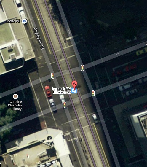
Hook turn from Elizabeth Street to Lonsdale Street east
People ask if trams are so great why were they removed from road systems throughout Australia, and burned in a bonfire of vanities in Sydney, in the 1950s? There is a short sharp answer to this: the hook turn.

Tram lines require vehicles to make right hand turns from the kerb side lane. The screen shot above shows vehicles making a hook right-hand turn in the Melbourne CBD. There are 25 intersections in the Melbourne CBD where hook turns are necessary - they are listed at this web site gps-data-team.info. The intersection of Elizabeth Street and Lonsdale Street had a hook turn in progress as the satellite was passing overhead so it will be used to demonstrate the principles of the turn. Traffic turning left or right share the kerbside lane. The main streets are so wide in the Melbourne CBD that up to three vehicles can wait to make a right turn without blocking traffic making a left turn in concert with the straight through traffic. The Road Rules of Australia require right turning traffic to wait for the cross street traffic lights to turn green before completing their turn - the cross-street traffic will wait for them to make their turn before setting off. If there are more than three vehicles wanting to turn right during a traffic light phase they must wait behind the pedestrian crossing until the next phase, blocking left and right turning vehicles alike.

 If straight-through traffic was also blocked this could lead to grid-lock. However there are further Road Rules to minimise the likelihood of this happening. Drivers are proscribed from driving past the back of a tram that is stopped at a tram stop, so passengers typically disembark and embark from trams onto the road tarmac, and vehicles can swerve onto the tracks so long as they do not queue in tram lanes at intersections.

The Australian Road Rules basically assume that there will be only two or three vehicle wanting to make a right-hand turn in each direction during each traffic-light phase. The Melbourne road system achieves this by directing most vehicular north-south traffic in the CBD into King Street which has no hook turns. Arterial roads such as St Kilda Road, which has tram lines along the centre, has a minimum of two lanes in each direction and has no hook turns. The Road Rules of Australia were not designed to cope with tram lines down the centre of a crucial arterial road.