Showing posts with label Kensington. Show all posts

Tuesday, 10 December 2013

The circus comes to Surry Hills


More TfNSW staff than locals
The TfNSW road show took over the first floor exhibition room at the Surry Hills Library for the last time before the deadline for submissions on the EIS. When I asked if I could take photos I was told that all the wall posters appeared on the web site. Only one of the display panels contained matter related to Surry Hills - the same panels had been used at every one of the "community" exhibitions.

I was eventually able to give my list of unanswered questions raise by the EIS to the "technical" guy at the presentation. I can report back on his responses.

He confirmed that LRVs would be travelling at the speed limit, 50 kph, when travelling through Surry Hills. Since the LRVs will have priority signaling at intersections, this is a voluntary constraint. He said that if Clover Moore lowered the speed limit in Surry Hills to 40 kph trams would travel at this speed. Why?

The response to questions on braking were "don't know". The engineer claimed that the trams could stop as quickly or more quickly as a rubber tyre vehicle but I disputed this - small steel wheels on steel rails have low friction. He said that the trams would have emergency brakes as well as regenerative braking but said it would be up to the PPP to decide the type of braking when ordering the carriages from overseas builders. He said the trams would run on batteries though the pedestrian areas. I pointed out that would limit the use of regenerative braking in emergencies as batteries can not be charged fast enough. He said that the trams would put up their electrical contacts at stops and recharge for the next leg. This means they will not be using regenerative breaking in ordinary operations, which may look pretty but sea levels rise. All this will remain unknown and will be decided by the PPP.

He conceded that a planting buffer would not ensure that pedestrians would use only traffic light controlled crossings and that the displacement of the stop into Ward Park would make it difficult to see an approaching tram from the rear of a stopping tram. He confirmed that ordinary services, which will stop at every stop and open and close their doors regardless of whether any one is getting on or off, would operate in conjunction with coupled carriages which will not stop. He said that safety specifications would need to be developed subsequent to the EIS.

The indicative plan of the Surry Hills stop developed by Parsons Brinckerhoff does not appear to have much relationship with the actual plans. He was unable to explain the bus in Marlborough Street and said the stop was not regarded as an bus/tram interchange. He said the Crown Street bus services would continue as before and I commented that they would be stuffed by the right-hand turn into the ghetto.

He had not seen the map of proposed key south east bus network changes on page 130 of the technical paper 1 or the table on the following page. He said the EIS and plans for changes to bus routes were regarded as separate issues. I was incredulous, saying the trams obliterated most of the "real estate" (Chris Lock's term) for buses to physically turn around in the CBD - at Circular Quay and Randle Street - and the EIS must not be approved until these questions had been resolved.

He could not explain how bus services reported in the table on the following page as being "terminated" at the Kingsford interchange, the Randwick interchange and Todman Avenue would physically turn around. Again, this was regarded as a separate issue to the EIS.

He could not explain how traffic in Clisdell Street could be physically tuned around at the blockage. I showed him a photo on my iPhone of the single lane at the intersection of Butt Street with Elizabeth. He conceded that the balcony of the flats had been damaged by trucks.

We discussed the infamous artist's impression of the Shakespeare Hotel at Steel Street in the original brochure. He agreed that patrons would be crossing Devonshire Street to their homes in the other ghetto. He asked how would this be different from dealing with rubber tyred vehicles at present. I pointed out that traffic at night at present is few and far between, but Saturday night is a peak period for travel between the cinema and night club areas in George Street and Parramatta Road bus services and Central, and the trams must continue to Randwick or Kingsford to turn around. There would be a tram passing along Devonshire Street every one and a half minutes as tired an emotional revellers were heading home. I asked if it was planned to build rickety overpasses between the ghettos. He smiled indulgently.

He was called away before we could clear up the discrepancies between the Parsons Brinckerhoff volumes and the Technical Papers by Booz & Company.

He was intelligent and forthright and he listened to the arguments against the Project and the alternatives and encouraged me to advance the matters I had brought up in my letter to the Minister in April in my submission to the EIS.

I have been waking up at 3 or 4 AM since the release of the EIS and going over the matters in my mind and I have not been able to go back to sleep. This morning I slept in to a quarter to seven. I have more confidence that the EIS will be professionally assessed.

Thursday, 5 December 2013

Day is done

I presumed before the release of the EIS that there was too little wriggle room between the sheer glass facade of the foyer of the NIDA theatre and the University of NSW building to provide for a hook-turn lane into Day Street and maintain two lanes of traffic around the tram stop. It turned out I was right.
I did not believe that anyone in their right mind would eliminate the turn into Day Street from Anzac Parade. Day Street is the sine qua non route for the Kingsford bus services which go along Eastern Avenue, and are also the mainstay of the bus services along Crown Street and Campbell Street in Surry Hills. The main parking area of NIDA is also accessible from Day Street.

 I probably got that right too; but none the less TfNSW will be eliminating the right turn into Day Street. Booz & Company proclaim it bluntly in Technical paper 1 5.4.4. Functional changes:

  • The right turn from Anzac Parade into Day Avenue will be banned. This will require rerouting of bus services that currently make this manoeuvre. Pending further Council approval and investigation of impact to bike lanes this route will likely to be via Doncaster Avenue.
That is to say the buses will crisscross the rails northbound as well as southbound.
21 CSELR EIS Technical Paper 1 5.4.4.
There will be no right-hand turns allowed from Day Street into Anzac Parade so the parking area shown in the Figure left will be accessible only from rat-runs through Kensington and Kingsford. The Day Street intersection has been cropped in this Figure.

In fact Kingsford is to be ghettoized; with the only access from the north to the entire Kingsford grid north of Gardeners Road being a single hook turn lane at Barker Street. The main retail strip will not only lose all bus stops except for a stop so far north of Strachen Street it has been cropped from the data in the EIS, it will lose curbside parking and customers will need navsat to reach off-street parking areas.

The ghettoization is not as overwhelming as the ghettoization of Surry Hills as there are tortuous rat-runs through Kensington, but I would not like to be in the position of someone who has superannuation invested in their business in Kingsford.

Wednesday, 4 December 2013

Terminator 4


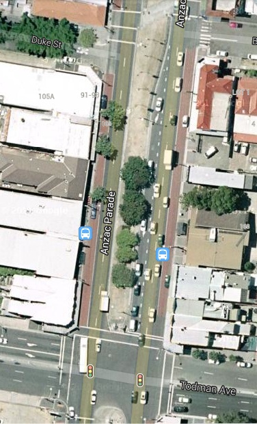
Anzac Parade north of Todman Avenue
There is no right-hand turn from Anzac Parade into Alison Road, understandably. To turn right drivers must think ahead or use navsat, and turn into Ascot Street then make the right turn from Doncaster Avenue. Ascot Street also gives access to the car park of Randwick Racecourse - to be obliterated. There is no right-hand turn from the northbound lanes of Anzac Parade into Todman Avenue so this traffic does not circle past the Kensington Primary School.

O'Farrell may be full of shit but he does not give a shit what happens to primary school students. He demonstrated this at Ward Park and Bourke Street Primary so at least he is consistent. The right-hand turn into Ascot Street is to be obliterated and a (presumably) hook turn introduced at Todman Avenue.
21 CSELR ESI Technical Paper 1 p 164
This information is provided in the Technical Paper 1 written by consultants Booz & Company. The text announces bluntly:
Right turn movements that provide access to Doncaster Avenue will be consolidated into a single right turn at Todman Avenue, as illustrated in Figure 5-13.

This was the first that residents of Kensington got to know of this. The EIS legislation requires that an EIS be exhibited for a minimum of 30 days and up to 90 days. The Minister is exhibiting this 3,000 word plus EIS for 32 days.

The wicked witch of the north has sprung another of her nasty surprises. This time it is the residents of Kensington that are her victims.

It gets worse, much worse. One has to deal with the usual deliberate deception that is systemic with this EIS.

The earlier diagrams of the Project from the 13 December 2012 brochure onwards showed the dot representing the "Todman Avenue stop" well to the south of Todman Avenue, which was consistent with the infantile modelling that required the dots to be roughly evenly spaced.

Now the other consultants, Parsons Brickerhoff, have produced the Figure 5.38 showing the stop to be to the north of Todman Avenue. There was of course no consultation with the local community or businesses about the move.

The "indicative plan" of the stop shows a bus icon (the light blue rectangle) on the westbound carriage-way of Todman Avenue. It could only have got there from Doncaster Avenue and it could not have reached here because the only right-hand turn is at Todman Avenue. This is deliberate deception designed to conceal the intentions of TfNSW.

The lanes at the intersection just reflect the existing situation and there are no arrows on the lanes. TfNSW is intent on concealing the intention to introduce hook turn lanes as they have at every intersection in the system. The usual method to do this is by cropping but this is not possible here so we have plan B - remove all lane markings.
21 CSELR Technical Paper 1 p 131
Getting back to TfNSW's Boozy consultants. The Table 4-1 details the fate of bus services when commuters are forced from the public bus services onto the privately operated cattle cars.

The La Perouse and Little Bay services operating along Bunnerong Road and Anzac Parade alike share the same fate:
"Operates existing route to Todman Avenue, Kensington and terminates". The consultants have copied the same words into five of the table entries - ain't word processors great?

You have probably spotted the obvious flaw in this scenario: It is physically impossible for buses to terminate at Todman Avenue. The only right-hand turn is into Todman Avenue and buses cannot do a U-turn in Todman Avenue. The Liberal Party curse has struck again - they can not comprehend that buses need space to turn around.

It should be noted that this table appears in the same volume of the Technical Papers as the disclosure of the right turns that will be permitted from Anzac Parade. This is not a case of different consultants coming up with contradictory plans.

So what are the residents and businesses of Kensington to make of all this? There is utterly no disclosure of what is meant by "terminate".

It probably means dump all passengers and proceed via the Eastern Distributor to Circular Quay, the only place where the buses can physically turn around. This was the qualified planning released before the exhibition of the EIS, reproduced (left) again from a previous post.

But it could mean dump passengers in the middle of nowhere south of Todman Avenue and turn left into Todman Avenue. There used to be tram sheds at the north west end of Todman Avenue but this is now a Supa Centa.

The citizens of Kensington had 32 days to find out.

Thursday, 1 August 2013

Nine Ways to kill a tramway.

Nine Ways roundabout Kingsford
The tram rails continue along Anzac Parade until they pass through the Nine Ways round-about and reach the broad centre islands between the carriageways of Anzac Parade east of Nineways where they inexplicably terminate at the dot named Kingsford. Trams could continue along the centre of Anzac Parade with minimal interference to traffic flows or bus services all the way to La Perouse. And this would be the explanation. Once the tram rails have reached the broad centre island they have achieved their purpose:

  • This is not a competently designed tram system. 
  • This is an irrational, idealogical attack on the Public Bus Services.

The business model for setting up a private company to build and operate the tramway requires the rival public bus services to be crippled, and for public bus services to be forcibly terminated at the two possible/future bus/tram interchanges.

There was a bus stopped at the bus stop leading into the inbound bus lane along Anzac Parade when the satellite was taking its snapshot. It is at the top of the screen grab but you can follow the arguments with Google Maps. The bus could have come from Anzac Parade like the other bus in the snapshot waiting to enter Nineways, but is more likely to have come from Bunnerong Road, which passes through more populated areas and carries many more buses. These buses have an exclusive route to the tidal bus lane along Anzac Parade, shown by the blue line. This route passes nowhere near the Kingsford tram terminal, so these services will compete with the trams. They are given short shrift by Transport for NSW.

Every vehicle travelling along Anzac Parade, west of Nineways, is forced into the one the only bus lane. It is not just the bus services along Bunnerong Road that will be crippled. there are bus services taking students and staff at the University of NSW to a various destinations, bus services through Kensington along Todman Avenue and Lenthal Street and bus services through Kingsford.

Wednesday, 31 July 2013

The impossible bus/tram interchanges.

Indicative only map from June 21st Significant Infrastructure Application
I am not aware of any road in Melbourne that carries both trams and buses, but then the Melbourne transport system was not designed by a self-proclaimed genius. The map above is from the Significant Infrastructure Application supporting document, released on June 21st, three weeks after the anonymous Department contributors leaked the names of the dots in the Wikipedia. This document is a legal requirement for an EIS and is available on the Transport for NSW website. The grab above is full size so the lack of discernible detail is quite deliberate.

We cannot say anything about the Carlton Street dot except the this is one of the crunch points that force all vehicles into the bus lane. We can note that the Todman Avenue dot is a long way south of its namesake, the horizontal white line, and the UNSW dot is midway between Day Avenue and High Street. This is inevitable. The one the only bus-and-every-other-vehicle lane must swerve around tram stops and hook-turn lanes, bus stops, loading bays, local short-term parking bays, set down bays for students driven to Uni, taxi ranks and service vehicle bays, ducking and weaving more often than an eco-nazi on the Randwick City Council. The kerbside lane beside the tram stop becomes the hook-turn lane and if this is not long enough to cope with the worst-case scenario then through traffic is blocked. Unfortunately the tram stops will be set in concrete and unable to cope with changed circumstances.

Bus stops are traditionally placed adjacent to cross roads, for obvious reasons: passengers who do not live or work directly on the route can use the footpaths of the cross road to reach the stop, rather than clambering over fences and rooves. If placed before the intersection, buses can be allowed to jump the queue of vehicles waiting to pass through the intersection, as at Taylor Square:
Queue jumping bus lane

Hook turns put an end to all this. Bus stops must be placed after the intersection. Even if bus passengers became frustrated with interminable congestion in the bus lane and left the bus en masse, and trekked back over the pedestrian crossing, over the length of the hook lane and over the extra pedestrian crossing, and transferred to a tram, the bus would have to carry on empty to the terminus because hook turn lanes prevent buses turning around.

The anonymous Transport for NSW authors of the Wikipedia article referred to the Kingsford and Randwick dots, the two termini, as possible bus interchanges which distinguishes them from all the other dots, which are impossible bus interchanges. They have now changed this description to future bus interchanges. That is future as in after the Environmental Impact Statement.

Sunday, 28 July 2013

The Kensington Wedgie

Kensington is defined by two of Sydney's most important arterial roads, South Dowling Street on the western boundary and Anzac Parade that passes thought the eastern side. The internal grid roads once connected to South Dowling Street but now terminate in a single lane feeder road, Samuel Terry Ave., running down from Todman Avenue. If you miss the left turn into Todman Avenue you are at the Domestic Airport before you can turn around. I am pretty sure this predates the Eastern Distributor. I caught a taxi to the Australian Golf Course in the 1980s and the driver could not find the entrance. He drove to Mascot and back and would have repeated the manoeuvre if I had not yelled at him to turn into O'Dea Avenue.

To reach destinations in Kensington from Eastern Australia from Kirribilli to Cape York you have a binary choice: you can turn left into Todman Avenue from South Dowling Street or right from Anzac Parade. I don't have off-street parking and there is a steep gradient so the bike is easy to knock over, so I arranged to leave it at a carport at a unit in Lenthal Street while I was in Broome. I missed the right-hand turn from Anzac Parade to Todman Avenue so I got to find out how far one has to go to turn around in Anzac Parade. I was able to make a right-hand turn into Day Street at an intersection without traffic lights just south of NIDA.

Day Street is the boundary between Kensington and Kingsford and is the only street distributing traffic to the whole of the Kingsford grid so this is an important right-hand turn. Without this turn all traffic to Kingsford from the north would have to turn into Todman Avenue and pass through Kensington. And the turn into Todman Avenue has enough to deal with. Satellites pass overhead at all different times so Google Earth choses times around noon, when there are less shadows, for their snapshots. The screen-shot above was not in the morning or afternoon peaks, but the right-turn lane, which stretches an entire block, was full of vehicles during the traffic-light phase in operation at the time of the snapshot.

In roads without tram lines right-hand turns take place simultaneously during the same phase or take place with only one direction blocked. However, hook turns where more than two or three vehicles typically turn right during a traffic-light phase, require separate right-turn phases for each direction, when nothing else moves.

So we can deduce that the right-hand turn at Day Street will be retained. Unfortunately hook turns at intersections without traffic lights are really scary. The driver must wait for a simultaneous gap in three lanes of traffic and two tram lines carrying, we are told, trams in each direction every two or three minutes. So the intersection will need traffic lights, and the hook turn will block both directions of traffic.

We can also deduce that the dot called University of NSW, NIDA will indeed be south of Day Street wedged between the buildings on each side of Anzac Parade. It will be a fair distance south to allow a left-hand turn lane into Day Street and will need its own pedestrian crossings.

We are in a position to assess the damage O'Farrell is inflicting on the public bus services along Anzac Parade:

  • Two lanes of vehicular traffic forced into the one and only bus lane.
  • At least one extra traffic lights controlled intersection.
  • Traffic flow impeded by hook turn phases throughout the length of Anzac Parade.
  • Extra pedestrian crossings at each tram stop.